All Activity
- Past hour
-
Par for the course around here lol
-
Wow didn’t know it was that long of a stretch.
-
 Did the same here at WXW1. Grueling stuff but it feels good when it's done. This GFS run also tries to bring tropical out of the Gulf at the same time Not sure how good a pattern that is for snow up at WXW2, but I feel pretty confident that we'll be getting below zero quite a bit if that Canada cold press comes through. Last December the village got below zero four times. KSLK got there six times.
 -

November 2025 general discussions and probable topic derailings ...
ORH_wxman replied to Typhoon Tip's topic in New England
Yeah def -PNA early on. There are some similarities to ‘07. Not exact match. -

November 2025 general discussions and probable topic derailings ...
H2Otown_WX replied to Typhoon Tip's topic in New England
An '07 redux? Are you thinking a -PNA for the first half of the month? -
.23 up here, anyone who better the over is cashing in, thought most of it was going to be to my south but what do those models know anyway?
-
This will be the 5th consecutive below normal precip Autumn, and the 10th out of 12. You have to go back to the 1950s/60s and 1910s/20s to find similar stretches. Rolling it forward, both of those periods were relatively snowy, but the current one is, um, not.
-
 70 is very possible
-
You better hope Anthony doesn’t read that, facts as there are.
-
This is all very helpful. We're closing in a couple days and we've been wondering whether we should get gutters or not. I don't want to spend thousands on something that's going to get ripped down in two years. Sounds like more insulation may be the better investment for now at least.
-
nice break in the clouds over MoCo, full sun here in Gaithersburg (near Laytonsville)!

-
0.26" north Smithtown
-
November 2025 general discussions and probable topic derailings ...
ORH_wxman replied to Typhoon Tip's topic in New England
Yeah the euro was trying to get us too on that 12/3-4 system. We’ll see. Volatile solutions in this setup so I’d expect a lot of swings in guidance. We’re still in clown range anyway but these are the types of patterns you can oscillate between 60F cutters and cold SWFEs until you get inside 6 or 7 days. (In the old days it might do that until 4-5 days out) -
Hanging outdoor lights in light rain drops and frozen fingers
-

November 2025 general discussions and probable topic derailings ...
kdxken replied to Typhoon Tip's topic in New England
-
0.26” for Syosset & 0.23” for Muttontown.
-

Central PA Fall Discussions and Obs
canderson replied to ChescoWx's topic in Upstate New York/Pennsylvania
I just bought a snowblower, so it won’t ever snow again. -
Records; Highs: EWR: 72 (1931) NYC: 72 (1931) LGA: 69 (1940) JFK: 67 (1983) Lows: EWR: 17 (2018) NYC: 13 (1880) LGA: 19 (2018) JFK: 18 (2018) Historical: 1641 - An observer at Boston, MA, recorded a great tempest of wind and rain from the southeast all night, as fierce as a hurricane, and thereupon followed the highest tide which we have seen since our arrival here . (David Ludlum) 1720: New York City had an early severe cold snap. Doctor Colden wrote "my ink freezes as I write". (Ref. Wilson Wx. History) 1957 - Extremely destructive Santa Ana winds blew from Oxnard to San Diego and inland parts of southern California. The high winds produced a 28,000 acre brush fire on a 40-mile front west of Crystal Lake. People were ordered off streets in some areas due to flying debris. (21st-22nd) (The Weather Channel) 1961: Hailstones 4 inches in diameter severely damaged all roofs of the region located about 25 miles southwest of Bradley Texas. Most of the area was ranch land so damage to property was small. However, a lot of dead deer were found in open areas literally beaten to death by the hail. (Weather Guide Calendar with Phenomenal Weather Events 2007 Accord Publishing, USA) 1979: One last record from the 1979 winter storm: Cheyenne, WY’s deepest snow cover on record was recorded on this day with a snow depth of 26 inches. (Ref. Wilson Wx. History) 1983: A snowstorm dumped 2 to 6 inches of snow over a large part of northwest, southwest and central Iowa. In addition, freezing rain accompanied the snow in some locations. The result was extremely hazardous roads and highways, with a glaze of ice underneath the snow. Power lines were downed by the ice, and many rural communities lost power for hours. Portland, OR received their 25th straight day of rain. (Ref. Wilson Wx. History) 1984: A strong low pressure system developed east of Florida, and coupled with a high pressure to the northwest created a strong pressure gradient that led to gale force winds along the east coast. As the low moved slowly north heavy rains of up to 7 inches fell over south Florida. Palm Beach, FL received 4 inches of rain in 4 hours. There was extensive coastal flooding and beach erosion with many structures damaged or destroyed. Fishing piers and seawalls were damaged or destroyed. Damage ran into the millions and was confined to the shore except where heavy rain in the south caused local flooding. A man was killed when he stepped on a downed power line. (Ref. Wilson Wx. History) 1987 - Eight cities in the eastern U.S. reported record low temperatures for the date. Elkins, WV, reported a low of 5 degrees above zero. Gale force winds continued along the Northern Atlantic Coast. (The National Weather Summary) 1988 - Wet and windy weather prevailed across the western U.S., with heavy snow in some of the higher elevations. Winds gusted to 62 mph at Vedauwoo WY, and reached 75 mph at Tillamook OR. Shelter Cove CA was drenched with 4.37 inches of rain in 24 hours. (The National Weather Summary) (Storm Data) 1989 - Strong northerly winds produced squalls along the shore of Lake Michigan, with heavy snow in extreme southeastern Wisconsin. Milwaukee WI received nine inches of snow, and in Racine County there were more than one hundred automobile accidents. (The National Weather Summary) (Storm Data) 1992: 45 tornadoes touched down in the Tennessee and Ohio Valleys. Georgia was hard hit with two F4, one F3 and three F2 tornadoes that killed 6 people and injured 144. Indiana had a total of 15 tornadoes on this day to set a record for an outbreak in November and for the month of November. One, an F4 multiple-vortex type, cut a 22-mile path through extreme southeastern Indiana and northern Kentucky. This tornado debunked the myth that twisters don't cross rivers, as this devastating tornado crossed the Ohio River twice. Indiana had a total of 15 tornadoes on this day to set two state records, the largest November tornado outbreak and the most tornadoes in November. This tornado outbreak made a significant contribution to what was to become the biggest November ever for the U.S. in terms of number of tornadoes. (Ref. AccWeather Weather History) 1993: A major, slow-moving snowstorm affected much of South Dakota from this date through the 27th producing prolific amounts of snow. The heaviest snow amounts in the 2 to 3 foot range occurred in northeast South Dakota and in the northern Black Hills. Storm total snowfall amounts included: 37.7 inches at Lead, 31.8 inches at Westport, 28 inches at Britton, and 25.3 inches at Aberdeen. The 25.3 inches at Aberdeen was a single storm snowfall record and it made this November the snowiest November on record in Aberdeen. Much of the eastern third of South Dakota was brought to a standstill on the 24th bringing an early start to the Thanksgiving Holiday. The weight of the snow collapsed numerous structures in northeast South Dakota. Strong northwest winds and cold temperatures followed the storm plunging wind chill values to -50°. Snowfall across northwest Iowa and southwest Minnesota for the storm was generally 5 to 9 inches. (Ref. Wilson Wx. History) 1999: The first significant snowstorm of the year pounded Colorado with up to 20 inches of snow at Fairplay southwest of Denver and 9 inches in Denver. The snowstorm reduced visibilities, causing a massive 83 car pileup on I-70 west of Denver. Two people were killed and 30 were injured in the giant accident. The first blast of wintry weather followed unusually warm weather that had Denver averaging 12 degrees above normal for the first 3 weeks of the month. (Ref. AccWeather Weather History) 2003: Record snow falls across the southern Yukon as a Pacific storm system moved inland. The weather station on the Klondike Highway recorded 8.7 inches of snow. Mayo Airport measured 8.3 inches, the greatest daily November snowfall since records began in 1926 and the fourth snowiest day ever. A few locations out west reported record low temperatures for the date including: Spokane, WA: -5°, Madera, CA: 27°, Merced, CA: 28°, Hanford, CA: 29° and Redding, CA: 29°-Tied. St. Paul, AK tied their record high with 43°. (Ref. Wilson Wx. History)
-
November 2025 general discussions and probable topic derailings ...
kdxken replied to Typhoon Tip's topic in New England
See this is why we need the mad face emoji. -

November 2025 general discussions and probable topic derailings ...
Lava Rock replied to Typhoon Tip's topic in New England
Did the final lawn cut and got rid of the leaves Sent from my SM-S921U using Tapatalk -
Aldie said it well…people are dumb
-
Thanksgiving and Black Friday continue to look cold after the front pushes through. We’re hosting about 15 family members at Deep Creek so looking forward to a cold holiday…hopefully some lake effect/upslope snow for the kids (and more importantly, me ).
-
November 2025 general discussions and probable topic derailings ...
ORH_wxman replied to Typhoon Tip's topic in New England
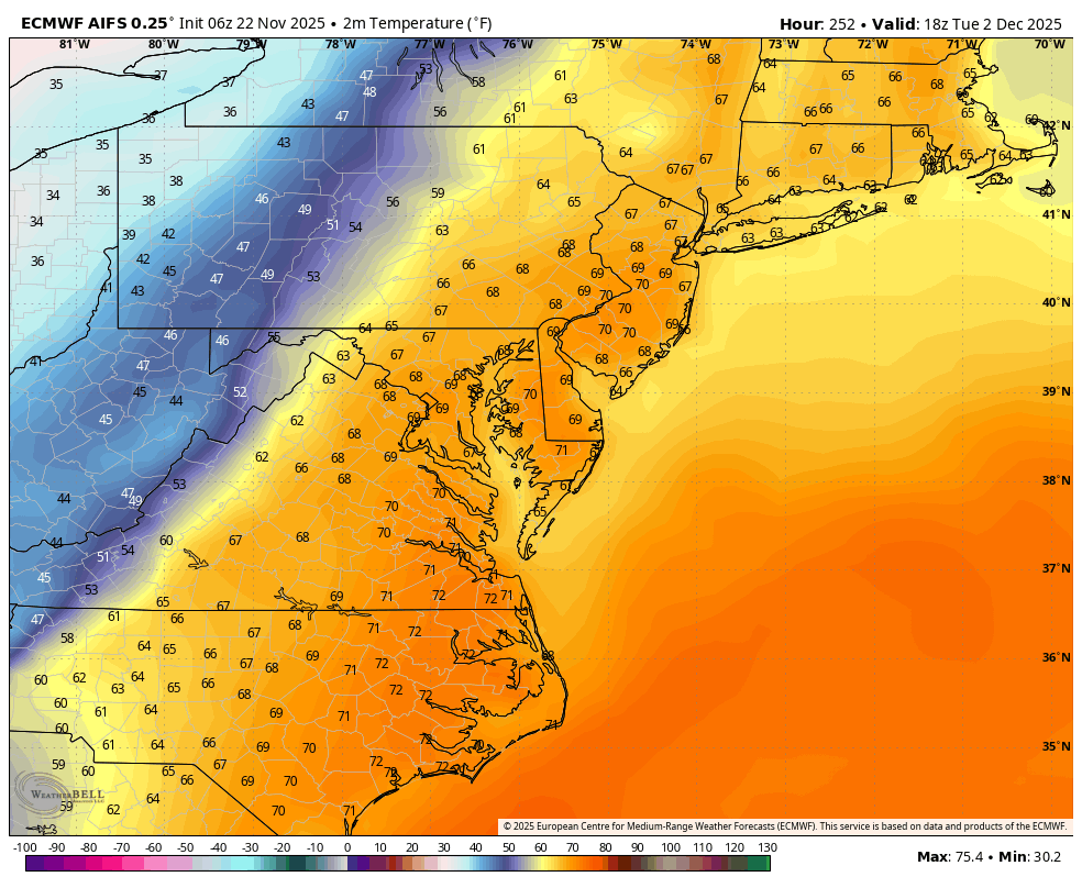
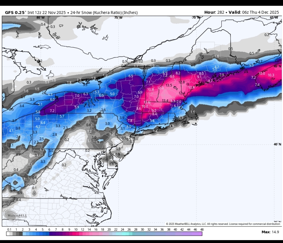
We’ll have a torch spike on the cutter the first few days of December (whenever that thing actually cuts…still wiggle room on guidance)….but we may drop the hammer after that. Canada is frigid and we start getting that cold -WPO cross-polar press. It’s hard to stay warm with that look. I’d be surprised if we didn’t have multiple SWFE threats between 12/5-12/15. Might even be able to sneak something a touch sooner. Esp NNE. -

2025-2026 ENSO
donsutherland1 replied to 40/70 Benchmark's topic in Weather Forecasting and Discussion
Yes. I used a full progression through Phase 2 for fuller insight. I plan to take a closer look at the MJO cases. -
50 / 48 drying out a bit and slowly clearing later. Warmer 11/22 - 11/26 then below 11/27 - 11/30 before moderating warmer to open next month. Appears a back and forth between the cold and warmth and in between at times.