All Activity
- Past hour
-
Euro AI like Tuesday for big warmth and that’s about it.
-
Got down to 29 here
-
lawn is waking up and going green. will be raking out the beds and towing the lawn sweeper around this weekend. Tractor oil change/maintenance done. ready to rock and roll!
-
how much did you wind up with ? I bet with high sun shining on snow, the dry wet-bulb actually ends up being a sublimation hisser. It'll be evaporating like dry-ice man. The sun doesn't just 100% bounce off the snow... it will warm the molecules in air-contact interface, to above the DP temp and that's evaporating quickly. Like an "acid layer" eating into it. It's less like melting pack and more like going directly to gas at an accelerated rate that way. But obviously.. one wouldn't notice this if you have a ton to start
-
Yeah, we are right on the cusp of leaf out. Once that happens evapotranspiration increases dews and lowers higher end temp potential. We can even rapidly warm up right to the coast pre leaf out before the sea breeze kicks in. .
-
Not sure that’ll happen up here with snow cover and low wetbulbs. Too much albedo today combined with evap/subliminal cooling.
-

Central PA Spring 2026 Discussion/Obs Thread
Summit Snow replied to Voyager's topic in Upstate New York/Pennsylvania
Down to 16 this morning. -
The 4/23 ONI fcasts: BoM much too warm and Euro/CFS/UK somewhat too warm. Actual JAS +1.37 1. BoM: +2.17 for JAS or 0.80 too warm 2. Euro: +1.57 for JAS or 0.20 too warm 3. CFSv2: +1.56 for JAS or 0.19 too warm 4. UKMET: +1.58 for JAS or 0.21 too warm OTOH, the avg of all 17 dynamicals was +1.33, which was almost perfect. ONI history: https://www.cpc.ncep.noaa.gov/data/indices/oni.ascii.txt 4/23 ONI forecasts: https://iri.columbia.edu/our-expertise/climate/forecasts/enso/2023-April-quick-look/?enso_tab=enso-sst_table
-
What a beautiful blue sky today. Have seen several high planes/jet contrails traversing the skies today.
-
Oddly, I like that feature. When I first saw it, wasn't a fan.
-
-
-2 at Saranac Lake. Pretty legit cold for April.
-
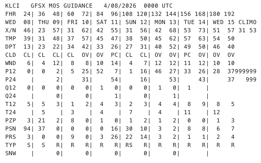
As an aside, today and tomorrow both should bust MOS like 1-3 F I think. It's not a huge or even noticeable thing. Not 'busts' per se. Just that we are Sep 3 sun equiv, with just about as unadulterated solar as is physically doable on this planet, with the possible exception of say 1,000 miles out amidst the Sahara ... I doubt these machine numbers have the lowest 500 feet of explosive super adiabats locked down. It's a fetish of mine to test MOS in April and May
-
38.9 this morning felt especially chilly after the hot weather stretch we’ve been in
-
Always take the over on our warmups and take it even higher with dry ground and no foliage on trees
-
Just get through tomorrow morning and the last vestiges of winter will be behind us.
-
I think I could still be on the warm side of things…especially Tuesday. Wed is more fragile. But if it ends up 68° with sun here while it’s 83° at BDL I’ll have no complaints.
-
We're definitely seeing 90+ next week. We already saw mid 80s in March
- 234 replies
-
- 2
-

-

-
- april showers bring may..
- rain
- (and 2 more)
-
I suppose if you have 6 days to know it's coming by the time it does, meh. When it comes to na na na-na scaling ( haha ), in order of irate the least is that one. 3 is knowing for days your fucked. Oh k... gradual acceptance. 2 is surprisingly BD's ... you'd think they'd be #1 but no... Usually you have some inkling that a BD is possible. Also, knowing it's BD time of year ... 1 is when it is warm for days in the charts. Plans are made. Then, the models pull the rug at that sweet 36 hours ahead deliberate look. This rendition is the most annoying. To help qualify this .. imagine a historic blizzard, not like that isolated SE Mass job last Feb... I mean interior VA to Maine, in 2-3 feet of snow, with a stall off Montauk Point across 2 cycles of Lunar tides, for 5 days of guidance. Nat Guard is on call... APs are preemptively canceling flights. General states panic as ems light up FEMA web-site graphic. General state of dopa O.D. awe --> 36 hours out that first model run with nothing. umm
-
24 for a low
-
KFIT GFSX MOS GUIDANCE 4/08/2026 0000 UTC WED 08| THU 09| FRI 10| SAT 11| SUN 12| MON 13| TUE 14| CLIMO 33 55 X/N 48| 24 59| 35 66| 44 60| 32 60| 44 70| 55 75| Heh, nothing like being 20 points above climo at both ends of the diurnal range, at 6 days lead time in a MOS product that is pretty heavily weighted toward climatology at that range ... I do think next week is kind of 'first test' for this summer - personally - because I feel this year's season has a shot at some historic heat. The reason primarily being the pan-dimensional dry antecedent continent, with lower persisting soil moisture anomalies, right as we are about to jump into the highest sun angles of the year. Keep in mind, we are less than 1 month from solar max entry... on or about May 6. We just need to shed the 90/60 polar vortex and things can turn around and catch civility off-guard. We still live in a CC-enraged synergistic heat event planetary system and that's not going away... This seems to be a good candidate year to test if we send the mercury into over-achieving warm results, both relative to pattern... but relative to "when it gets hot". Again, we need to get the patterns ...so we'll see. In the meantime, this next Tues/Wed, if that boundary does hull up NW and leaves our region soaked in WSW flow of dry kinetically charged air mass, that's an opportunity to over perform. Being 20 over climo weighting at D6 isn't trivial
-

Central PA Spring 2026 Discussion/Obs Thread
canderson replied to Voyager's topic in Upstate New York/Pennsylvania
26 at home too. The tulips looked sad this morning. -
WU has me at 86 next Tuesday.
-
IAD barely touched 32, and not till *after* sunrise.


