All Activity
- Past hour
-

Mountain West Discussion
mayjawintastawm replied to mayjawintastawm's topic in Central/Western States
Today could finally be better... or not... wow this monsoon thing and the AM stratus/PM nothingburger pattern is so weird. Let's see if we can double our monthly rainfall- would not be hard. -
Its going to be a bake, But its one with Lobsters............
-
At first glance, this reads like a thinly veiled reference about how stoned you are going to get.
-
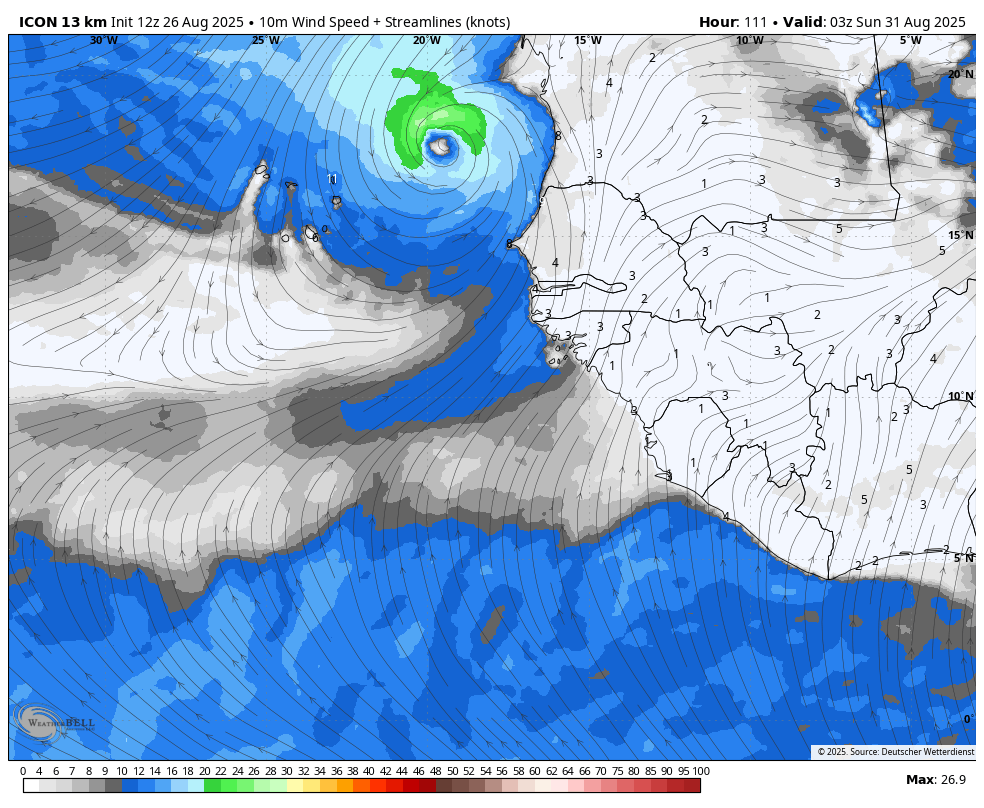
Sorry, I have no idea. The 12Z Icon is another run with it. It comes off Africa Fri night and is already a TD on Sat/Sat night:

-
I mean, can’t really complain about 72/52 and blue skies.
-
Going to Cabbage Island Friday on the Bennie Alice out of Boothbay Harbor, The showers can stay away for that.
-
Is that not exactly you're doing by using just the years within the 1991-2020 average and nothing else? You're dropping 100 of the 136 years of records because they make this year's averages seem warmer by comparison. Would you look back on June 2025's +1.3 as a "cooler" month just because the 2001-2030 averages might place it as a -0.2, even if it ranks 20th warmest of 136 years?
-
It doesn't look like a total wash out. Some towns may end up slipping through gaps in a couple line of showers/thunder, while other's get a couple doses. But not like raining all the time. I guess play it by ear
-

2025 Atlantic Hurricane Season
BarryStantonGBP replied to BarryStantonGBP's topic in Tropical Headquarters
people are debating whether Gabby is a CV storm or a frontal EC storm if she is the CV storm how strong do you think she could get? -
Different locations over a 138 year period is far from a fair comparison. It was literally a different old around Harrisburg 20 years+ ago, let alone 138 years. This reminds me of an old friend of mine. When we were in college and I used to go out "carousing" looking for women, he would always remind me that "if a girl doesn't meet your standards, lower them." That’s what you're doing by changing the standards by which to determinetemp anomalies. Why don't we go back further then and use ice core samples? We look pretty cool to me based on times further back. But you'll have your reasons I'm sure. I've made my point, so anything further is unnecessary.
-
Same around here, between that and the 60s, fall is really hitting nice
-
Definitely a cool start to the day. Check out the difference between the Baltimore City and Towson sites.
-
how rainy is Friday looking in SNH? ton of yard work to do
-
What's the deal with the Atlantic SSTs over the past week? They fallen off a cliff. Looks like it may be from Erin, pretty amazing to see how much of an impact a tropical system has on that.
-
My current HI is 107 and it's not even 11am. 92/77 here in Key West. Here until Friday, back home Sunday. Saw the cold front made it all the way down to southern Georgia. Impressive for August.
- Today
-
Dont shoot me for saying it, but it was chilly. and I put a vest on to go to work. Just gawjous weather we are having...like pinch me and tell me its not August weather. Couple that with another dud for hurricane activity (so far- although it may get interesting next month), and I'm happy as hell.
-
I’m up in the mrv and it’s about as dry as I’ve ever seen it. Lake Champlain lowest in 75 years. Perfect biking weather so no complaints.
-
Yeah, I dunno. Personally? I wasn’t attempting to qualify it one way or other - the advent of it is sort of a symbolic rite of passage. Perhaps even right on schedule. Some suggestion in the deep range that it will at least turn warmer again .. how much so unknown
-
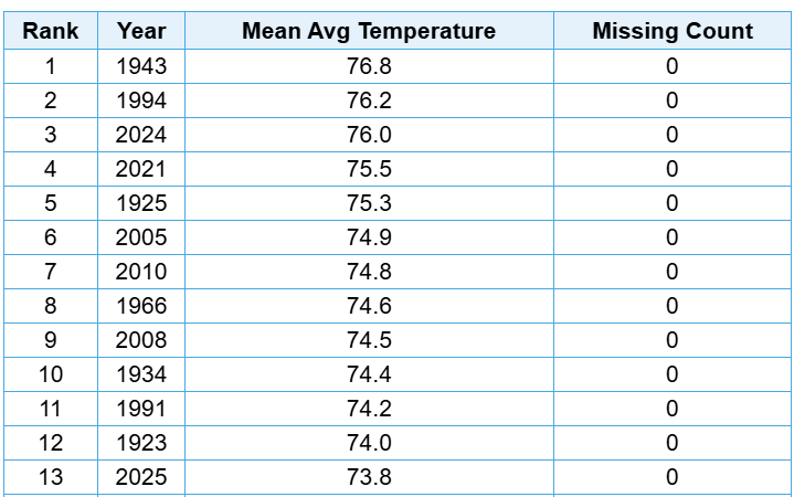
I was using the extended climate record for your area which started back in 1888. Past Climatological Periods At Middletown-Harrisburg Area in Middletown-Harrisburg, PA (MDTthr) Period of record: 1888-07-01 to 2025-08-25 (current) - 138 Year(s) Time Series Summary for Middletown-Harrisburg Area, PA (ThreadEx) 20 warmest summers dense rank sorting by temperature Click column heading to sort ascending, click again to sort descending. 1 2020 77.9 0 2 1966 77.6 0 3 2016 77.3 0 4 2021 77.1 0 5 2024 76.9 0 6 2010 76.8 0 7 2022 76.7 0 - 1999 76.7 0 8 2019 76.5 0 - 2005 76.5 0 9 1991 76.4 0 10 1900 76.2 0 11 1943 76.1 0 12 2002 76.0 0 13 2025 75.9 6 14 2011 75.6 0 - 1995 75.6 0 15 1994 75.5 0 16 2018 75.4 0 - 1955 75.4 0 - 1949 75.4 0 17 1993 75.3 0 18 2012 75.2 0 - 2006 75.2 0 - 1988 75.2 0 19 1974 75.0 0 - 1973 75.0 0 - 1939 75.0 0 20 2015 74.9 0 - 1952 74.9 0
-
The models have had a hard on for pinching off a mid level low over Brian for some reason … heh. … whatever he did to incur this wrath aside it appears to be legit. It’s only 4 days away so -
-
What's to hate about that
-
Are you telling me that this wording Wasn't meant to push any sort of agenda that this Summer was not as warm as others claim? bluewave brought up that you're comparing against the warmest 30 year average, which is a completely valid criticism. From what I can tell June's "only +1.3" is 13th warmest out of 136 years. Words like "only" or "barely AN" are only applicable if we isolate the current 30 year average as the baseline for absolute warmth or cold. That is way more narrow of a scope than what bluewave did, comparing to the entire range of years. Comparing against 136 years is a way better benchmark than just 30.
-
Just like yesterday’s 12Z and today’s 0Z, the 6Z Euro has the low come off Africa Fri evening (not that far out…that’s why I think it’s worth posts). It becomes a TD Saturday night near the CVs, moves slightly S of due W from there, and ends up near 16N, 30W at 144 still as a TD. If this keeps up a few more runs, it would call for a lemon, especially with the CVs potentially impacted within only 5 days. Edit: Actually, with rather strong support by the Euro and Icon, some support by the CMC and JMA, and on/off support by the UKMET, I feel that if the Euro/Icon were to hold onto this at 12Z and if the UKMET were to get it back, it would then already be lemon-worthy even if the GFS still doesn’t have it.
-
 this is what it takes for average temps in the mid latitudes ,
 -
Saturday looks like an early autumn vibe in the air... kind of like the shot before the shot across the bow air mass. 69 to 71 highs? Not these faux suggestions merely because we're sensing the daylight slipping and it happens to not be as hot … when it's still climate okay and sun strength to actually be hot ... lol. But don't tell that to the ACATT crew, huh. Anyway, it looks like hydrostats slip beneath 560 for the first time in months. That's an important metric/distinction for me. Also, with cool pool mid level wobbling over CNE, we're probably going to pancake and shade the sun. So less shoulder offset.

.thumb.png.4150b06c63a21f61052e47a612bf1818.png)


.thumb.jpg.ad3a2e31d30aff035044689b311a0540.jpg)


