All Activity
- Past hour
-

First Winter Storm to kickoff 2025-26 Winter season
powderfreak replied to Baroclinic Zone's topic in New England
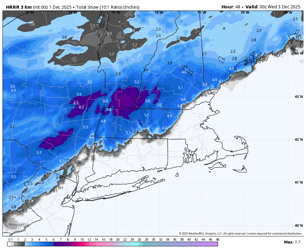
Your area is probably the most interesting of anyone on the forum. That southern Middlesex County zone has been consistently modeled as the battle ground on all guidance. Like could certainly be 8-12" of paste, or like 3-4" of 4:1 slop. -
High not running off coast as fast
-
This is a better setup IF the EPS is right. Just a tad too far north and east
-
This thread should actually be extended to December 2nd (Tuesday) since it would last through at least that said morning. Not much on the 12z Euro: A bit juicy on the 00z NAM: So-so on the 18z GFS:
-
Thursday night looks very cold. Teens for many.
-

First Winter Storm to kickoff 2025-26 Winter season
Ginx snewx replied to Baroclinic Zone's topic in New England
True -

First Winter Storm to kickoff 2025-26 Winter season
CoastalWx replied to Baroclinic Zone's topic in New England
Can we get a Euro track with Nam dynamics? lol. -
Adding to the list!! Thanks Mappy
-

First Winter Storm to kickoff 2025-26 Winter season
Snowcrazed71 replied to Baroclinic Zone's topic in New England
I will gladly take 2-4 here. For those who said they would rather have nothing than 1-3/2-4... They might as well get off this thread and wait for the "BIG" one. -
First Winter Storm to kickoff 2025-26 Winter season
Ginx snewx replied to Baroclinic Zone's topic in New England
Until the Euro moves more, it literally has had the same general look for days, color me skeptical as every trend for the major models has been south. -

First Winter Storm to kickoff 2025-26 Winter season
WxWatcher007 replied to Baroclinic Zone's topic in New England
He’s had a rough week lol -

First Winter Storm to kickoff 2025-26 Winter season
AstronomyEnjoyer replied to Baroclinic Zone's topic in New England
Latest (21z) NWS Blend..thumb.png.1816635a41b5f2d8e13869e059b233a5.png)
-

First Winter Storm to kickoff 2025-26 Winter season
ORH_wxman replied to Baroclinic Zone's topic in New England
Yeah we were tossing those NAM solutions with lots of confidence at 72-84 hours. It was well beyond what even the most amped globals had. I think the most surprising aspect is how little the euro has moved. If anything it moved south until finally ticking back north a little at 18z. I kind of expect a pretty even compromise between it and GFS now which will end up as the common 70/30 from a couple days ago. -
First Winter Storm to kickoff 2025-26 Winter season
Ginx snewx replied to Baroclinic Zone's topic in New England
Hmm not what was said by some yahoo rains to Maines -
First Winter Storm to kickoff 2025-26 Winter season
powderfreak replied to Baroclinic Zone's topic in New England
HRRR extended has trended that way too like the NAM.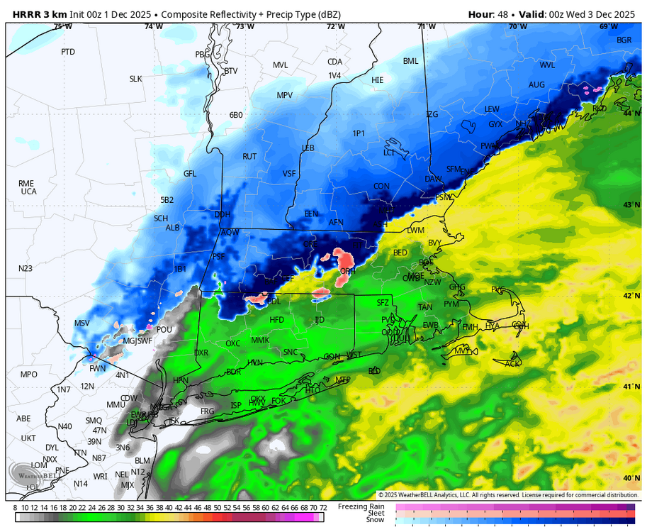

-
Man, if only we had some blocking in place for the 6-10th timeframe… .
-
First Winter Storm to kickoff 2025-26 Winter season
WxWatcher007 replied to Baroclinic Zone's topic in New England
Yeah that was never going to happen -
Thursday, December 4, 2025 3:58PM EST Extreme Cold, High Wind and Blizzard warnings are in place across the region in anticipation of the historic storm about to commence over the region. This storm will have many similarities to the Great Appalachians Storm of late November 1950 except the whole setup will be shifted east by a few hundred miles. … Nestor will continue to be absorbed into the large surface low deepening off the Carolinas over the next 12 hours or so as a result of the deep and record cold trough and embedded shortwave approaching the coast. Temps have already fallen into the teens northwest of I-95 and will fall through the night into the low to mid-single digits areawide on strong NNW winds gusting to around 40 to 50 mph. This will bring windchills down into the -20 to -30F range in the greater DC metro area, hence the Extreme Cold Warning in place. As the night wears on the large upper-level trough will start to cutoff as the shortwave rounding the base of said trough takes on a strongly negative tilt. This will result in the surface low deepening explosively as it begins to track to the northwest back towards the Mid-Atlantic coastline. This will throw snow back into our region from east to west through the predawn hours reaching the Blue Ridge by sunrise. Friday, December 5th and Saturday, December 6th will be two days that are remembered for the long time in these parts. As the surface low continues to deepen bands of very heavy snow will be thrown west across the region as NNW winds gust over 60 mph areawide with some gusts pushing 75 mph in the mountains and near the coast of the Chesapeake Bay and the Potomac River. Temperatures will remain in the 0 to 5F range throughout the day as well, meaning windchills will be as low as -25 to -30F. Snowfall rates of 3 to 4 inches per hour will be common leading to whiteout conditions. The snow, cold and wind combo will make even being outside very dangerous if not adequately bundled up for the elements. The heaviest snow and highest winds will last through the late evening and into the early overnight hours. But the storm will be long from done. The surface low will stall and spin over or just off of the Delmarva allowing blizzard conditions with heavy snow and strong winds to continue throughout the day on Saturday. Temps on Saturday may actually warm into the double-digits… generally 10-15F raising windchills into the -5 to -15F range. It won’t be until late Saturday night into Sunday morning when the surface low rotates to the east and out to sea allowing the snow to taper off from west to east throughout the night. Snowfall totals: Snowfall totals will be truly historic and life-altering with 45-65” being commonplace across the Greater Metro area. However, owing to the high winds and the low water content of the snow, snow drifts may be as high as 35 feet burying homes and businesses underneath the snow. Winds: Winds gusts will peak in the 60 to 70 mph range (locally 75 mph) from Friday afternoon through about midnight (12am) Saturday but will continue gusting over 50 mph through Saturday evening. Temperatures: Temperatures will fall into the lower single digits late tonight and hold steady within a few degrees of this through predawn Saturday before rising into the lower teens by Saturday afternoon.
-
.thumb.jpg.ad3a2e31d30aff035044689b311a0540.jpg)
Winter 2025-26 Medium/Long Range Discussion
nvck replied to michsnowfreak's topic in Lakes/Ohio Valley
should be a nice early-season event for parts of IN and OH that missed out on the past weekend's big one.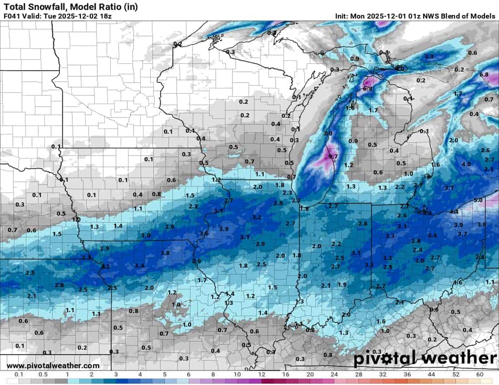
-
39/37 A whopping .01" for the day. Perfect day to watch football
-
First Winter Storm to kickoff 2025-26 Winter season
CoastalWx replied to Baroclinic Zone's topic in New England
Nam was jacking NNe. I mean it had to come south. -
Honestly, I’d be content with 2” of snow up this way at this rate. Trends aren’t encouraging
-

First Winter Storm to kickoff 2025-26 Winter season
78Blizzard replied to Baroclinic Zone's topic in New England
Looks to me like the cave is coming from other than the Euro. -
Kind of makes sense given the high is sliding east off the coast — a SE flow - on December 2nd
-

December 2025 regional war/obs/disco thread
Torch Tiger replied to Torch Tiger's topic in New England
it's more reasonable looking , though probably a bit too amped


.png.dd254ad54a96ad52190873990a23eebf.png)