All Activity
- Past hour
-
Def smoky here . Hazy look
-
6z GFS was close with.a cane
-
Can we tariff Canadian wildfire smoke?
-
It’s coming for all.
-
 Expanded data back to 2010 - looks like Mon, Tue then 8/10 and beyond could add to those - no strong heat (95+) but do see plenty of 88 - 91 days through the 13/14th before perhaps more sustained warmth / heat towards the middle , second half of august. EWR can get there with a N/NNE/E with right amount of sun.
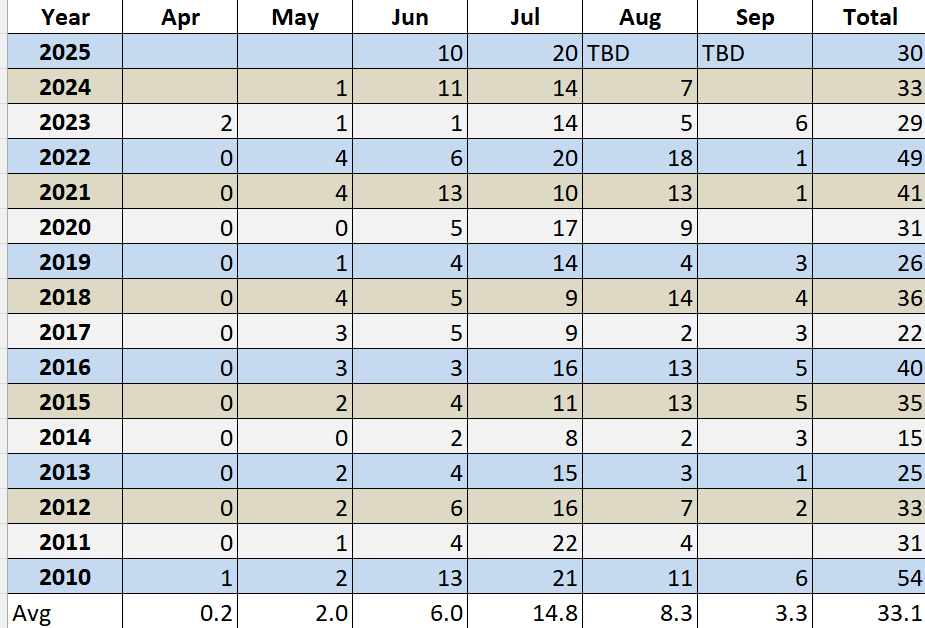
-
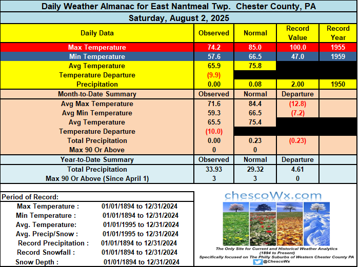
This morning’s low of 55.7 was the chilliest morning here in East Nantmeal since the 55.1 reading back on June 4th. The lowest temperature around the county this morning was the 52.3 at the Warwick Township station. The first 2 days of August have averaged around 10 degrees below normal temperatures. Today will continue the below normal start to the month, but we have a quick 2 day warm up on Monday and Tuesday with temperatures not too far from average in the mid 80’s. Starting Wednesday we chill down a bit again with temperatures finishing out the work week a few degrees below normal. There is no rain at all in the forecast for this week.

-
80s is perfect not a hint of smoke. We Arctic blue

-

E PA/NJ/DE Summer 2025 Obs/Discussion
ChescoWx replied to Hurricane Agnes's topic in Philadelphia Region
This morning’s low of 55.7 was the chilliest morning here in East Nantmeal since the 55.1 reading back on June 4th. The lowest temperature around the county this morning was the 52.3 at the Warwick Township station. The first 2 days of August have averaged around 10 degrees below normal temperatures. Today will continue the below normal start to the month, but we have a quick 2 day warm up on Monday and Tuesday with temperatures not too far from average in the mid 80’s. Starting Wednesday we chill down a bit again with temperatures finishing out the work week a few degrees below normal. There is no rain at all in the forecast for this week.
-
Was interesting watching this thing spin up right in front of me down in Carteret county. Had squalls from all directions. Picked up 2.12” of rain but only had a high gust of 35mph just off the water. High sustained was about 20mph.
-
Got down to 53 in Marysville this morning.
-
[mention=564]Bluewave[/mention] Was your MJO fall indicator for winter September or October? So far, since spring the MJO waves have been very heavily favoring phases 5-6-7, but with nowhere near the record strength/amplitude we saw last year
-
Records: Highs: EWR: 101 (2006) NYC: 97 (2005) LGA: 100 (2006) JFK: 99 (2006) Lows: EWR: 57 (1953) NYC: 55 (1927) LGA: 59 (1953) JFK: 56 (1964) Historical: 1864: A waterspout over Albemarle Sound, NC passed perilously close to the Union Fleet at anchor. The crews of the ships watched "in awe" as the whirlwind dissipated as it moved onshore. (Ref. Wilson Wx. History) 1885 - A tornado hit Philadelphia and Camden along its eight mile path. (David Ludlum) 1885: A tornado causing estimated F3 damage hit Philadelphia and Camden along its eight-mile path. Six people were killed and damage totaled $500,000 dollars. Other tornadoes causing estimated F2 damage touched down in Cecil County, Maryland, New Castle County, Delaware and Bucks & Chester Counties in Pennsylvania. (David Ludlum) 1894: After two record heat waves in July, record cool weather arrives. Lansing, MI fell to 32° for a rare summer freezing temperature. (Ref. Wilson Wx. History) 1898: Philadelphia, PA had one of their worst thunderstorms ever when 5.84 inches fell in just 2 hours. The hydraulic pressure in the city sewers caused by the force of the accumulated runoff created overflows via toilets, basins, and sinks to rise to second floor levels in some cases. (Ref. AccWeather Weather History) 1899: A tropical depression was born in the tropical Atlantic. Before it finally dissipated a record 33 days later, it became known as the San Ciriaco Hurricane after a Puerto Rican village the storm devastated. Its life as a hurricane was 27.75 days, a record for the Atlantic Basin beating Hurricane Ginger of 1971 by three-quarters of a day. (Ref. Wilson Wx. History) 1960: A home in Wauponsee Township, IL was struck by two tornadoes within 4 hours. The first one struck around 7 PM and the second around 11 PM. The house sustained significant damage to the roof, wiring and appliances. (Ref. AccWeather Weather History) 1964: Muskegon, MI set an August record and tied their all-time record high temperature at 99°. The temperature hit 100° at Grand Rapids, MI a record for the date. Owen, WI set their all-time record high with 101°. (Ref. AccWeather Weather History) 1970 - Hurricane Celia struck the coast of Texas producing wind gusts to 161 mph at Corpus Christi, and estimated wind gusts of 180 mph at Arkansas Pass. The hurricane was the most destructive of record along the Texas coast causing 454 million dollars damage, and also claimed eleven lives. (David Ludlum) (The Weather Channel) 1974: Brooklyn, CT -- Lightning struck and killed a youth when he was running from a tent toward home at 2:40 a.m. (Ref. Lightning-The Underrated Killer.pdf) 1975: Boston, Massachusetts had a 83 °F temperature the warmest minimum temperature. (Highest minimum on Boston's records) (Ref. NOAA Boston Weather Events) 1981: Severe thunderstorms tore across portions of central and eastern South Dakota. Near Hoven, a steel bin building was lifted off the ground by a small tornado and carried about 30 feet before it wrapped around a tree. In Faulkton, winds gusted to 97 mph at the Faulkton airport. The extremely high winds destroyed an airport hanger and damaged a grain elevator. At Redfield, 70 mph winds leveled an outdoor movie screen and flipped a plane. (Ref. Wilson Wx. History) 1986: The minimum temperature of 69° is first below 70 °F recorded in the past 28 days at DCA. (Ref. Washington Weather Records - KDCA) 1987 - A severe thunderstorm moved across Cheyenne, WY, during the mid afternoon. The thunderstorm produced hailstones up to two inches in diameter causing more than 37 million dollars damage. The eastern U.S. sweltered in the heat. A dozen cities reported record high temperatures for the date, including Paducah KY with a reading of 102 degrees. Beckley WV established an all- time record with an afternoon high of 93 degrees. (Storm Data) (The National Weather Summary) 1988 - Thunderstorms developing ahead of a slow moving cold front produced severe weather from the Central High Plains to the Upper Great Lakes Region. Thunderstorms around Fort Collins, CO, produced wind gusts to 74 mph along with marble size hail. Sixteen persons were injured in the storm, most of whom were accidently locked out of their office building, having evacuated it when the fire alarm went off, apparently triggered by lightning. (Storm Data) (The National Weather Summary) 1989 - Thunderstorms representing what remained of Hurricane Chantal drenched Wichita, KS, with 2.20 inches of rain in four hours during the early morning. Thunderstorms developing in Minnesota produced wind gusts to 85 mph at Baudette during the afternoon, and softball size hail at Lake Kabetogama, during the evening. Jamestown, ND, reported a record hot afternoon high of 103 degrees. (Storm Data) (The National Weather Summary) 1993: Chesterfield County, VA lightning struck and killed a 30-year-old man as he mowed his lawn. (Ref. Lightning - Virginia Weather History) Workers desperate to save the historic town of Prarier du Rocher, IL during the Mississippi River Flood deliberately broke a 1,000 foot hole in a levee near the town to divert water headed toward the town from a levee break upstream. The quick action worked, saving the town. (Ref. Wilson Wx. History) 1994: Fairbanks, AK recorded their hottest August temperature ever with 93°. (Ref. AccWeather Weather History) 1995: Hurricane Erin was nearing the coast of the Florida Panhandle. The hurricane had emerged into the Gulf Mexico the previous day after crossing the Florida Peninsula. By early morning, Erin's sustained winds reached 100 mph in a small area near its center. A 98-mph wind gust was observed at Mary Esther Field and Fort Walton Beach, FL. The storm came ashore near Pensacola, FL later that morning causing six fatalities and an estimated $700 million damage. The barrier island stretching from Pensacola Beach to Navarre Beach absorbed the brunt of the storm as it came ashore near Pensacola. Sustained winds of 94 mph and gusts up to 103 mph were measured at Pensacola during the height of the storm. Seven people were reported missing at sea. 2002: Two campers at Natural Chimneys Regional Park in Augusta County, VA were struck and injured by lightning. (Ref. Lightning - Virginia Weather History) 2003: Severe thunderstorms moved over parts of the Chicago Metro area during the early afternoon. The storms produced golf ball size hail along with heavy rain and flooding. 4.14 inches was reported in just 90 minutes six miles east of O’Hare Airport. Four to six feet of water covered the closed Kennedy Expressway. Several tents were blown down at an outdoor festival in Roselle. These storms continued into the evening producing more large hail. The National Weather Service at Romeoville reported nickel size hail for five minutes and 1.60 inches of rain in just 30 minutes. (Ref. Wilson Wx. History)
-
52F for the low. Last night was spectacular. Very rare to be able to light the firepit in August.
-
Yea winds here in the Outebanks are sustained from the NE 20-30 with gusts to 40 mph. Water is closed to swimmers double red flags as the ocean is running 5-8 feet.
-
 All Newark needs to have another year with 40 days reaching 90° is to approach the 2010-2024 average of 11 days after July 31st. Time Series Summary for NEWARK LIBERTY INTL AP, NJ - Jan through Dec Most 90° Days Click column heading to sort ascending, click again to sort descending. 1 2010 54 0 2 2022 49 0 - 1993 49 0 3 1988 43 0 4 2021 41 0 - 2002 41 0 - 1991 41 0 5 2016 40 0 - 1983 40 0 - 1959 40 0 6 1994 39 0 - 1944 39 0 7 2005 37 0 - 1987 37 0 8 2018 36 0 - 1949 36 0 9 2015 35 0 10 1961 34 0 11 2024 33 0 - 2012 33 0 - 1999 33 0 - 1995 33 0 - 1966 33 0 12 1955 32 0 - 1953 32 0 - 1943 32 0 13 2020 31 0 - 2011 31 0 - 1973 31 0 - 1952 31 0 14 2025 30 151 Monthly Number of Days Max Temperature >= 90 for NEWARK LIBERTY INTL AP, NJ AVG 90° days Aug to Oct Since 2010 Click column heading to sort ascending, click again to sort descending. Mean 8 3 0 11 2024 7 0 0 7 2023 5 6 0 11 2022 18 1 0 19 2021 13 1 0 14 2020 9 0 0 9 2019 4 3 1 8 2018 14 4 0 18 2017 2 3 0 5 2016 13 5 0 18 2015 13 5 0 18 2014 2 3 0 5 2013 3 1 0 4 2012 7 2 0 9 2011 4 0 0 4 2010 11 6 0 17
 -

2025 Spring/Summer Mountain Thread
Buckethead replied to Maggie Valley Steve's topic in Southeastern States
Sitting at 52° with fog and drizzle in Wolf. Sent from my SM-S908U using Tapatalk -
Beautiful morning. 47.1 under clear skies. What a day.
-

2025 Spring/Summer Mountain Thread
Maggie Valley Steve replied to Maggie Valley Steve's topic in Southeastern States
I had a low of 60 this morning. I saw Mt Mitchell had a low of 48 shortly after 7 AM! 51 days until Fall. -
Record Number of Extreme 10”+ Rainfall Months Since 2003
bluewave replied to bluewave's topic in New York City Metro
Updating for July 2025 with several spots in NJ approaching and exceeding 10 inches of rain for the month. Monthly Data for July 2025 for New Jersey Click column heading to sort ascending, click again to sort descending. AEROFLEX-ANDOVER AIRPORT WBAN 16.54 HOWELL TWP 3.7 SSW CoCoRaHS 12.87 JACKSON TWP 4.9 ENE CoCoRaHS 12.22 MANASQUAN 1 NW COOP 9.75 WALL TWP 2.5 ENE CoCoRaHS 9.58 NORTH BRUNSWICK TWP 1.5 W CoCoRaHS 9.28 STAFFORD TWP 2.8 NNW CoCoRaHS 9.26 MANASQUAN 1.0 WNW CoCoRaHS 8.96 WOODBRIDGE TWP 3.0 NNW CoCoRaHS 8.76 GREEN BROOK TWP 0.9 S CoCoRaHS 8.60 CLARK TWP 0.7 SSW CoCoRaHS 8.58 HAMILTON TWP 4.5 NW CoCoRaHS 8.53 LONG HILL TWP 1.8 WSW CoCoRaHS 8.52 CLARK TWP 1.3 ENE CoCoRaHS 8.44 NEW PROVIDENCE 0.8 ESE CoCoRaHS 8.41 EDISON TWP 1.9 N CoCoRaHS 8.33 NEPTUNE CITY 0.1 E CoCoRaHS 8.22 Atlantic City Area ThreadEx 8.08 ATLANTIC CITY INTL AP WBAN 8.08 WESTFIELD 0.8 WSW CoCoRaHS 8.06 SOUTH BRUNSWICK TWP 3.1 NW CoCoRaHS 7.77 NEW BRUNSWICK 3 SE COOP 7.69 New Brunswick Area ThreadEx 7.69 -
Low of 53
-
58 imby, Tipton airport hit 55.
-
71 / 59 and another beaut of a day on tap. Warmer than yesterday by a few mid 80s. Monday warmer still with some inland areas to 90. With a similar Tue. Likely see clouds push back in on Wed from the south and clear out Thu, with the brunt of the rain down into MD and points outh. Overall near normal week - dry and lots of sunshine. Flow remains manly onshore the next 5 days with flow coming around more southerly with a warmer / hotter and wet overall next week. 8/3 - 8/8 : Near normal / below - dry overall - Wed/Thu clouds - rain looks to stay southwest 8/8 - beyond : Warm- Hot / Humid - wet overall - Tropics - heat for the area targeting the 9-12 period.
-

2025 Atlantic Hurricane Season
BarryStantonGBP replied to BarryStantonGBP's topic in Tropical Headquarters
-
2. Central Tropical Atlantic: A tropical wave is forecast to move off the west coast of Africa in the next day or two. Thereafter, some gradual development of the wave is possible during the middle to latter part of next week while it moves generally west-northwestward across the central tropical Atlantic. * Formation chance through 48 hours...low...near 0 percent. * Formation chance through 7 days...low...30 percent.


.thumb.JPG.418e8a9a2902ae687ec35ff4bc0e038e.JPG)


