All Activity
- Past hour
-

Hurricane Erin: 105 MPH - 958 mb - NNW @ 10
NJwx85 replied to BarryStantonGBP's topic in Tropical Headquarters
The system is still really far South and there’s plenty of OHC to be had. If the shear relaxes enough there could be another period of steady intensification tonight. The fact that the core was destroyed might actually be better off because it was never the same after the first EWRC and was headed towards that hollowed out tire mess. -
if that asshole has any proxy in the matter, no will survive the cold and flu season anyway
-
We just had the yard sprayed yesterday for ticks and skeeters. (Sorry Dendrite). I'd like to be disease free.
-

Hurricane Erin: 105 MPH - 958 mb - NNW @ 10
olafminesaw replied to BarryStantonGBP's topic in Tropical Headquarters
The core was essentially completely destroyed. Will be a little surprising to see it rebuild, but that convection is really impressive so we'll see.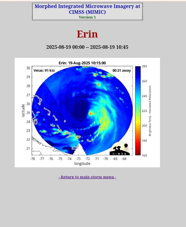
-

-

Mid to long range discussion- 2025
WinstonSalemArlington replied to wncsnow's topic in Southeastern States
Morning 50s next week -
Do we get some rain tonight? I have barely accumulated a quarter of an inch this month. Seeing a lot of early leaf drop and grass looks worse than even last year.
-

Hurricane Erin: 105 MPH - 958 mb - NNW @ 10
GaWx replied to BarryStantonGBP's topic in Tropical Headquarters
12Z Euro hour 24 isn’t nearly as strong as the 919 mb of the 6Z as this run gets it down “only” to 945 and is WNW of the 6Z. -
Throw in the exceptional amount of SAL for this time of year and it will be on the struggle bus for a spell.
-
I’m not sure but am thinking this 12Z UKMET might be for 99L: E of Bermuda moving NNE at the end: NEW TROPICAL CYCLONE FORECAST TO DEVELOP AFTER 114 HOURS FORECAST POSITION AT T+114 : 25.7N 64.2W LEAD CENTRAL MAXIMUM WIND VERIFYING TIME TIME POSITION PRESSURE (MB) SPEED (KNOTS) -------------- ---- -------- ------------- ------------- 1200UTC 24.08.2025 120 26.9N 63.9W 1012 34 0000UTC 25.08.2025 132 29.9N 63.3W 1012 30 1200UTC 25.08.2025 144 32.0N 62.6W 1012 28 0000UTC 26.08.2025 156 34.8N 61.8W 1013 28 1200UTC 26.08.2025 168 37.5N 60.9W 1013 29
-
-

NEW DISTURBANCE: Central Tropical Atlantic (10/60)
NorthHillsWx replied to BarryStantonGBP's topic in Tropical Headquarters
As others have said, I’m a little surprised that model support has waned on this system. It seemed to be in a moist pocket and shear seemed manageable. I do wonder if models are now catching onto the pronounced outflow from Erin as a source of shear that affects this system. It could be one that doesn’t get going until Erin moves away. Also, guidance has continued to trend more towards this system moving north through the same break Erin is traveling through. The chances of an east coast impact seem to be diminishing -

Hurricane Erin: 105 MPH - 958 mb - NNW @ 10
Seminole replied to BarryStantonGBP's topic in Tropical Headquarters
That is lot of SAL for this time of year. WOW! -
Hurricane Erin: 105 MPH - 958 mb - NNW @ 10
GaWx replied to BarryStantonGBP's topic in Tropical Headquarters
12Z UKMET: like the 0Z this run restrengthens Erin to a peak Thu evening off NC, but by not as much as it gets down to 947 vs 928 on the 0Z: HURRICANE ERIN ANALYSED POSITION : 25.3N 72.1W ATCF IDENTIFIER : AL052025 LEAD CENTRAL MAXIMUM WIND VERIFYING TIME TIME POSITION PRESSURE (MB) SPEED (KNOTS) -------------- ---- -------- ------------- ------------- 1200UTC 19.08.2025 0 25.3N 72.1W 961 79 0000UTC 20.08.2025 12 27.0N 73.1W 960 71 1200UTC 20.08.2025 24 29.0N 73.8W 954 83 0000UTC 21.08.2025 36 31.7N 74.0W 950 84 1200UTC 21.08.2025 48 34.1N 73.1W 949 81 0000UTC 22.08.2025 60 36.1N 70.7W 947 76 - Today
-
Yeah it’s not looking good. I have my peak season forecast due tomorrow and I’m still not sure which direction I’ll go in.
-
Hurricane Erin: 105 MPH - 958 mb - NNW @ 10
NorthHillsWx replied to BarryStantonGBP's topic in Tropical Headquarters
Definitely wrapping up shear. Winds have responded on the last leg of recon, more supportive of a borderline cat 2. -
For your granddaughter: ……. “comhghairdeas o’ chroi’” ….. as always …

-

NEW DISTURBANCE: Central Tropical Atlantic (10/60)
WxWatcher007 replied to BarryStantonGBP's topic in Tropical Headquarters
Posting for others to see. I know it’s there and that every system is different, but Erin was able to get past SAL and develop. Even this wave has convective activity. But the 12z GEFS signal declined near the Antilles too. Maybe it doesn’t develop, or maybe it’s a late developer. I lean toward the latter at this point, with the SW Atlantic being more favorable perhaps. -
RFK making sure they'll always be shitty now.
-
I also wonder if environment in the wake of Erin will be a bit too hostile for the follow up wave? Or at the very least wind shear may be unfavorable...GFS doesn't look great in this department.
-
Going to Breckenridge first week of Feb
-
Airing out a couple jackets today. Getting ready for the "freezing" blast of possible upper 40's next Monday night in August! Bring it! lol
-

NEW DISTURBANCE: Central Tropical Atlantic (10/60)
eyewall replied to BarryStantonGBP's topic in Tropical Headquarters
There is a big Saharan air layer out there -
Dry month here so far. 0.48" with not much on the table going forward. Glad July was very wet.
-
If your able, edit photos in Paint on your desktop. I change them to GIF, and, if need be, reduce their size. Helps a lot.