All Activity
- Past hour
-

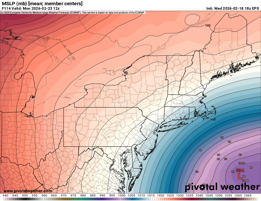
Feb 22nd/23rd "There's no way..." Storm Thread
ravensrule replied to Maestrobjwa's topic in Mid Atlantic
I let Mitch hit the softballs you lobbed up. -
-

-
Tick tick Courtesy of a meteorologist from another forum.
-

Feb 22nd/23rd "There's no way..." Storm Thread
mitchnick replied to Maestrobjwa's topic in Mid Atlantic
Are you just repeating what your wife's been telling you all these years? -

Feb 22nd/23rd "There's no way..." Storm Thread
WxUSAF replied to Maestrobjwa's topic in Mid Atlantic
Good happy hour. I’m not going to kick a 2-4” event out of bed if that’s what it ends up being. -

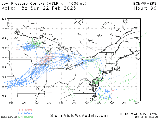
Late February/Early March 2026 Mid-Long Range
Scarlet Pimpernel replied to WxUSAF's topic in Mid Atlantic
I know there's a lot of focus obviously on this upcoming weekend, but did anyone else notice that guidance has been showing a decent window around the March 3-5 period now for a few days? We'll see if that's real, but I'm getting a bit intrigued now that something has been showing up around then. -
Yeah, euro had a much better evolution than it's been showing previously. Keep getting those little adjustments at 00z...
-

E PA/NJ/DE Winter 2025-26 Obs/Discussion
Newman replied to LVblizzard's topic in Philadelphia Region
I mean, even as is, much of SE PA gets a light 1-3" snow from the H5 pass on the Euro. I don't think there's a single model that is a complete whiff. -
Bad call. Major improvement vs. 12Z, both in surface low being over 100 miles NW and actually getting 1-3" along 95 and 3-4" towards the NJ coast, vs nada at 12Z. Looks similar to 6Z which people were gushing over.
-
Weathergeek - how do we feel about euro AI your favorite looking terrible still, while every other model improved? Wondering how you are handling this emotionally. .
-

Richmond Metro/Hampton Roads Area Discussion
ORFDawg2013 replied to RIC Airport's topic in Mid Atlantic
Sounds like the 18z Euro was an improvement, though baby steps, compared to 12z -

“Cory’s in NYC! Let’s HECS!” Feb. 22-24 Disco
ineedsnow replied to TheSnowman's topic in New England
better as in still a miss but closer -
Eps and euro op are quite similiar. Both made a big west shift.
-

“Cory’s in NYC! Let’s HECS!” Feb. 22-24 Disco
40/70 Benchmark replied to TheSnowman's topic in New England
Some of the earlier runs reminded me of Juno. -

E PA/NJ/DE Winter 2025-26 Obs/Discussion
Duca892 replied to LVblizzard's topic in Philadelphia Region
Still needs a lot it seems, but we still have about a 100hrs to go yet -

Feb 22nd/23rd "There's no way..." Storm Thread
winter_warlock replied to Maestrobjwa's topic in Mid Atlantic
Yes a definite improvement. I hope Tonights 00z runs continue the trends we've seen at 18z -
Or, better yet, do what the GFS does and turn that more meridional. In that position it would close it off just south of LI
-

“Cory’s in NYC! Let’s HECS!” Feb. 22-24 Disco
SouthCoastMA replied to TheSnowman's topic in New England
again, 12z was very bad. Better as in good? or better as in still a miss but closer? -
18z euro a huge positive step towards gfs/cmc. I just hope it’s not an off run hiccup. If we build off it at 00z we’re in the game.
-

Pittsburgh/Western PA WINTER ‘25/‘26
SteelCity87 replied to Burghblizz's topic in Upstate New York/Pennsylvania
With how rare those events are I'd never turn one away. -
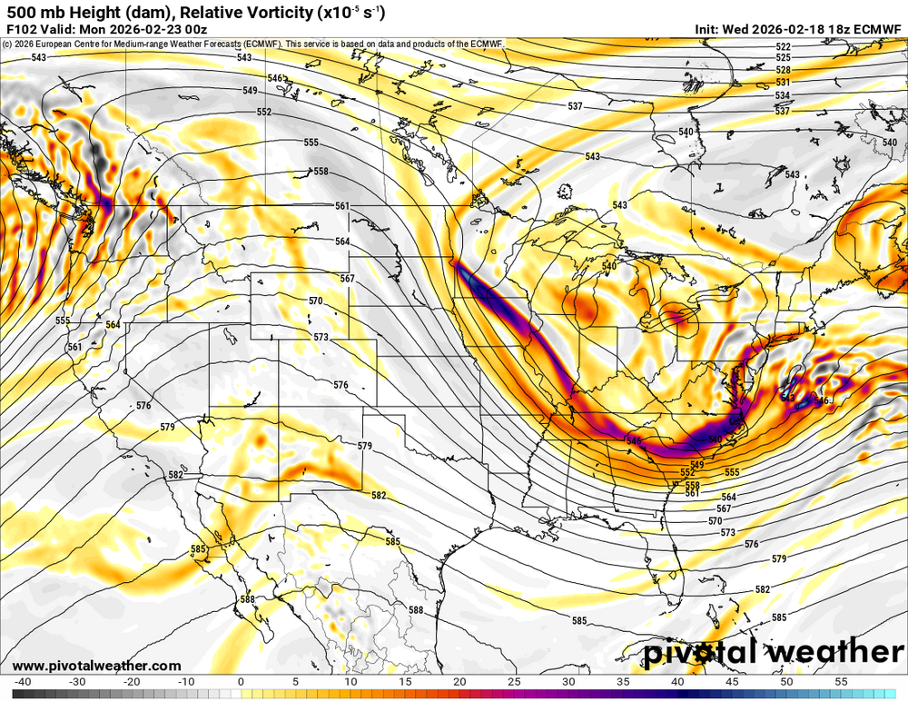
Again, we can work with that look at 500mb the big verbatim hits are fun and give that dopamine rush, but at this lead time all we need is for the pieces to be in play
-

“Cory’s in NYC! Let’s HECS!” Feb. 22-24 Disco
Ginx snewx replied to TheSnowman's topic in New England
Having flashbacks to Juno . Just kept coming NW starting day 5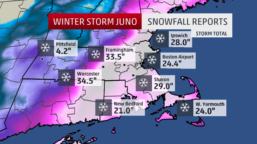
-
“Cory’s in NYC! Let’s HECS!” Feb. 22-24 Disco
ineedsnow replied to TheSnowman's topic in New England
EPS better! -

Central PA Winter 25/26 Discussion and Obs
mahantango#1 replied to MAG5035's topic in Upstate New York/Pennsylvania
From DT: THIS WEEK IN WX VIDEO TONIGHT LETS MONGER ABOUT SUNDAY MONDAY POSSIBLE EAST COAST WINTER STORM Just to give you all a clue…..Yesterday and again this morning and again this evening. NOAA/ NWS flew reconnaissance aircraft into the eastern Pacific to get a better sampling of the upper atmosphere and to make up for the loss of data from closure of several key weather stations in the upper planes in Midwest, which used to end up with the balloons to gather information about the atmosphere. The fact that the national weather service had to send out extra planes into the eastern, pacific to gather this data speaks to how badly the overall weather models have performed recently because of the lack of information from the weather stations that have been partially shut down in the upper Midwest. Guess what happened when they flew those planes and gather the extra data? They were a huge changes in what the models are showing is going to happen for Sunday Monday. Full details and discussion tonight on the weather video around 1030pm


