All Activity
- Past hour
-
https://x.com/AndyHazelton/status/1964683857149493603
-

September 2025 OBS-Discussion centered NYC subforum
doncat replied to wdrag's topic in New York City Metro
1.30" rain here since yesterday and 1.68" since Thursday.... a cool 65° currently. -

E PA/NJ/DE Autumn 2025 Obs/Discussion
Hurricane Agnes replied to PhiEaglesfan712's topic in Philadelphia Region
And it looks like the front has moved the band to coastal NJ and it's starting to clear here, with the sun trying to pop in and out. The rain gods gave me an extended, much needed soaking, with nothing over around 0.5"/hr. Ended up with 0.87" in the bucket for today, so along with the 0.01" just before midnight, I have a 2-day event total of 0.88". Currently 68 and clearing, with dp 63. -

September 2025 OBS-Discussion centered NYC subforum
anthonymm replied to wdrag's topic in New York City Metro
What model guidance is suggesting the ridge moves east? -

September 2025 OBS-Discussion centered NYC subforum
bluewave replied to wdrag's topic in New York City Metro
The source region to our west will really be warming up by next weekend. Remember the models missed the 90° heat yesterday from the 6-10 and 11-15 day forecasts. This is what I was discussing back in late August when no 90° days were showing up. So if we can get one of the big highs over Southeast Canada to drop down to the Carolinas, then the usual warm spots like Newark could make it to 40 days reaching 90° if the winds turn more SW. -

E PA/NJ/DE Autumn 2025 Obs/Discussion
Birds~69 replied to PhiEaglesfan712's topic in Philadelphia Region
I was going to guess 1 - 1.25" but it was probably more your amount... . -
E PA/NJ/DE Autumn 2025 Obs/Discussion
Birds~69 replied to PhiEaglesfan712's topic in Philadelphia Region
Besides some initial downpours yesterday afternoon it's been light to semi mod rain off and on. And no thunder boomers...C-. Sun is out... -

E PA/NJ/DE Autumn 2025 Obs/Discussion
MGorse replied to PhiEaglesfan712's topic in Philadelphia Region
0.82” total here. Currently 66F. -
September 2025 OBS-Discussion centered NYC subforum
anthonymm replied to wdrag's topic in New York City Metro
Seriously doubt. Next 10 days at least will be normal to below normal, and by the time late september/early october arrives, climo works against 90 really really hard. Mid to upper 80s not out of the question last week or so of September though. - Today
-

September 2025 OBS-Discussion centered NYC subforum
wdrag replied to wdrag's topic in New York City Metro
I see nothing that excites a thread from me for our NYC subforum for the next week or two, maybe longer? Glad I didnt thread yesterday. Some severe and iso flooding NJ (4+ in Monmouth County per CoCoRaHs). Overall, the global model guidance defied drier stats, beginning from late August and the wetter global guidance broadly verified, max qpf axis always to be adjusted. You'll see the Fri-Sun combo results tomorrow. I am observing a dead Hurricane Season so far, and note also that I thought this was a quiet summer for severe here in our NYC subforum. Have a day, Walt -
That’s insane.
-
The NPAC is kind of delicious.
-
2.27 so far
-

2025 Atlantic Hurricane Season
BarryStantonGBP replied to BarryStantonGBP's topic in Tropical Headquarters
-

E PA/NJ/DE Autumn 2025 Obs/Discussion
BBasile replied to PhiEaglesfan712's topic in Philadelphia Region
Looks like I'm gonna finish with 2.30". A couple inches over 24 hours... Perfect. 63.6F -
Just wait till winter when it's sleeting up here to your NW... it's raining from CON southward... and you and Dendrite are wedged in at 29F watching dual pol mix line washing out to the west/south and ripping 8-10" of silver dollars in a 6 hour thump.
-
.21" this event. .56" August and September
-
https://x.com/AndyHazelton/status/1964658176609116561
-
1.00" Sent from my SM-S921U using Tapatalk
-
If a seasonal forecast model gets any aspect of its winter forecast correct, then I will give it credit. The storm track aspect and well below normal snowfall forecast worked out. Even if the temperatures and 500mb pattern were significantly off. So the very fast Pacific flow and Southeast ridge found ways to emerge right during our biggest storm dates last winter. The last time we saw any seasonal forecast get most of its seasonal forecast correct may have been the JMA for the 13-14 winter issued during that October. As a general rule, computer modeling doesn’t have much skill beyond 1 to 2 weeks out. My guess is that they just run with a stock composite for whichever phase of ENSO we are in. So when we got a mismatch like my early outlook last October suggested, the stock La Niña composite didn’t work out. The record WPAC warm pool prevented the Euro colder pattern forecast for the 23-24 El Niño in much of the East from developing. Instead we got the record warmth. During the 22-23 La Niña the much stronger -PDO interaction with that pattern resulted in a much deeper Western trough than forecast. So we got the record warmth in the East that the model missed. 21-22 had the record December -PNA and warmth which the seasonal forecast couldn’t see. Plus the MJO 8 in January which couldn’t be seen beyond a few weeks out. The overall 3 month average for that winter wasn’t too far off. But of course the finer details were significantly different. 20-21 missed the +PNA December mismatch again from the October MJO signal that year. It was the first time I used it for a seasonal discussion that year back in the NYC Metro forum. The 19-20 colder Euro forecast was off that year since the El Niño couldn’t couple due to the record WPAC warm pool along with the fall IO forcing leading to the record SPV and strong +AO +NAO. The Euro 18-19 forecast was also off since its colder El Niño forecast couldn’t couple due to the record WPAC warm pool.
-
1.52 After some ridiculously dry months, some decent rains the last few weeks
-
Just about done other than some very light rain/drizzle. Would be nice to see a little sun this afternoon. 1.68" total. Only 2" for the month of August, so much needed.
-
Perfect weather for the first NFL Sunday of Met fall!
-

September 2025 OBS-Discussion centered NYC subforum
Brian5671 replied to wdrag's topic in New York City Metro
doesn't even show rain in the hourly obs today either-something is broken there -

September 2025 OBS-Discussion centered NYC subforum
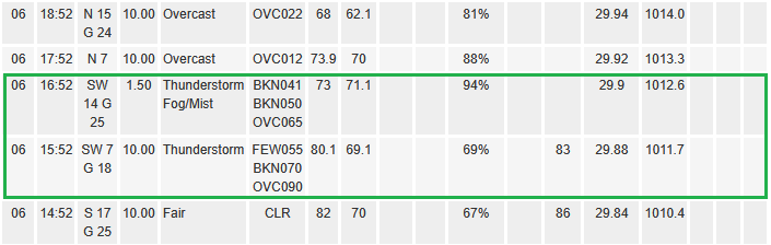
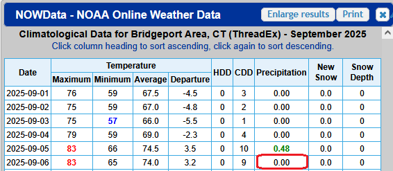
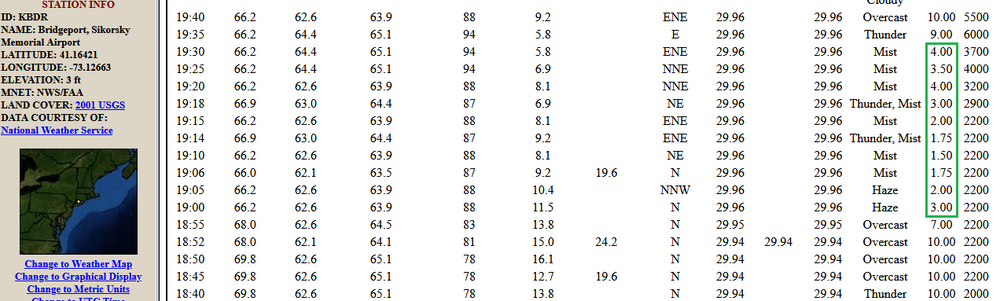
donsutherland1 replied to wdrag's topic in New York City Metro
For the second time in less than a month, Bridgeport is not reporting its precipitation. Yesterday's hourly data: The lowered visibilities are consistent with falling rain: Yesterday's NOWData: In sum,Bridgeport had measurable rainfall yesterday. That data was not recorded. So far, today's rainfall has also not been measured.