All Activity
- Past hour
-
MRX mentioning the potential for some high ratio snow next weekend and close to record breaking cold. By Friday, troughing to the northwest will deepen and become more broad with the Arctic high reaching 1045mb or greater as it progresses into the Great Plains. There will also be focus in the Gulf and Atlantic where a strong system is expected to develop and track up the coast through the weekend. Based on the latest data, this track continues to keep impacts well to our east. However, as the Arctic high expands into the area, moisture may be sufficient for light snow Friday into Saturday. QPF totals currently looks to be light, but the extent of cold air suggests snow ratios would be high. Regardless, the more significant impact will be another expansion of bitterly cold air, potentially worse than we are currently seeing. Ensemble data suggests 850mb temperatures to drop below -15 Celsius, possibly even near -20 Celsius. Values this low are nearing record values and certainly not seen with regularity. Highs on Saturday may struggle to get out of the teens for many with single digits for some a couple of nights. Saturday and Sunday will likely be below freezing area-wide, at a minimum. So any snow that does fall could be here for a few days.
-
 As an onlooker from outside the area perusing, I think I’m losing my mind reading your posts. Any storm that gives ORH and BOS 22”+ is going to be remembered by many.
 -
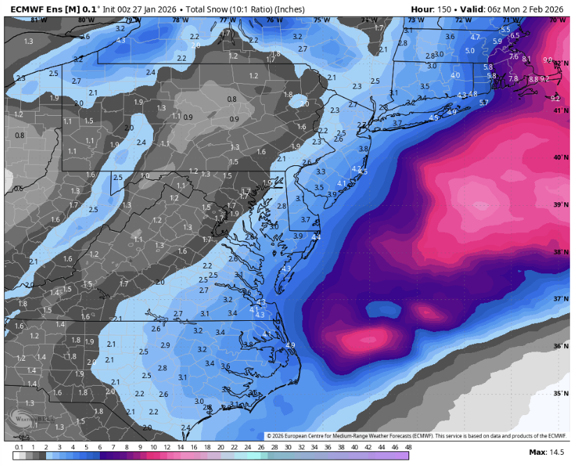
EPS mean still delivers a few inches snow - ratio's probably higher than 10:1 - liquid QPF Map - don't have access to snow map
-

Possible coastal storm centered on Feb 1 2026.
Torch Tiger replied to Typhoon Tip's topic in New England
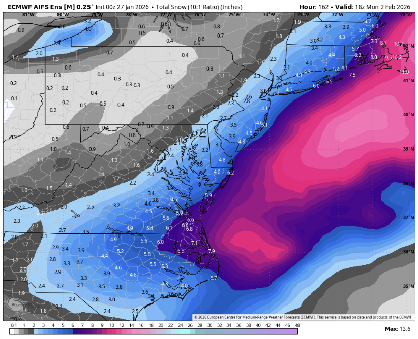
euro ai good for far eastern areas, heartbreaking elsewhere. - Today
-
16.9
-
2m temps means something but it is much more about what goes on upstairs. Need Bob Chill or one of the Mets to explain this better than I could, lol. It's something about the DGZ, Dendritic Growth Zone or something like that. Remember the last storm in Virginia? Ground temps in the low teens? Sleet falling in 13 degree temperatures and people saying this is so ridiculous? It was all about what was happening upstairs. I think it was because of a strong warm layer at about 700mb or something like that over top of the incredibly frigid airmass over the Mid Atlantic that caused the warm layer to dump rainfall that froze into sleet pellets because it was so damn COLD in the boundary layer. Or something like that. I really should leave this to degreed Mets or qualified hobbyists like Bob Chill or PSU or even SnowinOutThere. He needs a red tag stat. I sure don't. All I am, is an old man, all played out, can't even dig snow anymore, can hardly walk on ice down here in Texas without falling and smashing my low back to smithereens, snow weenie lmao.
-
Temps teens and low 20's Sat could be 20:1 ratios no?
-

Possible coastal storm centered on Feb 1 2026.
Roger Smith replied to Typhoon Tip's topic in New England
ECM reminds me of March 1-2 1980, heavy snow Norfolk and Virginia Beach. 5" to DC, traces to se PA-c NJ. Clear and very cold further north. I am not endorsing it, just saying that's what it looks like. -
If it's like this on 12z Wednesday then it's probably cooked, but I want to see how the recon data affects the modeling output.
-
It's SE BUT this is pretty early
-
EPS is a more major tick SE (these ALSO just came out on WxBELL)
-
EPS-AI tick SE (these just came out on WxBELL, btw)
-
All the rich folk with pivotal and wxbell subs are asleep lol
-
Ensembles?
-
Progressive flow caused by that LP vort near Minnesota moving east BUT is it right ? See if the EPS agrees with the OP
-
 North Smithtown, NY Storm Total 11.4" LE: 1.90" from melted core (4" gage catch was 1.33") Season total to date 28.4"
 -

Possible coastal storm centered on Feb 1 2026.
RUNNAWAYICEBERG replied to Typhoon Tip's topic in New England
Euro misses as it stalls off hatteras. Not sure if I’ve ever seen that in winter before but holy cane. -
Looks like the Euro slides due east from there.
-
Euro trended east, ots
-

The “I bring the mojo” Jan 30-Feb 1 potential winter storm
Snowncanes replied to lilj4425's topic in Southeastern States
I don’t have the kuchera but here’s 10:1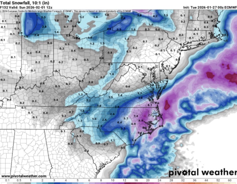
-

The “I bring the mojo” Jan 30-Feb 1 potential winter storm
NC_hailstorm replied to lilj4425's topic in Southeastern States
Euro goes neutral about 117-120 and the shortwave is further east.Not a whiff but the timing could be a tick better. -
The lp on 0Z Euro went from a 995 to a 983 stalled off NC coast in 6 hours - BUT 12 hours later deepens to 962mb moving east - weird solution and progressive flow that L near Minnesota is not a good signal with HP in southeast Canada - too far north
-
The only shred of hope I have is it actually gonna snow 30" on the Delmarva?
-
What? Your roof should be able to hold at least 3-4 feet of snow. You’ll be fine


