All Activity
- Past hour
-

2025-2026 ENSO
40/70 Benchmark replied to 40/70 Benchmark's topic in Weather Forecasting and Discussion
Gotta hope for a drastic flip later in the autumn....2007 pulled it off. -
2025-2026 ENSO
40/70 Benchmark replied to 40/70 Benchmark's topic in Weather Forecasting and Discussion
Anomalies of that magnitude will never be adequately signaled in long term guidance....obviously given CC said anomalies are usually warm rather than cold these days. -
Never had this many days of significant radiational cooling in a row since I’ve moved here in 2015. The conditions have also been so suitable to radiate that we hit the dewpoint before midnight and continue slowly dropping to sunrise. Overnight radiational fog has been a regularity right at the surface. It’s a common desert phenomenon that sustains vegetation; it’s doing wonders for my young grass and grass seed. The vegetation around here generally doesn’t reflect the severe lack of rain thanks to this; it looks more mild to moderate…
-
Yup, we are reduced to waiting for the weekly drought monitor for weather excitement. Should see an expansion of the red area.
-
2025-2026 ENSO
40/70 Benchmark replied to 40/70 Benchmark's topic in Weather Forecasting and Discussion
I think we'll see a month that is decidedly positive. -
0.94” here definitely over performed hrrr was out to lunch
-

September 2025 OBS-Discussion centered NYC subforum
jm1220 replied to wdrag's topic in New York City Metro
Radar not looking impressive. Probably waves of mist on stiff easterly wind for the most part here. -

2025-2026 ENSO
donsutherland1 replied to 40/70 Benchmark's topic in Weather Forecasting and Discussion
If one is looking for an idea of the warmest potential for any winter (month, season, or year) in the current climate regime (defined as the most recent 30 periods e.g. winters), one can come up with confidence intervals from a linear regression equation. A 1-in-1,000 year probability for the current regime would be the 99.9% confidence interval. For NYC, that value for a winter mean temperature is currently 44.8° (record is 41.6°, in 2001-02). The coefficient of determination for NYC is 0.545. Recently, though, some cities have seen months or even seasons breach this threshold e.g., July 2023 in Phoenix. -
46.0° Should be an exciting drought monitor tomorrow.
-
45F for the low, drought continues...where was this nice weather in the spring!
-

September 2025 OBS-Discussion centered NYC subforum
bluewave replied to wdrag's topic in New York City Metro
Friday could be the warmest day at JFK since 8-25 since we are finally getting an offshore flow. Moderate dewpoints and steep low level lapse rates. So mid 80s are possible from the forecast soundings.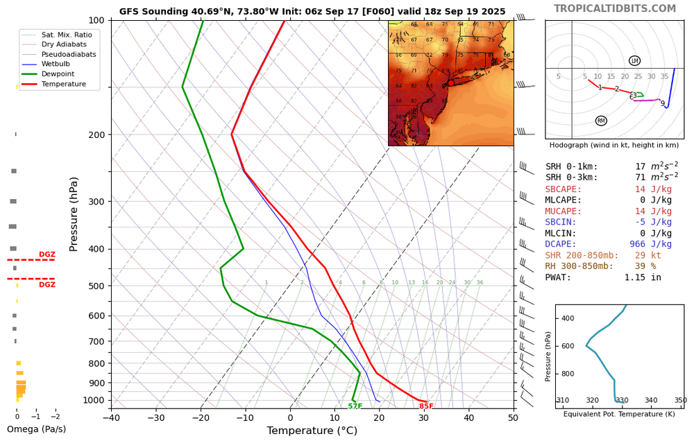
-
Poolesville mesonet site has recorded nearly 1" of rain in the past 24 hours, yet the 4" soil moisture values have barely moved. Plants must really be soaking things up.
-

Central PA Summer 2025
Mount Joy Snowman replied to Voyager's topic in Upstate New York/Pennsylvania
Low of 57 with a very solid .53” in the gauge. Could really hear it coming down through the night at times. -
43F for the overnight low here BOS at -2.2F MTD ORH up to -0.8F should be AN soon
- Today
-
The projected pattern for late month and early October isn’t just warmer than normal….it’s also dry as a bone. If this is correct, we will be in full fledged drought conditions in October
-

Invest 92L--90% two day, 90% five day odds
NorthHillsWx replied to WxWatcher007's topic in Tropical Headquarters
The GFS brings it back to life a little more on the 6z but one thing is beginning to become apparent and that is this system likely struggles until the recurve due to a combination of large size, shear, and an area of SAL it will be interacting with. To me this was a given to become a MH given modeling over the past few days. Now I am not so sure. -
Nice sunrise too.
.jpg.d54e81e7b12bbe879a452aca6e84b1fc.jpg)
-
0.74" event so far
-
We never really know what the warmest potential is for any winter until it actually gets underway. There were no reliable forecasts prior to December 2015 suggesting the +13 and warmer than many Novembers for the Northeast. The 2016-2017 winter also gave no early model indication of how warm it would be. Same for the 2019-2020 winter. There wasn’t a seasonal forecast issued prior to December 2021 forecasting a +13 for DFW. Plus we didn’t get any indication ahead of the 2022-2023 winter from the models that there would be such a deep trough in the West. None of the models had the magnitude of the warmth for the 2023-2024 winter ahead of time. But there were indications as early as the spring and summer I was discussing ahead of time that there were warmer risks to the forecast due to how warm the WPAC was for an El Niño. But the magnitude of the warmth became extreme since we had multiple +10 months in a row. This is because nearly every winter since 2015-2016 some portion of the CONUS has experienced a +10 or warmer month. The location and magnitude of the warmth are never forecast much in advance. Dec…2015….NYC….+13.3 JAN…2017….BTV…..+11.0 FEB….2017….ORD….+10.3 FEB…..2018…ATL….+10.6 FEB….2019…MGM….+10.5 JAN….2020…YAM….+9.8 DEC….2021….DFW….+13.2 JAN….2023….DXR….+12.3 FEB….2023…..SSI…..+9.8 DEC….2023….INL…..+15.8 FEB…..2024….FAR…..+17.5 DEC….2024…..LND…..+11.3
-
Invest 92L--90% two day, 90% five day odds
NorthHillsWx replied to WxWatcher007's topic in Tropical Headquarters
I’m a little surprised they designated this a depression overnight. Can anyone else find a center? First visible images seem to suggest a sharp wave axis but no discernible center. Convection is also not well organized. Hmmmm -
2025-2026 ENSO
donsutherland1 replied to 40/70 Benchmark's topic in Weather Forecasting and Discussion
It seems quite bizarre, especially with the embedded simulated radar image from a snowstorm that almost certainly won't be equaled during any of our lifetimes in the Deep South. -
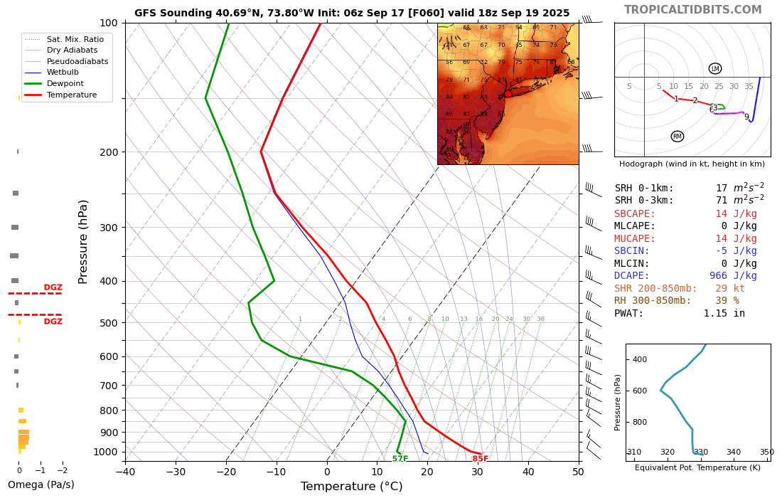
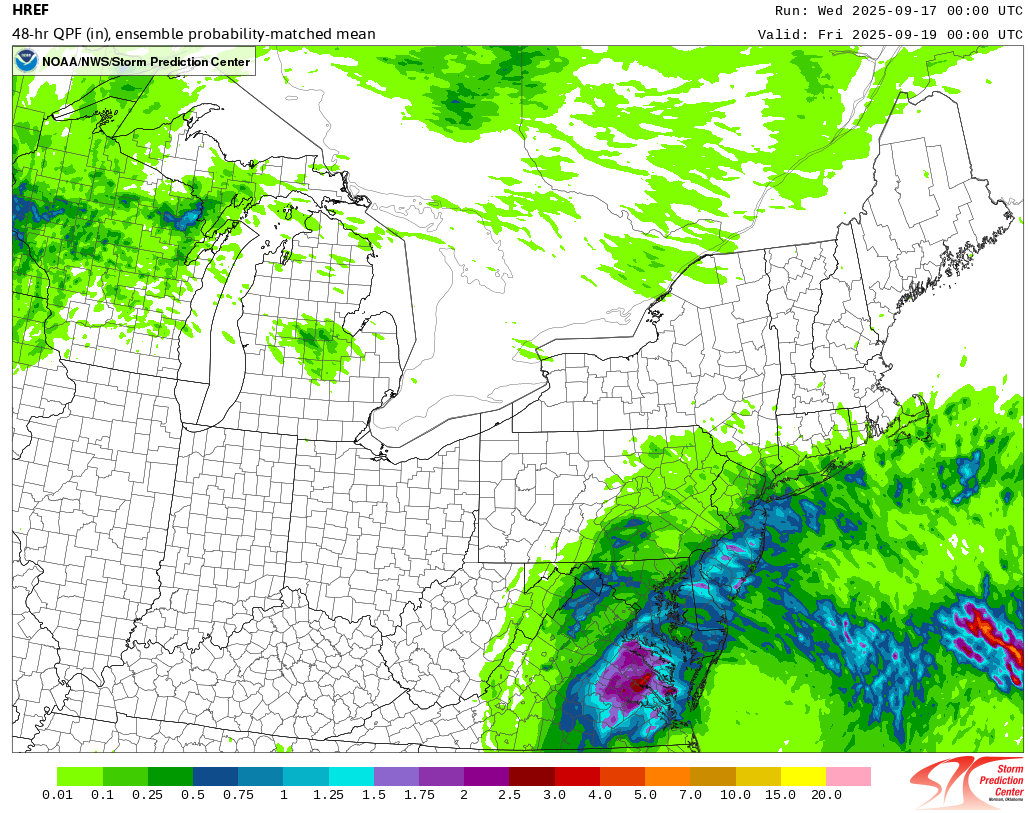
September 2025 OBS-Discussion centered NYC subforum
donsutherland1 replied to wdrag's topic in New York City Metro
Latest HREF: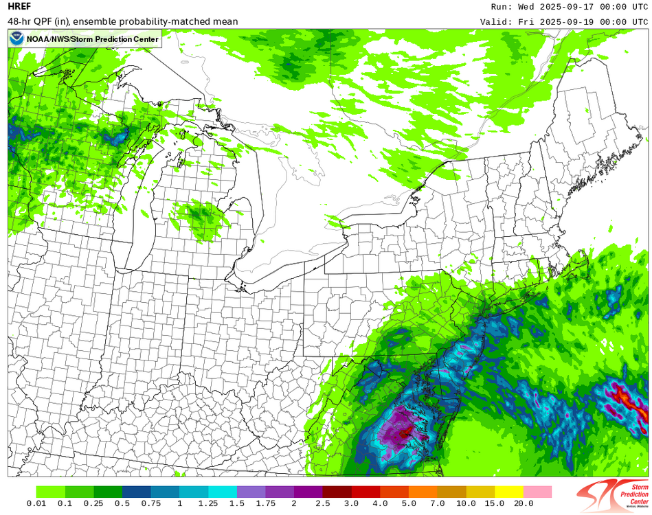
-
We are in serious need of rain if we do not want to slide into a drought. We are sitting, 17 days into September, at 0.16” if rain for the month and going back to August 15 we have only received around 1/2” total. When I say it’s gotten dry that is an understatement! No rain in forecast either. We look likely to finish out September with under 1/2” total rainfall (possibly under 1/4”) which, including the second half of August, would leave us under 1” for the last month and a half. Not good
-
On and off showers rotating in from the east overnight. 0.85"
-
man i love this fall-ish rainy morning


.thumb.png.4150b06c63a21f61052e47a612bf1818.png)