All Activity
- Past hour
-

26th-27th event, coming at us like a wounded duck.
RUNNAWAYICEBERG replied to Go Kart Mozart's topic in New England
Then definitely go with that. -

Central PA Winter 25/26 Discussion and Obs
Mount Joy Snowman replied to MAG5035's topic in Upstate New York/Pennsylvania
Open ‘er up! -

E PA/NJ/DE Winter 2025-26 Obs/Discussion
RedSky replied to LVblizzard's topic in Philadelphia Region
50F! -
TWC backed off some, obviously...
-
Yes. HREF also in line with a moderate snowstorm.
-

26th-27th event, coming at us like a wounded duck.
weatherwiz replied to Go Kart Mozart's topic in New England
If you look at where models (NAM, GFS, Euro) have the 700mb warm front...the NAM actually I think makes sense with how far north and east it has the banding. I think the area of strongest frontogenesis on the 12z RGEM would be northeast of where it has it -

26th-27th event, coming at us like a wounded duck.
Sey-Mour Snow replied to Go Kart Mozart's topic in New England
Yes only thing is HRRR looks spot on with other globals NAM doesn’t -

26th-27th event, coming at us like a wounded duck.
weathafella replied to Go Kart Mozart's topic in New England
We’ll find out soon. It’s the first usable 18z given the fact that HRRR beyond 12 hours is not useful usually. -
I am not worried about that area. I don’t live there.
-

December 2025 regional war/obs/disco thread
Chrisrotary12 replied to Torch Tiger's topic in New England
Closing the shades after tomorrow's flurries. All storms track to our NW after this. -
Stop. You do this with every storm. Have a drink
-
wasn't this a full whiff yesterday?
-

26th-27th event, coming at us like a wounded duck.
MJO812 replied to Go Kart Mozart's topic in New England
Rrfs gives nyc 6-10 inches. -
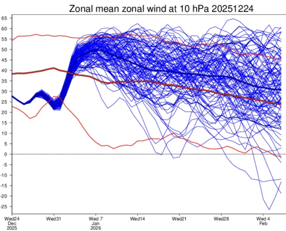
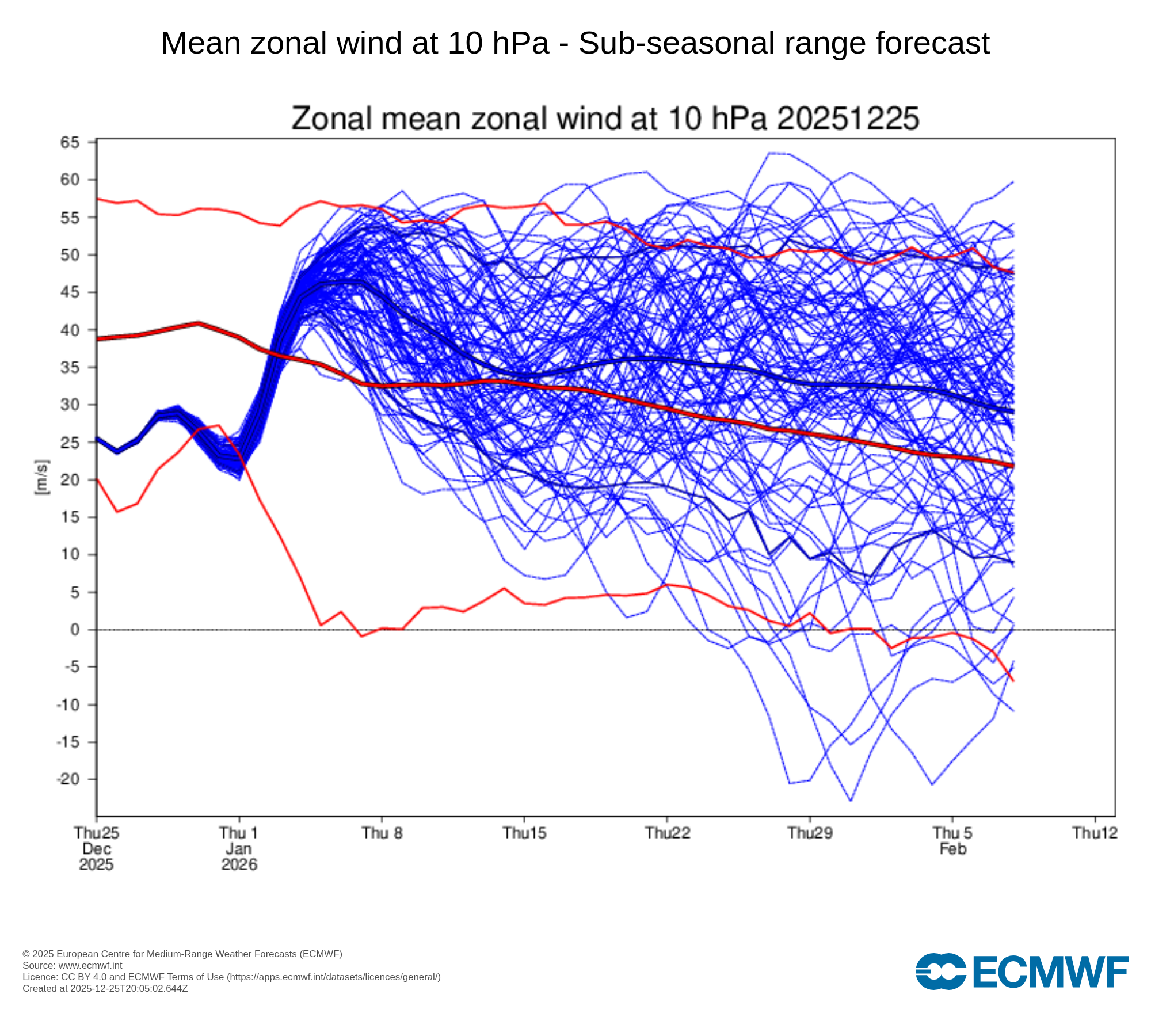
This is why watching SPV forecasts very far out at all will bite you, if you're predicting by using them. Make note of trends like a new weakening verses yesterday & many more members after that versus yesterday. Changes a lot & has since NOV. yesterday's

-
26th-27th event, coming at us like a wounded duck.
Sey-Mour Snow replied to Go Kart Mozart's topic in New England
3km and RRFS are much further south like the other models, NAM is drunk -
26th-27th event, coming at us like a wounded duck.
MJO812 replied to Go Kart Mozart's topic in New England
3k is further south. Weird how both nams are different. -
Swatting wasps away in the afternoon sun. Merry Christmas!
-
Leavenworth.....an underrated gem in the lower 48.
-
Amazingly beautiful out there. Merry Christmas!
-
18z Rrfs 6-10 inches for the NYC area
-
26th-27th event, coming at us like a wounded duck.
weathafella replied to Go Kart Mozart's topic in New England
NAM went way north. -
In my experience, if the NAM shows sleet inside 48 hours, even if it's an outlier compared to other guidance, it absolutely can happen and often does. There is a good chance this run is north of the final outcome. But I really don't think the trend should be dismissed. The silver lining is a 2-5" snowstorm is possible for the metro even in the NAM scenario.
-
.
-
3k Nam way further south
.thumb.png.d6bd9d57578820cab4a19bdc12333ef7.png)
-
nam is getting discontinued for a reason it hasn't hit a home run since January 26th 2016


.png.de3df90860d29ca42a7c383949872b71.png)