All Activity
- Past hour
-
Yup these storms have some strength to them especially getting better organized out of the west.
-
Yeah, we kind of lucked out with the late February snowstorm. There was just enough cold air for that to happen. If it happened even a few days later, it would have been a completely different story. There just isn't any cold air for a snowstorm right now. I mean, we just had 4 days in the 70s, with 2 of those in the 80s last week. Any snow (if it does happen) will be just like last Thursday: brief and will not accumulate.
-
This was fun one to track: WHEN LOOKING AT REGIONAL PRESSURE TRACES OVER THE PAST 24 HOURS, THE PATH OF THE CENTER OF THE LOW HAS BEEN ON THE VERY SOUTHERN END OF ENSEMBLE CLUSTER PATHS WITH A NOTABLE SOUTHERN TREND ESTABLISHED IN EACH SUCCESSIVE ENSEMBLE MEAN FORECAST OVER THE PAST FOUR SUCCESSIVE RUNS. AS A RESULT, THE DEFORMATION "COMMA HEAD" REGION IS VERIFYING SOUTHEAST OF ENSEMBLE GUIDANCE, AND IS LARGELY CENTERED FROM THE MISSISSIPPI RIVER TO INTERSTATE 39. AN INTERESTING NOTE THIS MORNING IS THE CLEAR PASSAGE OF SEVERAL MESOSCALE GRAVITY WAVES THROUGH THE DEFORMATION SHIELD, WHICH WAS WELL ADVERTISED BY CAM GUIDANCE 24 HOURS AGO. EACH WAVE WAS MARKED BY A LOCAL INCREASE IN SNOWFALL RATES AND WAKE SUBSIDENCE, AS WELL AS LOCALLY HIGHER WINDS (OVER 60 MPH IN SOUTHEASTERN WISCONSIN).
-

2025-2026 Fall/Winter Mountain Thread
Buckethead replied to Buckethead's topic in Southeastern States
Severe thunderstorm warning just went up with a tornado possible tag.<br /><br />Sent from my Pixel 10 Pro using Tapatalk<br /><br /><br /><br />[img]https://uploads.tapatalk-cdn.com/20260316/98aaec8851079d23deb70d4ee6e1a60a.jpg -
 Absolutely pouring in that thin line over the beltway.
 -
Already 0.6" overnight. We'll see what today holds.
-

Phoenix Experiences Warmest February and Winter on Record
donsutherland1 replied to donsutherland1's topic in Climate Change
Yes. Only once in March 26, 1988 -
 Morning discussion from LWX DISCUSSION... KEY MESSAGE 1...A strong cold front pushes across the forecast area Monday, bringing gusty winds and potential for severe thunderstorms capable of producing significant damaging winds and tornadoes. A possibly high-impact severe weather event may unfold across the Mid-Atlantic region today, especially during the afternoon to evening hours. The Storm Prediction Center has maintained the Moderate Risk (Level 4 out of 5) area which extends from east of the Blue Ridge Mountains to the Chesapeake Bay. The one exception to this is northeastern Maryland which is in an Enhanced Risk (Level 3 out of 5) given the cooler bay waters could weaken approaching convection. The early morning surface analysis depicts a stout cyclone racing across northern Indiana which is accompanied by a squall line which has jumped out ahead of the cold front. Closer to the local area, a wavy frontal zone arcs from just south of St. Marys County westward across Richmond and back into southern West Virginia. While surface wind vectors are out of the east, the primarly low-level steering flow is from the south. Light overrunning showers continue to lift northward through the region. The combination of weak forcing and ample low-level stability is yielding rather scant rainfall totals, generally averaging under 0.10 inches. Otherwise, low stratus will remain a fixture in the early morning forecast which comes with temperatures in the 50s to low 60s. Ample poleward flow within the warm conveyor belt should help push this warm front north of the Mason-Dixon Line by just after daybreak. While the 00Z IAD sounding is now outdated, its vertical wind profile indicates precisely why the severe threat has a high ceiling today. The 0-6 km wind fields were characterized by substantial cyclonic turning of the winds with height, coupled with surface backed flow. In the net, this sounding yielded a 0-1 km storm-relative helicity of 506 m2/s2 which is off the charts. However, the profile lacked any instability, particularly headed toward the more stable overnight hours. Despite only being 12 to 18 hours out, the 00Z high-resolution model suite continues to show timing and evolution differences. There are a couple of areas to keep a close eye on: (1) The squall line racing across eastern Kentucky/Ohio right now (331 AM) and (2) The low stratus deck in place. In terms of recovery, this low cloud deck will need to erode to allow the 500 to 750 J/kg of surface-based CAPE to materialize. All signs point toward gradual erosion of these stratus clouds, but it may take until after the noon hour. Even then, these could just be breaks in the clouds. Any additional insolation through the day will help increase instability in the presence of substantial vertical shear (0-6 km values around 55 to 65 knots). The other aspect of the forecast references the upstream squall line. How long this holds on and its cirrus canopy overspreading the region will also play some roles in how convective development evolves. With the degree of deep-layer shear in place, any of the pre- frontal discrete cells will pose a risk of becoming a supercell. These would be most conducive to producing a tornado, particularly if the enlarged 0-1 km and 0-3 km hodographs hold as true as forecast soundings depict. However, some of the high-resolution guidance show a slew of cells firing up at once which would favor more competition amongst them. This would diminish the tornado risk as multicell convection dominates. At the same time, another squall line is likely to form off the higher terrain this afternoon. While the vertical shear vector does not align perpendicular to the forming line, enough angle between the two should favor evolution into a quasi-linear convective system (QLCS). These are prone to producing spin up tornadoes along any kinks in the line. Where this line bows out is where the 70 to 80 mph wind gust possibliity will be maximized. All of this slides eastward at a fairly hefty speed, perhaps 40 to 50 mph. Severe convection is expected to near the I-95 corridor during the evening rush hour before exiting the Chesapeake Bay by the early/mid evening hours. Some weakening is possible east of I-95 as the system begins to ingest the colder Chesapeake Bay waters. Outside of convection, conditions will be gusty today as a deep surface low tracks across the Great Lakes. Strengthening southerly flow may gust to 30 to 40 mph, with gusts closer to 50 mph in the mountains. Additionally, this also could occur in northeastern Maryland given this region stays in the warm sector longer and perhaps free of convection. Wind Advisories are in place across these areas which may see 50 mph gusts outside of any convection. Eventually a powerful cold front will usher in a cold and blustery air mass to the region. Gusts may be strong enough in the mountains to support additional Wind Advisories. All and all, ensure everyone has multiple ways to receive hazardous weather information from the National Weather Service. When it comes to Tornado and Severe Thunderstorm Warnings, know where your safe place is and remain there until the storm has moved through and alerts have ended.
 -
Looking forward to flooding and an updated moderate drought map on Wednesday.
-
will be curious how much if any snow if left in the mountains obviously should be plenty based on the time of year
-
tons of deep standing water around the northside making things messy for the am commute spring leak out set to be lush af again blessed
-
.thumb.jpg.6a4895b2a43f87359e4e7d04a6fa0d14.jpg)
Central PA Spring 2026 Discussion/Obs Thread
Yardstickgozinya replied to Voyager's topic in Upstate New York/Pennsylvania
Highlight Changed Discussion -- 049 FXUS61 KCTP 160905 AFDCTP Area Forecast Discussion National Weather Service State College PA 505 AM EDT Mon Mar 16 2026 .WHAT HAS CHANGED... * Wind Advisories extended across northern PA and issued east of US-15 to account for gusty pre-frontal winds this afternoon. * Added details about timing of multiple rounds of showers/storms this afternoon. * Issued Winter Weather Advisory for Laurels & Northwest Mountains tonight for a thump of snow behind the cold front. && .KEY MESSAGES... 1) Gusty winds continue through this afternoon ahead of a cold frontal passage. 2) Multiple rounds of showers and storms will bring an Enhanced Risk of severe weather this afternoon and evening, with damaging winds and a few tornadoes as the primary threats. 3) Sharply colder temperatures arrive this evening with a thump of heavy snow possible across the west, and the chilly weather hangs around through midweek. && .DISCUSSION... KEY MESSAGE 1: Gusty winds continue through this afternoon ahead of a cold frontal passage. An impressive wind field continues to overspread Pennsylvania this morning and gusty south winds are expected throughout the day. Locations to the north and west of any steep terrain will continue to experience the strongest wind gusts during the day today, with sustained winds of 15 to 25mph and gusts 30 to 45 mph expected. A Wind Advisory remains in effect for the northern tier through early this afternoon, and then a Wind Advisory will go into effect for locations east of US-15 this afternoon through the evening. Note that gusty winds are expected across the entire area today and any showers or storms will tap into a very strong wind field aloft, bringing locally enhanced wind gusts. KEY MESSAGE 2: Multiple rounds of showers and storms will bring an Enhanced Risk of severe weather this afternoon and evening, with damaging winds and a few tornadoes as the primary threats. The Storm Prediction Center has continued with their Enhanced Risk (Level 3 out of 5) today. There appear to be two distinct rounds of rain that will cross the region. The first will be a pre-frontal line of storms that are currently crossing eastern Ohio and will get into our western counties (Warren/Somerset) between 9 and 10AM. As this line moves across the Commonwealth, it will encounter increasing amounts of instability (500-1000J/kg of MLCAPE) and intensify. The line is not currently producing any lightning, but lighting activity should commence by late this morning as it crosses the I-99 corridor. Damaging winds will be the primary threat with this line of storms, but a favorable low level wind profile with ~200 m2/s2 of 0-3km SRH will be sufficient for tornadoes along any portions of the line that develop kinks or discrete elements with embedded supercells. The second round of concern is when the surface cold front crosses the region. Although most of the instability will be absorbed by the first batch of storms, a potent isallobaric pressure fall/rise couplet will provide plenty of lift to produce a narrow cold frontal rainband. With 50+ kt winds just above the surface, it won`t take much to mix down strong to damaging winds. This line of rain and winds likely won`t have any lightning with it, but the wind will pack a punch as cold air pours in behind it. The cold front and associated damaging wind threat will clear our eastern counties by 10 or 11PM. QPF will be 1 to 1.5" for locations east of the I-99/US-15 corridor, and isolated 2" amounts are possible at higher elevations in Schuylkill and Sullivan County. Antecedent dry conditions should preclude any major flooding concerns, but ponding on roadways is a real possibility. If you have outdoor plans on Monday afternoon and evening, be sure to monitor the weather and consider changing your plans. KEY MESSAGE 3: Sharply colder temperatures arrive this evening with a thump of heavy snow possible across the west, and the chilly weather hangs around through midweek. This evening, once the surface cold front pushes through, colder air should rush in. At issue is how much steadier precipitation will linger behind the boundary. Given favorable upper jet placement and the probability that some wrap-around moisture will get steered into the Commonwealth, there is the potential for a quick 1-4" of snow in western portions of the state. HREF probabilities of 1" per hour snowfall rates are impressive and a several hour period of thumping snow are possible in the Laurels and northwest mountains. The latest WPC Winter Storm Outlook, which depicts probabilities of Winter Storm Warning level snowfall amounts, paints 30-50% probabilities from Somerset north to Warren/McKean/Potter County with a few pixels over 50% in McKean County. Although Warning level amounts are unlikely, the combination of favorable lift, heavy snow rates, and onset after sunset lead to confidence in at least Advisory level amounts/impacts. A Winter Weather Advisory is in effect from 21Z/5PM today through 06Z/2AM Tuesday for the northwest counties. The Advisory will continue through Tuesday afternoon (in collaboration with PBZ and LWX) in Cambria and Somerset County for lingering upslope snow showers. WATCHES/WARNINGS/ADVISORIES... Wind Advisory until 2 PM EDT this afternoon for PAZ004>006- 010>012-037-041. Winter Weather Advisory from 5 PM this afternoon to 2 AM EDT Tuesday for PAZ004>006-010>012-017-018. Wind Advisory until 11 AM EDT this morning for PAZ017-018-024- 033. Winter Weather Advisory from 5 PM this afternoon to 5 PM EDT Tuesday for PAZ024-033. Wind Advisory until 11 PM EDT this evening for PAZ042. Wind Advisory from noon today to 11 PM EDT this evening for -
 How we looking? Bust or Legit?
 -
39/37 Rain. Temps stayed up all night as expected. Continued thaw and melting overnight of the of piles into 60 degree temps tonight should wipe it all out, outside of the parking lots.
-
Rain started 6am, 38F, .11 so far, dumping away!
-
 My temp is about 10° warmer than yesterday so at least I won’t be sitting in CAD all day
 -
Already .53” of rain, temp 45F. Remaining piles of snow will be gone after today
-
2025-2026 Fall/Winter Mountain Thread
Buckethead replied to Buckethead's topic in Southeastern States
Starting out at 53 this morning at 6 am. Sent from my Pixel 10 Pro using Tapatalk -
Wind seems far less than expected.
-
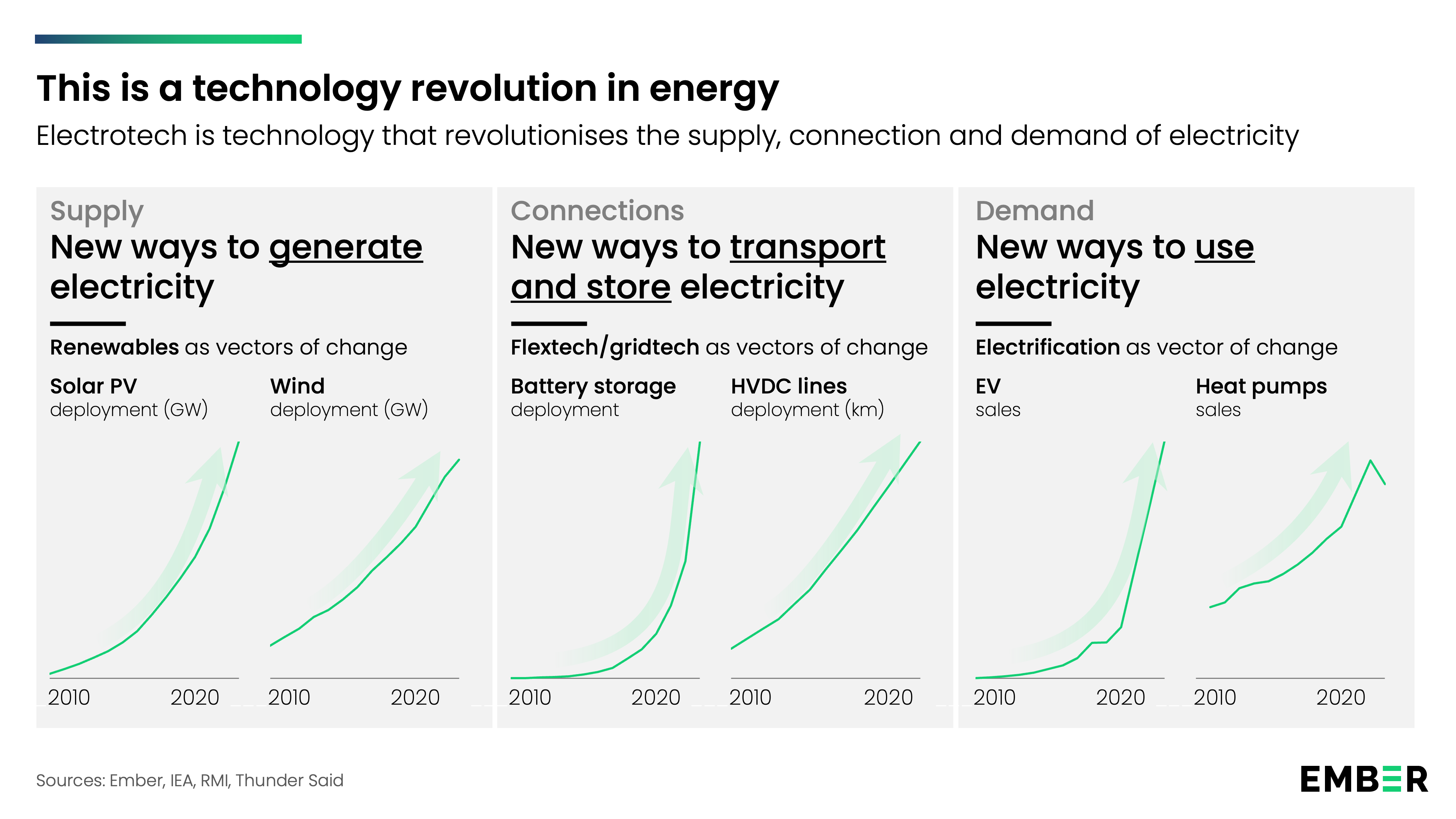
Most of the misleading information I see comes from fossil fuel and utility incumbents. For instance, per top link below, the "expense" of additional baseline power to backstop renewables is a fossil fuel fallacy. Renewables are becoming cheaper. Not everywhere and in every application; but, the long term trend is clear. In the future fossil fuels will be less competitive than they are today. Its not only renewables. A number of key energy technologies are on long-term improvement curves: batteries, EV, heat pumps etc. They work together to make energy generation, storage, transmission and use cheaper and more efficient. Meanwhile fossil fuel use is a mature technology; that uses a diminishing resource; and, that carries geopolitical and climate risk that isn't baked into the price. https://www.electrotech-revolution.com/p/renewables-allow-us-to-pay-less-not https://ourworldindata.org/cheap-renewables-growth https://www.electrotech-revolution.com/p/what-is-electrotech-and-what-will

-
Had some very heavy rains around 3am on/off for about an hour or so. Winds really blowing too.
-
Yup. Sweet radar look. Rare, it looks as modeled.
-
Nice defo
-
Anyone still hoping for arctic cold and snowstorms are trying to get blood from a stone at this point. This winter is cooked, been cooked. Done, over, finished, history, fat lady has sung and went home, stick a fork in it, bring down the curtain, it’s over Johnny, goodnight and goodbye, adios, dead, in the grave, RIP. A former winter…..
- Today
-
 Hoping these bust scenarios are true I don’t need any massive trees onto my house.
- 272 replies
-
- 2
-

-
- severe
- thunderstorms
- (and 1 more)