All Activity
- Past hour
-
 Not only that but no one is required to actually read each post. I can't be the only one who scrolls through the thread and read only the stuff that interests me at the time. Suns out, guns out here, 76/71.
 -
Have him commandeer the vessel and punch the core.

-
 It would be pretty weird to discuss hyper local temperature and precipitation trends in a general climate change thread. And departures don't mean shit anymore unfortunately when they're shifting so quick. Your -1 was considered slightly above normal just 5 years ago. I'd rather discuss overall monthly averages and rank them coldest to warmest according to the available record than use departure.
 -
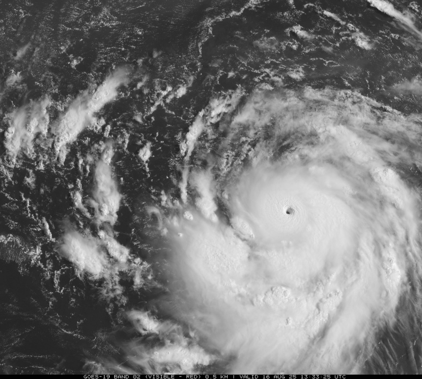
Due to Erin ACE is now rapidly rising with 2025 about to cross median for the date (of last 75) and should cross mean tomorrow. 2025 should reach top 20 for the date by Mon and top 15 or higher by Tue or Wed. @snowman19@mitchnick
-
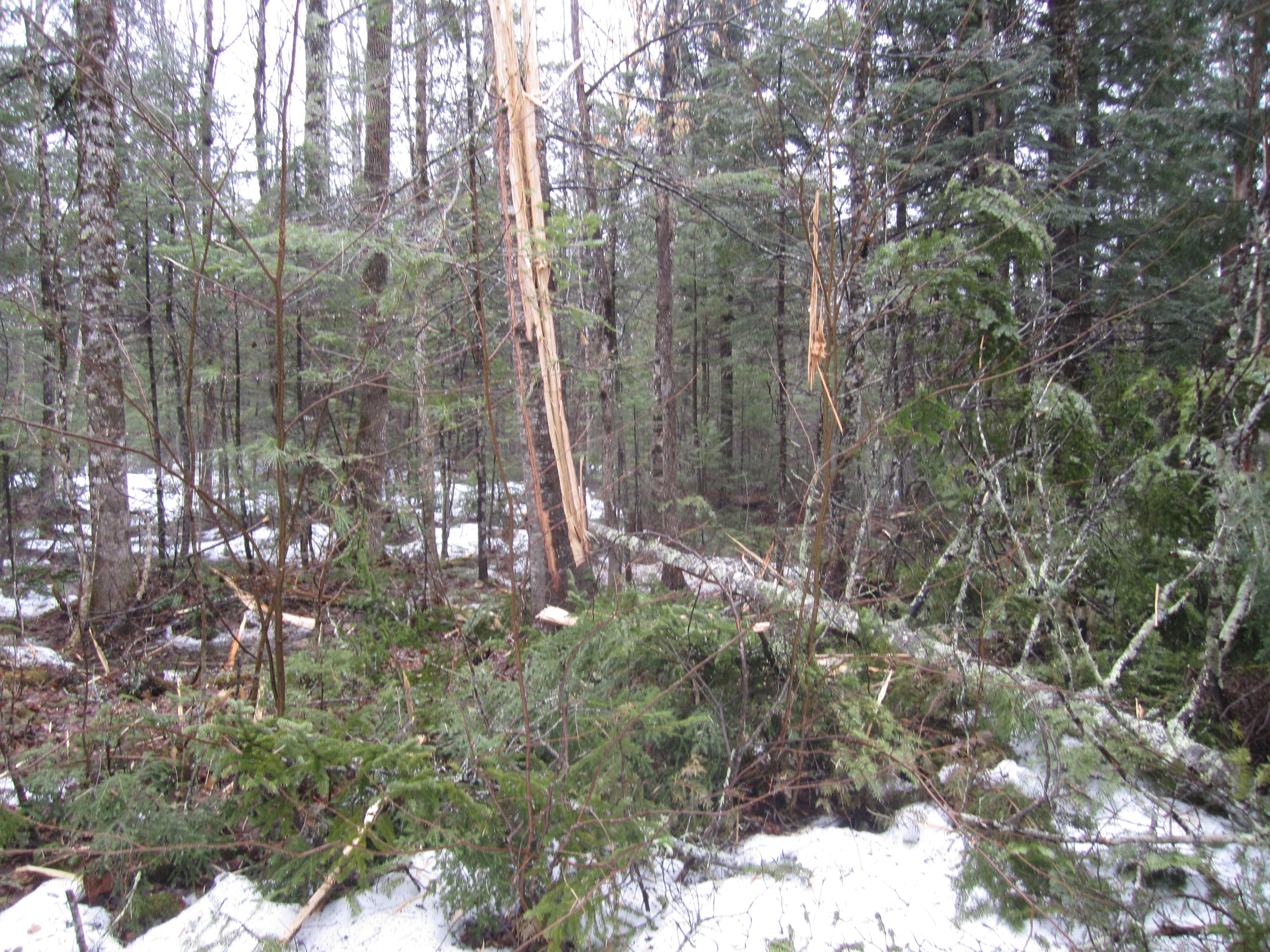
Nasty stuff. Pic below is from 3/27/21, a day after that 70-foot fir tree was blown apart, 55 yards from the house. In addition to traumatizing our yellow Lab mix (she was still shaking 45 minutes later), the strike ruined the connection between our generator and its dedicated panel. We only learned that in April when power went off. Genny started as usual but no transfer to the house. Technicians came and created a manual work-around (in rain turning to snow plus wind) so I could go down-cella, open the panel and flip the switch, until they could do a complete fix when the ground had thawed. Last winter the transfer again quit but I could do the manual switch; the tech came in the spring and had to replace the toasted auto-switch within the panel - probably had been compromised back in 2021 then finally died.

-
A friend is scheduled to go on a cruise to Bermuda later this week. Going to be close
-
 The hourly guidance showed mostly cloudy skies this morning. The clouds should break late morning/early afternoon yielding to partly sunny skies.
 -
You're free to post as much as you want. No one "controls" the thread.
-

Hurricane Erin - 145 mph - 935mb - WNW @ 20
BarryStantonGBP replied to BarryStantonGBP's topic in Tropical Headquarters
COME ON ERIN ALL OF WEMBLEY IS CHEERING FOR YA I -
Insane... imagine if the curve N never takes place and a WNW track continues. Get your sharpie out. It would change model reliance forever. Kinetic Energy FTW.
-
Lol, in my experience it's usually the other way around.
-

Hurricane Erin - 145 mph - 935mb - WNW @ 20
hawkeye_wx replied to BarryStantonGBP's topic in Tropical Headquarters
Now 922 mb extrap, 156 kts flight level wind. The inner core remains extremely tight, with no sign of any outer wind max beginning to develop. -
 Theres a whole forum for that. Thats a great place to discuss 30 year averages all over the place, not just here. You could link those discussions here anytime. Too many posts here about a warm day or a string of warm days this year are the fault of man made global warming especially this year, when we have 1 really above normal month since December. It’s just thin gruel in the context of the weather. global climate writ large, thats the right place because this is a hot year on a global scale. It’s just not that hot here this year in extremis over the last 40. So lets keep it to weather.
 -

Hurricane Erin - 145 mph - 935mb - WNW @ 20
NorthHillsWx replied to BarryStantonGBP's topic in Tropical Headquarters
FL was just shy of 150kts and with SFMR more than supportive of a 5 in both SW and NE eyewalls I personally think there’s enough for an upgrade. Min pressure tanking through the 920s also firmly supports it -
Problem is some of the same large scale forcing that causes cold now can cause an opposite reaction mid winter. That’s why snowfall in October has no correlation with a snowy winter.
-
 The GFS after 4 run cycles lost the tropical storm it had going into the Fl/Southeast in the 8/26 - 8/29 timeframe.
 -
Very photogenic fishfood...
-
Hurricane Erin - 145 mph - 935mb - WNW @ 20
NorthHillsWx replied to BarryStantonGBP's topic in Tropical Headquarters
That was a well-timed pass for the ages -
79 / 69 clearing a bit here.
-
Erin went from tropical storm to Cat 4 hurricane in 24 hours !
-
 No such thing as current weather in the obs thread, you should know this by now. 5 people control this thread and 1 awful met that said Erin was going into the Gulf.
 -
You say warm up, to what? '80s for a couple days or an extended stretch?
-

Hurricane Erin - 145 mph - 935mb - WNW @ 20
BooneWX replied to BarryStantonGBP's topic in Tropical Headquarters
Wow . -
Two days ago ... both the numerical teleconnectors, and the spatial-synoptic evolution, from all three ens means, looked "shot across the bow"-esque with the post August 20 range... As Scott also mentioned, there's a signal now to confined that more to just the third-ish week. The last week of the month reverses. I remember commenting a month ago, that I didn't like the August cool idea being floated at the time - memed to death by the usual X suspects - because there has been this leitmotif to lower Pacific NW heights. We may still end the month more marginal-AN. It'll be close. Regardless, whenever the models this season have showed more ridging in Pac NW outlooks, it was proven unstable. Within short days ... new height crash and troughs were digging down the B.C. coast. So long as that return base-state behavior is there, that's a non-linear indicator where the forcing the hemisphere wants to really be - it's your "correction vector". Here we are again... We'll see, but as of this moment starting to characterize as a mere pattern reset.
-

Hurricane Erin - 145 mph - 935mb - WNW @ 20
GaWx replied to BarryStantonGBP's topic in Tropical Headquarters
Due to Erin ACE is now rapidly rising with 2025 about to cross median (of last 75) and should cross mean tomorrow. 2025 could reach top 20 by Mon and top 15 by Tue or Wed.