All Activity
- Past hour
-
6Z GEFS has many east coast hits
-
low of 55
-
Can we get a “Ain’t happening James”
-
Most of the GEFS are west of the op
-
 nws nyc thursday 88 friday 85 saturday 86 what heatwave?
 -
6z GFS came west and bit and the 6z GEFS are taking a big shift back west.. not over
-
It’s over as usual
-
when has there ever been a heatwave in the northeast that lasted 2 weeks?
-
57/55 Another rare August morning
-
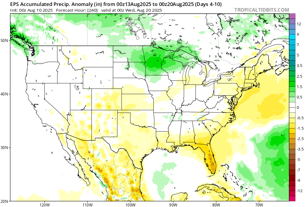
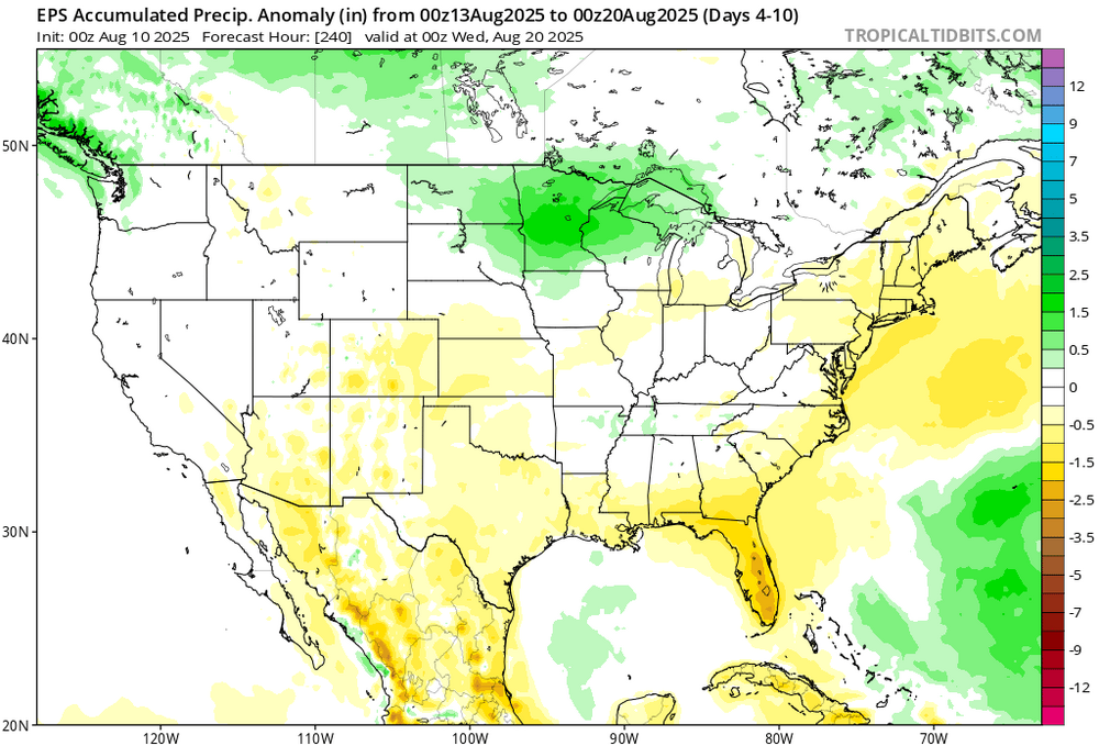
 The 0z guidance keeps the hurricane activity well off shore the week of the 18th. So we continue with the heat that week also now. Some earlier runs had a system in the Gulf with remnants streaming north through the Ohio Valley to our West. Now we get another heat dome. No undercutting low to our Southeast keeping it cooler with the first system. Dry heatwave pattern through the next few weeks
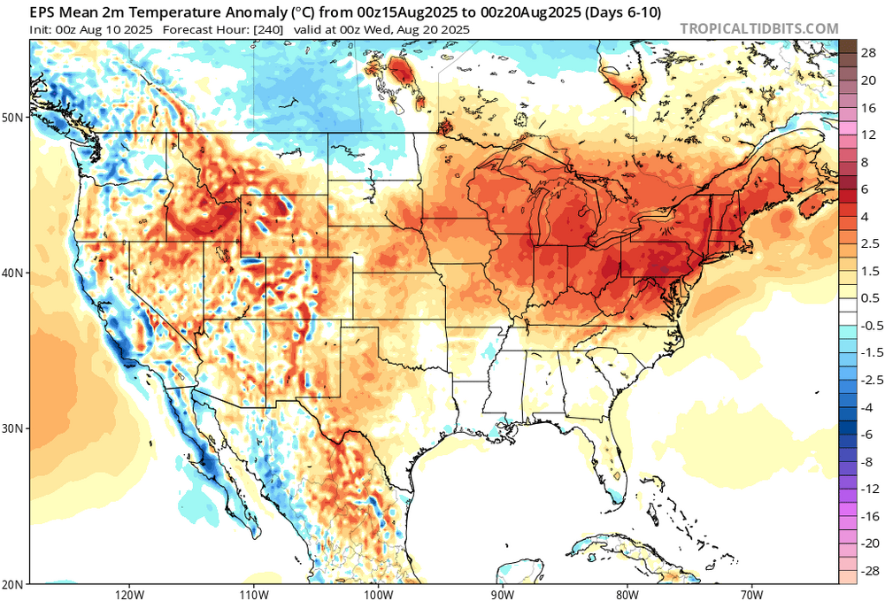
-
I think this Atlantic tropical season has tipped its hand….
-

Chester County PA - Analytical Battle of Actual vs. Altered Climate Data
chubbs replied to ChescoWx's topic in Climate Change
Yes UHI at the Philly airport is saturated. UHI is non-linear with population density. Per chart below, the biggest UHI effect comes with the initial urbanization. In addition there isn't much year-to-year or decade-to-decade change in the area near the airport. Minor building in the flat part of the curve isn't going to move the needle.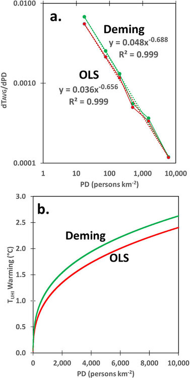
-

2025 Atlantic Hurricane Season
Bxstormwatcher360 replied to BarryStantonGBP's topic in Tropical Headquarters
The new euro has this coming up and shifting nw into new England. Still early obviously but a retreating high is dangerous for anybody on the coast north of cape may nj,landfall could be from there anywhere up to cape cod,ma.?? - Today
-
59/57 Got to be the last for a while.
-
Slight tick west.
-
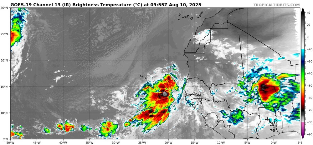
I can’t even remember the last time a tropical wave looked this good so close to Africa
-
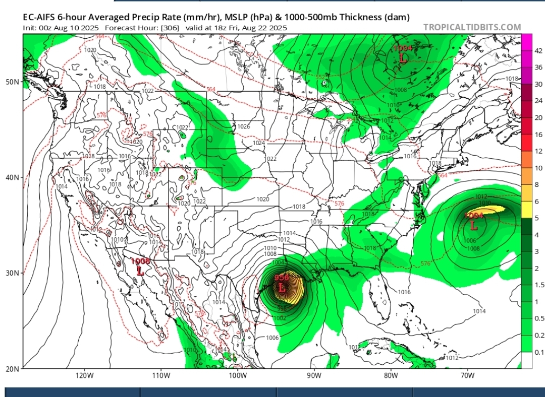
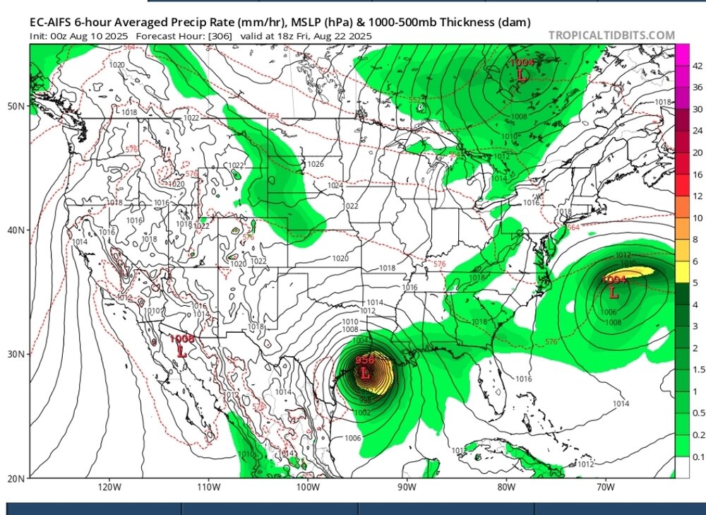
0z Euro and GFS OTS.. GEFS OTS .. EPS says the east coast watches but many OTS. still a long way to go with this one and it will change mant times. EURO AI in the Gulf and hits Texas
-
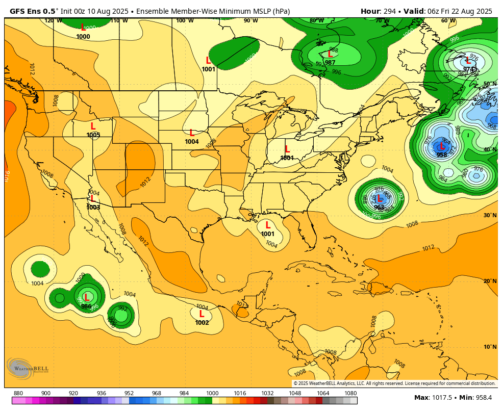
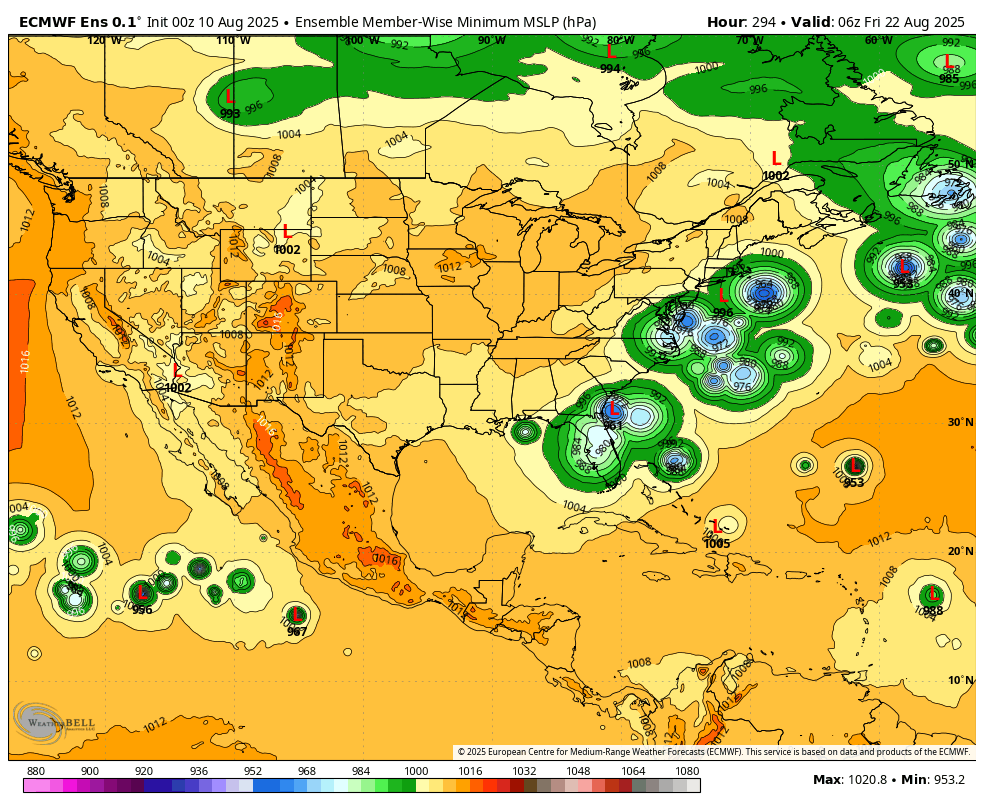
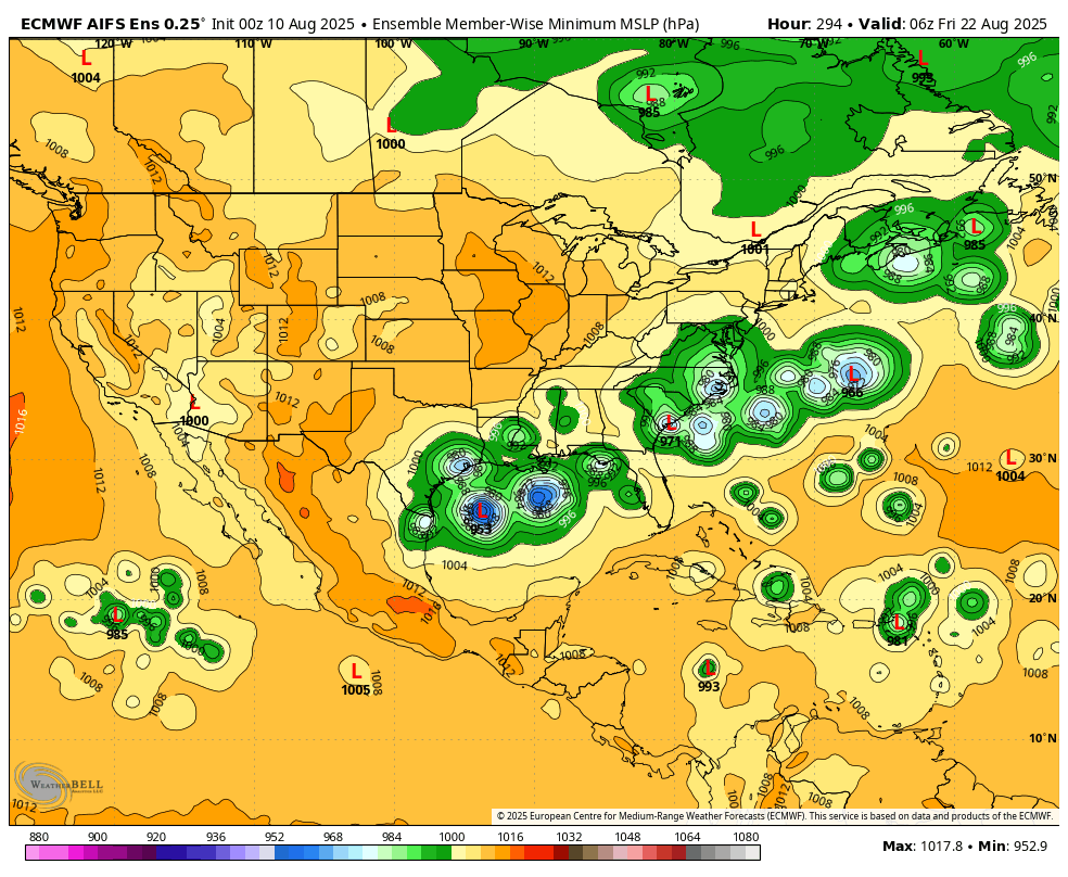
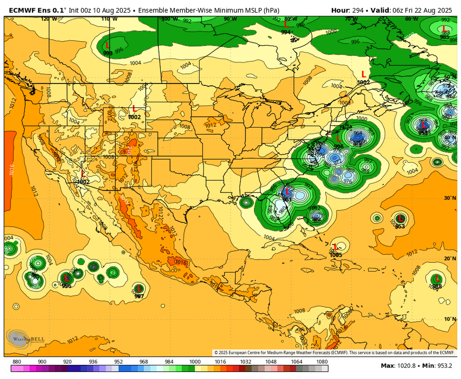
WB 0Z ensembles in 12 days at 6Z Friday 22nd: GEFS a fish storm. EPS has a few members taking a more southern route. AI is on to something or got drunk last night and has members from Texas to Mid Atlantic.


-
1. Eastern Tropical Atlantic (AL97): A broad area of low pressure, associated with a tropical wave, is producing a large area of disorganized showers and thunderstorms just to the east and southeast of the Cabo Verde Islands. Environmental conditions appear conducive for gradual development of this system, and a tropical depression is likely to form by the middle to latter portion of this week while moving west-northwestward at 15 to 20 mph across the eastern and central tropical Atlantic. Locally heavy rainfall and gusty winds are possible today and Monday across portions of the Cabo Verde Islands. * Formation chance through 48 hours...low...10 percent. * Formation chance through 7 days...high...70 percent.
-
Holy shit! I was driving back to Kenosha from Milwaukee during the tail end of it. Accidents everywhere along 94 from downtown and south. In a 15mi stretch I must have seen 10 accidents if not more. Lanes suddenly blocked with impassible standing water, underpasses flooded (passible but had to idle through), cars spun out and blacked out in the middle of the highway, visibility was absolute garbage… that was a sketchy drive and I definitely shouldn’t have been out there, but as a weather nerd it was still pretty cool to see. Didn’t look like any of the accidents were too serious but none of them had emergency crews on scene yet, so there were just random cars sitting in the middle of the road or crashed against the barriers. The CG was very impressive as well. Glad to be home safely in my bed.
-

2025-2026 ENSO
so_whats_happening replied to 40/70 Benchmark's topic in Weather Forecasting and Discussion
Pick your poison a week plus out you either get the threat of TC landfall and warmth over much of the East or you get cool and storms get scooped up out to sea. -
The 0Z UKMET for some reason doesn’t classify this as a TC. I’d like to see the WxBell or weather.us maps once they’re released to see why. From what I can tell on Pivotal, there still is a sfc low. The 0Z Euro goes near Bermuda.
-
-
Wow, very impressive. I wonder if it might be upgraded to a flash flood emergency?
-
Seems Milwaukee (especially the south side) is really getting a shellacking.