All Activity
- Past hour
-

E PA/NJ/DE Winter 2025-26 Obs/Discussion
PhiEaglesfan712 replied to LVblizzard's topic in Philadelphia Region
Yeah, those north and west got the snow in 2020-21. The sharp cutoff south and east showed the warmer storm tracks that season. However, in many of the areas south and east that had below normal snowfall in 2020-21, they did better in 2021-22, when many of the storm tracks were colder and closer to the coast in January 2022. -
Noon report. Have 2.5 OTG, temp 31.5 DP 29.6 with light snow falling. Flakes have consistently gotten smaller in last hour, must be drying a bit upstairs.
-
Seems like some back building and development starting to occur in the lee. Radar will be an interesting watch for the next little bit.
-
I’d take dinkleshit.
-
It takes a lot to get you excited.
-

The Monday wintry event potential (12/8/25)
NorthHillsWx replied to GaWx's topic in Southeastern States
That didn’t take long, already mixing with snow. 50/50 rain snow mix id say -
I never claimed to be a teacher, and you definitely learned about sex. I'm just sorry you can't find a woman to use my sage advice.
-
sorry--poorly worded on my end. I meant to say that you would like it if it happened verbatim, but obviously its the GFS two weeks out lol.
-
35 more snow than rain now
-

December 2025 Short/Medium Range Forecast Thread
Daniel Boone replied to John1122's topic in Tennessee Valley
Snowing lt to moderate here and 35 degree's. -
Ok euro show some signs of life here and either show the Friday hit or the Sunday hit FFS.
-

Richmond Metro/Hampton Roads Area Discussion
chris624wx replied to RIC Airport's topic in Mid Atlantic
Looks like ORF is reporting -SN as of the last few OBS. Temps still around 37F -
I’m not here to run my post count up. I’m on here to learn, and I don’t think I’ve learned a single thing from your 13000 posts lol. .
-

December 2025 Short/Medium Range Forecast Thread
Carvers Gap replied to John1122's topic in Tennessee Valley
It appears the 12z GFS will have the anafront on Christmas Eve. Only 60 more runs to go. What could go wrong?! -
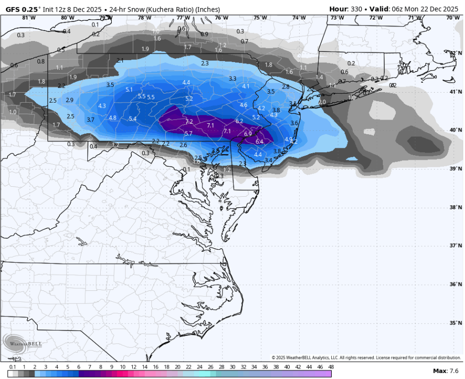
At hour 330? No that doesn’t get me excited.
-

December 2025 regional war/obs/disco thread
weathafella replied to Torch Tiger's topic in New England
Dinkleshit actually….2-5 gives warnings there. URGENT - WINTER WEATHER MESSAGE National Weather Service Wakefield VA 1013 AM EST Mon Dec 8 2025 VAZ060-061-066>069-079>083-513>516-082300- /O.CON.KAKQ.WS.W.0006.000000T0000Z-251208T2300Z/ Prince Edward-Cumberland-Lunenburg-Nottoway-Amelia-Powhatan- Brunswick-Dinwiddie-Prince George (including Hopewell and Petersburg)-Charles City-New Kent-Western Chesterfield-Eastern Chesterfield (Including Col. Heights)-Western Henrico (Including the City of Richmond)-Eastern Henrico- 1013 AM EST Mon Dec 8 2025 ...WINTER STORM WARNING REMAINS IN EFFECT UNTIL 6 PM EST THIS EVENING... * WHAT...Heavy snow. Total snow accumulations between 2 and 5 inches. * WHERE...Portions of central, east central, and south central Virginia. * WHEN...Until 6 PM EST this evening. * IMPACTS...Plan on slippery road conditions. The hazardous conditions could impact the Monday evening commute. PRECAUTIONARY/PREPAREDNESS ACTIONS... If you must travel, keep an extra flashlight, food, and water in your vehicle in case of an emergency. Call 511 for road information. -
yeah, you and @TSSN+ would like this

-
It’s wild the difference between downtown and Bon Air. The grass, trees, and elevated surfaces have been coated for over an hour here, even despite the small flake size. .
-
gotta love how the Canadian sticks its (middle) finger of snow-hole right through our region...

-
If my dick jokes were as constant as his complaining i would be an actual penis, but i hear you. I am far from a part of the main click, in fact i love when people hate me. Maybe stop lurking and start posting, drive by's are very rude.
-
Nobody said you're hurting or insulting anybody, you just have been complaining for year and years NONSTOP. I don't put anyone on ignore because it just gets quoted anyway. You're a good guy, just less complaining would be greatly appreciated.
-
Nothing like playing catch-up NWS Charleston! Have friends in Beckley that already have 3-3.5 from event. URGENT - WINTER WEATHER MESSAGE National Weather Service Charleston WV 1149 AM EST Mon Dec 8 2025 WVZ015-026-027-515>517-519-090200- /O.UPG.KRLX.WW.Y.0021.000000T0000Z-251209T0200Z/ /O.NEW.KRLX.WS.W.0011.251208T1649Z-251209T0200Z/ Kanawha-Boone-Clay-Northwest Raleigh-Southeast Raleigh-Northwest Fayette-Northwest Nicholas- Including the cities of Madison, Saint Albans, Bradley, Oak Hill, Charleston, South Charleston, Clay, Sophia, Beckley, Craigsville, Summersville, Fayetteville, Prosperity, Montgomery, and Birch River 1149 AM EST Mon Dec 8 2025 ...WINTER STORM WARNING IN EFFECT UNTIL 9 PM EST THIS EVENING... * WHAT...Storm total of 3 to 5 inches. Locally higher amounts on ridgetops. * WHERE...Portions of central, southeast, and southern West Virginia. * WHEN...Until 9 PM EST this evening. * IMPACTS...Plan on slippery road conditions. The hazardous conditions will impact the Monday evening commute.
-
always go with the less snowy solutions in my opinion. until it hits!
-
Can you repeat that? I didn't hear you the first time
-
Better to rely on the the various ensemble means at this point which show a less amplified solution due the fast flow and kicker lows coming into the West Coast at that time.