All Activity
- Past hour
-
you never know what your gonna get with radar in VT, it's the nature of the business
-

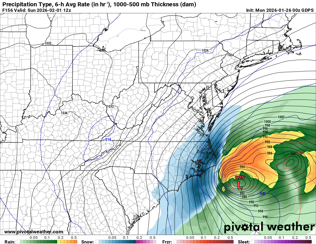
The “I bring the mojo” Jan 30-Feb 1 potential winter storm
chris624wx replied to lilj4425's topic in Southeastern States
If the NW trend doesn't go crazy, this is how we can get a big snow in NE NC/SE VA! (see last winter) -
 I need to move to you guys' part of town because I still just mist here. Below freezing now though, standing water is starting to freeze up
 -
Richmond Metro/Hampton Roads Area Discussion
chris624wx replied to RIC Airport's topic in Mid Atlantic
00z CMC is a deeper coastal low closer to the coast!
-
another long week of tracking

-
Really curious what the asking is gonna do in like 45 mins
-
.thumb.png.4150b06c63a21f61052e47a612bf1818.png) I can't go tomorrow but Berkshire East will be fantastic. Probably 16"-18" of dense needle fluff. Medium light with a silky feel but enough weight to feel and roll over like small waves.
I can't go tomorrow but Berkshire East will be fantastic. Probably 16"-18" of dense needle fluff. Medium light with a silky feel but enough weight to feel and roll over like small waves. -
 Cj time...my snow should end
 -
 My Ground and sidewalk is turning white.
 -
Funny that the KENX radar now shows a hole over us but it's snowing harder and with better growth than it has at any time this evening. Maybe the beam picks up snow differently depending on what altitude it's being generated?
-
16.5" snowfall as of 1130 in Methuen. 14 settled Storm depth
-
I took a blend of the Eduggs and the DonS models and assumed the NAM might be right about the sleet. But I think my broken abacus was a problem.
-
 Ripping solidly here. A plow went through and kicked up a cloud of powder. I've never seen anything like that lol.
 -
I'm just making sure I remember correctly, lol. It's been a long week. Keeps me interested for sure
-

The “I bring the mojo” Jan 30-Feb 1 potential winter storm
BornAgain13 replied to lilj4425's topic in Southeastern States
Good run incoming on the 0Z GEFS -
 Mountain at 8” on cam. Ripping snow.
 -
We’ve had some decent back building in E NY, still getting good returns out here along RT2. +SN still But yeah, the heavy stuff won’t last too much longer.
-
Snowgrowth in Rochester VT has improved dramatically. Snowflakes are casting shadows as they fall. The current rate is not extraordinary, probably about 1"/hour, but it will pile up quickly if it lasts as long as forecast. We've got about 7.5" so far. Killington/Pico/Sugarbush webcams look good
-
Let’s see what euro / euro ai have to say. We are at D6 after all. Not far from euros wheelhouse and the AI does pretty well at this range. LONG way to go, but it’ll be pretty encouraging if the euro holds its 18z idea generally
-
 Yeah wind is backing a bit which is a better trajectory here.
 -

Central PA Winter 25/26 Discussion and Obs
MAG5035 replied to MAG5035's topic in Upstate New York/Pennsylvania
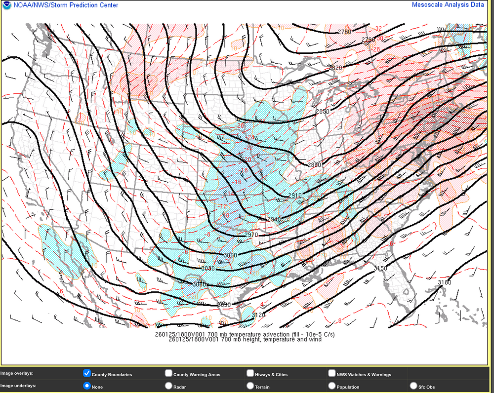
Considering we had the kind of mid-level pattern that we did for this storm, I’d say we did extremely well. Here’s 500mb heights and anomalies during the height of the storm today at the 18z initialization of the Euro. And Mesowest 700mb heights and temp advection at 18z today. This drove the mix line and the NAM ended up handling that the best. No closed 700mb low and the 700mb trough was aligned way west. Weaker secondary surface development to the coast wasn’t going to affect this issue. The fact that we had a forum wide warning event with widespread double digits while also being about as cold as you get at the surface for a synoptic event out of the Gulf is pretty remarkable with an alignment like that. At the end of the day this storm was mostly a moisture charged overrunning event with a very strong arctic air mass in place.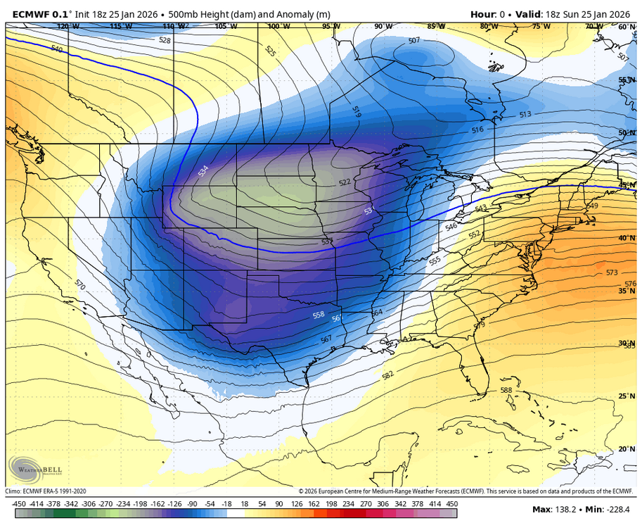
-
CF sinking south. Inside 128 now.
-
Seems lighter now but we had gusts near 50.
-
 Ocean enhanced bands along eastern MA coastline about to take center stage…
 -
Yes exactly. We were initially rooting for a phase out west quick but then it became too quick and too far west. I wouldn't have brought that analysis up here if I didnt think it had merit.