All Activity
- Past hour
-
How much you want to bet I get over 2"?
-

Winter 2025-26 Medium/Long Range Discussion
DocATL replied to michsnowfreak's topic in Lakes/Ohio Valley
Not even and inch of slop on grass. -
Winter 2025-26 Medium/Long Range Discussion
DocATL replied to michsnowfreak's topic in Lakes/Ohio Valley
Should be interesting for Wisconsin and Michigan for sure. Multiple opportunities. -
I suspect that would wash out with stronger lift.
-
Lower thermals not to an issue here at 31.8 All about the lift.
-
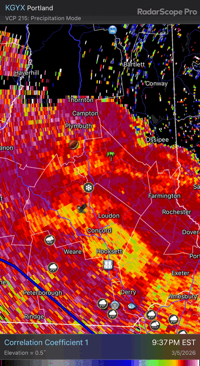
Looks like that sleet line is hanging tough north of MHT. Good luck to the weenies staying up for this.
-
-
Still a lot of low CC on dual pol up here but we’ve been in the better lift and all snow for awhile.
-
You're welcome
-
Lower atmosphere is prob loaded with salt nuclei with this ENE flow. When you have a higher concentration, they can form ice crystals as warm as like -4C or -5C. So that crappy needles are prob a sign it’s right near the threshold in the cold layer.
-
Weir is a fun guy to ski with, and he loves snow. It’s those shared passions that unite us all regardless.
-
Wintry wx continues in the north
-
Cold is draining in from the NE. It's a mix of sleet and low level snow needles. Ground is covered for the most part (except part of the street). 32.0
-
Tuck/ptype came thru a few minutes ago Flashed over to all sleet
-
Bad night to be a leaky roof.
-

E PA/NJ/DE Spring 2026 Obs/Discussion
RedSky replied to PhiEaglesfan712's topic in Philadelphia Region
First thunder of season -
Yeah imagine that falling on top of the snow in those pics I posted above. It’s why I still have March 2001 as the king of snow pack in all my winters. Feb 2015 was super impressive but it did not have the amount of water the 2001 pack had at its peak.
-
So looking at my rainfall data so far. Event, so rain from that line is 0.69” Day is at 0.71” Week 1.25”. and so far for the month is 3.69”.
-
Ray may get 2” with rain here. Shoukd Niki his grade from B+ to A
-
Heavier echoes about to move in. See if it flips within the hour.
-
Scalping sleet in Greenfield. Slippery 32°
-
34 and rain. How pleasant.
-
He also authored the original Wintertime Instability Index (WINDEX) paper. Dude’s def a winter weather legend in the field
-
Possible many areas don’t get below freezing in March this year which is insane
-
Not questioning his meteorological skill, just his vibe


.thumb.png.4150b06c63a21f61052e47a612bf1818.png)


