All Activity
- Past hour
-
Your old friends from the thread just to your north miss you… Please drop by & check in sometime. Miss you man…
-
One of the worst Memorial Day weekends (for outside fun) I can recall.
-
With the nino we could see a wetter summer....
-
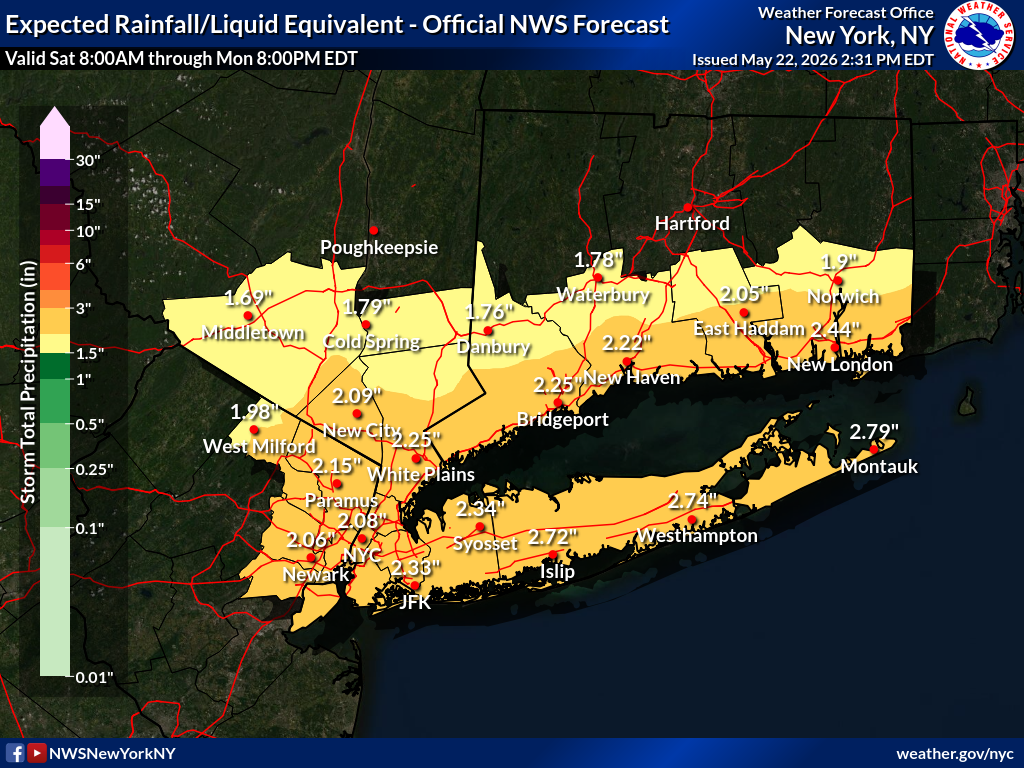
Clouds will increase tonight. Rain will develop tomorrow and continue into Sunday. A general 0.50"-1.50" rainfall is likely. Some locally higher amounts are possible. The temperature will likely remain in the 50s all day on Saturday and struggle to reach the lower 60s on Sunday. The mercury will likely return to the lower 70s on Monday. The ENSO Region 1+2 anomaly was +1.8°C and the Region 3.4 anomaly was +0.9°C for the week centered around May 13. For the past six weeks, the ENSO Region 1+2 anomaly has averaged +1.63°C and the ENSO Region 3.4 anomaly has averaged +0.70°C. El Niño conditions are now in place. The ongoing El Niño will continue to strengthen through the summer. The SOI was -19.74 today. The preliminary Arctic Oscillation (AO) was +0.868 today. Based on sensitivity analysis applied to the latest guidance, there is an implied near 66% probability that New York City will have a warmer than normal May (1991-2020 normal). May will likely finish with a mean temperature near 63.8° (0.6° above normal). Supplemental Information: The projected mean would be 1.3° above the 1981-2010 normal monthly value.
-
lol huh? That’s Stein depicted
-
Sending you all some rain from the Deep South/Southwest!
-
Are we losing Sunday ?!?
-
1.83 so far id love to hit 2" today
-
0.48” last night and today 1.48” total so far
-
True - many merchants in the shore towns will see less $$$ than expected but it will help the drought from getting any worse in the short term BUT we need soakers like this on a regular basis for a month or so to really lessen drought conditions - not lilkely with June traditionally not one of our wettest months and a stretch of sunny warm/hot long summer days more likely than not.
-
I checked the radar and saw them doing the split around you
-
Looks like we have hit the jackpot today. I have picked up a total of 1.74" so far. 1.19" from the first storm and .55" from the 2nd.
-

2026-2027 Strong/Super El Nino
roardog replied to Stormchaserchuck1's topic in Weather Forecasting and Discussion
Do you think we will flip to a +PDO this year? -

2026-2027 Strong/Super El Nino
snowman19 replied to Stormchaserchuck1's topic in Weather Forecasting and Discussion
IMO this Nino goes nuclear after this upcoming major WWB/ERW and subsequent (new) DWKW. It think that entire WPAC/Indo warm pool gets sloshed east by the end of this event @roardog Yes on the +PDO -
In other news, I've been seeing short and medium term forecasts that indicate that the weather pattern over the Southeastern US is changing and there is a persistent moisture flow setting up (which will be very beneficial as they've been in a very severe drought that's had a major impact on agriculture etc). I don't understand the meteorology behind all of that, but if we are on the fringes we might benefit by way of more consistent precipitation going forward (?)
-
For the record it does seem like we keep a wet pattern about here through Wednesday.
-
Sun is back out. I have a BBQ planned Monday. We will get rain all day Monday. You're welcome
-
Yep, slid around on either side of us. We got some sprinkles, just barely enough to make the deck wet.
- Today
-

2026-2027 Strong/Super El Nino
LakePaste25 replied to Stormchaserchuck1's topic in Weather Forecasting and Discussion
Plenty of gas in the tank out in the west pac and Nino 4 regions to go higher too.
-
Over 1.5” since Wednesday evening
-
maybe the wet nino pattern is finally arriving
-
yes the rain should be mostly over by Monday but if you are implying this will end the drought - think again Upton only going for less than 3 inches overall more south than north AFD from KOKX
-
wowzers
.thumb.png.298cd0d4143ed144b03788296842baa6.png)
-
Another round came through. Same old story. Storms broke up a few miles away, and reformed miles after me. I'm sure at some point the next week, we should actually get something.


.thumb.gif.f92b16c631a1d15d405ed77b33f0710d.gif)
.png.eeaa849b768aaa97c6287b051f497520.png)