All Activity
- Past hour
-
We are in one of our patented streaks where it just cannot rain.
-
Not sure, but I would like to apply for the position.
-

Central & Eastern Pacific Thread
BarryStantonGBP replied to Windspeed's topic in Tropical Headquarters
LMFAOOOOO GOOGLE AI MENTIONED Tropical Depression Ten-E Discussion Number 1 NWS National Hurricane Center Miami FL EP102025 200 PM MST Sun Aug 24 2025 Data from both the ASCAT-B and ASCAT-C scatterometers indicate that the broad area of low pressure located well offshore of the southwestern coast of Mexico now has a well-defined circulation. The deep convection has been forming a rudimentary banding structure over the western semicircle of the circulation. Thus, the system is being designated as Tropical Depression Ten-E at this time. The scatterometer observations indicate that the system is just below tropical storm strength, and the intensity estimate is in good agreement with a Dvorak estimate from TAFB. The initial motion estimate is west-northwestward, or 290/12 kt. A mid-level ridge is expected to remain to the northeast of the tropical cyclone during the next few days. This steering pattern should cause a west-northwestward to northwestward track for most of the forecast period. In 4-5 days, the weakening cyclone is expected turn more westward in the low-level flow. The official track forecast lies between the NOAA corrected consensus, HCCA, model and the Google Deep Mind, GDMI, predictions. The cyclone is currently over warm waters within moderate northeasterly vertical wind shear. Although the shear is predicted to lessen over the next couple of days, gradually cooling ocean waters should partially offset the more conducive wind environment. Therefore, only modest strengthening is forecast, and the NHC prediction is roughly in the middle of the model guidance. Around the end of the forecast period, significantly lower SSTs are likely to reduce the system to a remnant low. FORECAST POSITIONS AND MAX WINDS INIT 24/2100Z 16.0N 109.7W 30 KT 35 MPH 12H 25/0600Z 16.7N 111.4W 35 KT 40 MPH 24H 25/1800Z 17.7N 113.5W 40 KT 45 MPH 36H 26/0600Z 18.7N 115.5W 45 KT 50 MPH 48H 26/1800Z 19.7N 117.3W 45 KT 50 MPH 60H 27/0600Z 21.0N 118.8W 45 KT 50 MPH 72H 27/1800Z 22.4N 120.0W 40 KT 45 MPH 96H 28/1800Z 24.5N 121.5W 30 KT 35 MPH 120H 29/1800Z 25.0N 122.5W 25 KT 30 MPH...POST-TROP/REMNT LOW $$ Forecaster Pasch -

Occasional Thoughts on Climate Change
donsutherland1 replied to donsutherland1's topic in Climate Change
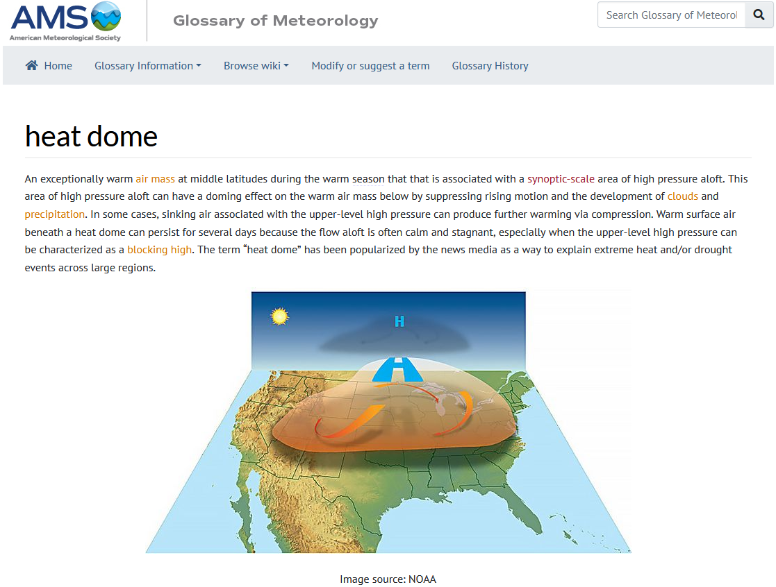
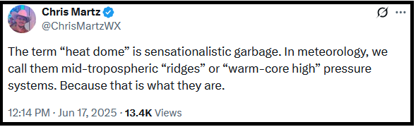
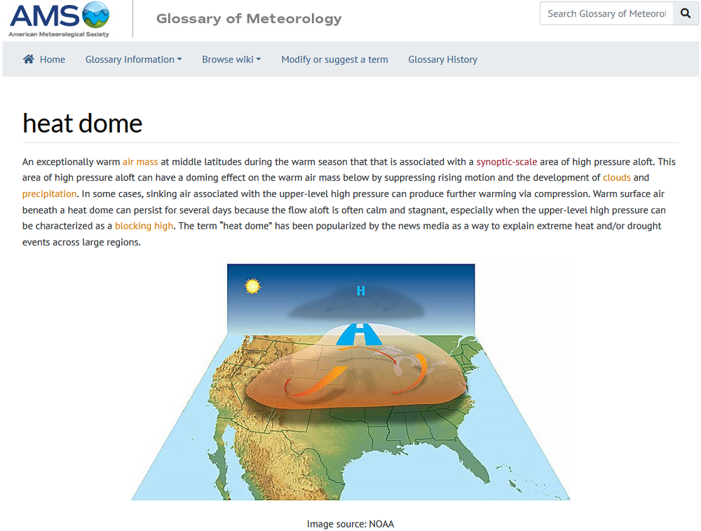
The Reality: "Heat Dome" is a standard term in the AMS Glossary of Meteorology Now, on a more serious note: I suspect that X-post by X-post, one sees the reason he is working out-of-field as a policy analyst for an interest group (not a scientific organization), neither as an operational nor research meteorologist. To work in a profession like meteorology, one can't impose one's personal opinions or preferences on what is a scientific field. One has to apply the evidence, theories, and principles of that field (even if one personally disagrees), until or unless one comes up with a credible, evidence-based alternative that is better than the understanding it would replace. In operational meteorology, it is imperative that meteorologists today be able to explain the climate link for extreme events e.g., how climate change has made extreme precipitation events more frequent and/or more intense, especially on TV or radio. Trashing attribution science to avoid recognizing climate-weather links one personally rejects or treating the evolution of climate as nothing more than an abstract statistic, is disqualifying. In the research area, one must be objective in all areas ranging from framing research questions to interpreting the evidence. Finally, his criticism directed against meteorologists, along with high-profile climate scientists, on X has likely shut doors to professional opportunity at the NWS and large private firms such as AccuWeather. Meteorologists, like most other professionals, work closely together. Someone who would undermine team chemistry would be a problem for the entire team's performance. His social media history can easily be reviewed through Glassdoor, among other social media-scraping applications. Employers won't seriously consider hiring someone who might not fit within an organization's culture, chemistry, and structures. Employers understand the importance of culture, chemistry, and structure to high performance, and the importance of high performance to their organizations' success. They won't knowingly compromise these attributes in their hiring process. Technology has made due diligence far more robust and cost-effective than it once was. Organizations won't gamble with the sources of their success, as they would have too much to lose.
-
DP up to 71.
-
 84 here today, lots of clouds
 -
It looks like the uneventful HRRR had the best handle on the activity today. It looks like a nice evening on tap.
-
INVEST 99L - 30/30 AND BUSSIN
BarryStantonGBP replied to BarryStantonGBP's topic in Tropical Headquarters
LMFAOOOOOO Active Systems: The National Hurricane Center is issuing advisories on Tropical Storm Fernand, located over the central subtropical Atlantic. 1. East of the Windward Islands (AL99): Data from the Air Force reconnaissance aircraft indicate that the system located near the Windward Islands does not have a closed low-level circulation. However, the system is still producing a large area of showers and thunderstorms and winds to near gale force, and these conditions are expected to affect the Windward and Leeward Islands tonight and Monday. The system is expected to reach the central Caribbean Sea on Tuesday, where conditions are forecast to become less favorable for additional development. * Formation chance through 48 hours...low...30 percent. * Formation chance through 7 days...low...30 percent. -

INVEST 99L - 30/30 AND BUSSIN
WxWatcher007 replied to BarryStantonGBP's topic in Tropical Headquarters
Recon shows it as a sharp wave at best. No reason to bet on this one if/until it survives the graveyard. -
That is unfortunate, people who intentionally spread blatant misinformation like this should have their accounts flagged for intentional misinformation, people like this are a major contributor to the downfall of society. It has gotten a lot worse since the pandemic as people spend more time online and less time in the real world.
- Today
-
How does one perform a field sorority test, if I may ask?
-
 Made it to 86 and clouds stayed north and it was partly cloudy here.
 -

Occasional Thoughts on Climate Change
Typhoon Tip replied to donsutherland1's topic in Climate Change
https://phys.org/news/2025-08-sea-ice-ocean-currents-antarctica.html -
Central & Eastern Pacific Thread
BarryStantonGBP replied to Windspeed's topic in Tropical Headquarters
EP, 10, 2025082418, , BEST, 0, 157N, 1093W, 30, 1006, LO, 34, NEQ, 0, 0, 0, 0, 1009, 150, 60, 0, 0, E, 0, , 0, 0, TEN, M, 0, , 0, 0, 0, 0, genesis-num, 019, TRANSITIONED, epB22025 to ep102025, -
More like past the first round lol
-
In that case I better check the ring cam
-
Yea it's like waiting for that one million dollar Publishers Clearing House check to arrive at your door.
-
More accurate would have been, “Welcome to Toronto where our hockey team no matter how talented, can never make it past the second round of playoffs”
-
I hope they did a field sorority and drug test on the pilot

-
2025-2026 ENSO
donsutherland1 replied to 40/70 Benchmark's topic in Weather Forecasting and Discussion
I suspect that he intended it. After all, he corrected himself elsewhere in the thread he started, but ignored the multiple corrections concerning the solar state. If he corrected himself on one issue, there's no plausible reason he would not do so for another error, unless he intended his statement to be what it was. -
Current radar looks pretty unimpressive right now. I wonder when, or if, anything good starts to fire up.
-
Still good size waves at the Maine beaches, people are allowed to go in ankle deep, everyone i saw were waist deep.
-

-
Excellent day to hit the mackerel at Goat Island in PSM. A little breezy but comfortable.
-
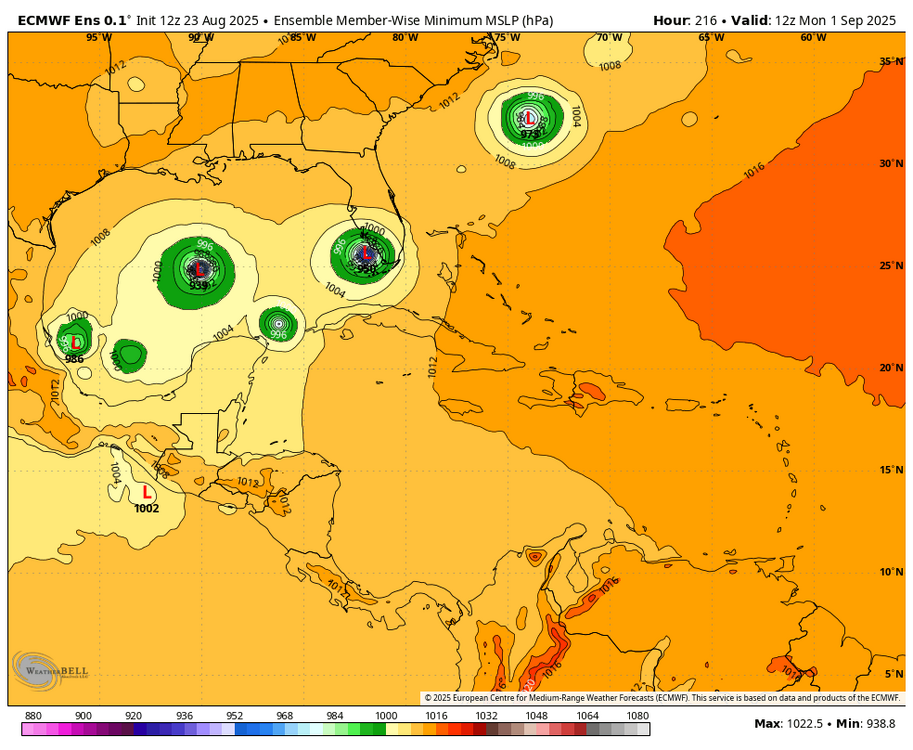
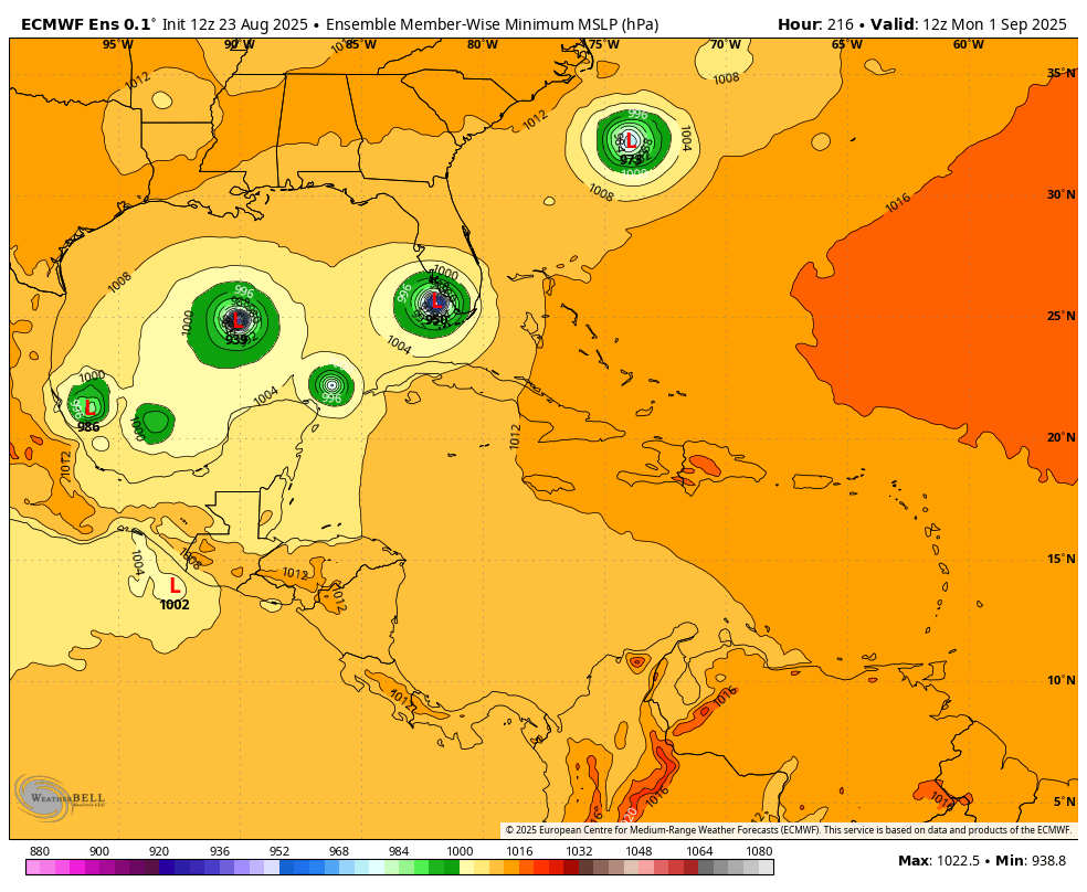
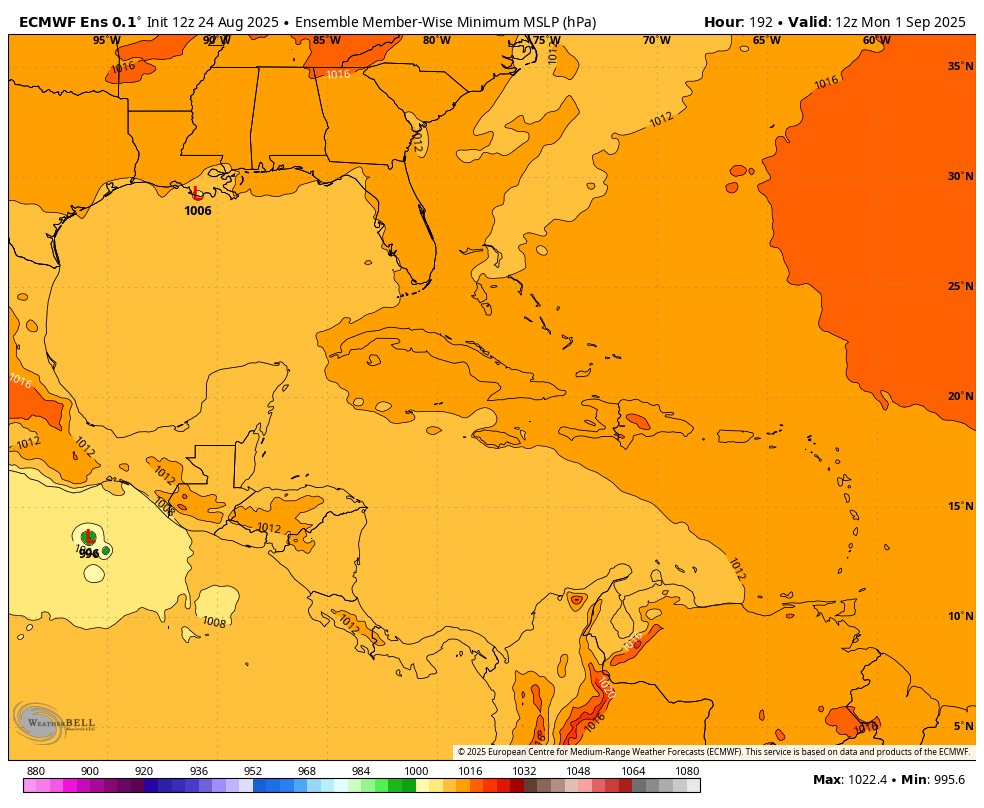
The Euro ensemble, which for Invest 99L had gotten significantly more active 24 hours ago and then on the 0Z significantly less active than yesterday’s 12Z run, was very quiet on today’s 12Z with virtually nothing. Check out the difference between 12Z yesterday and 12Z today: 12Z yesterday at 216: somewhat active 12Z today at 192: nothing!