All Activity
- Past hour
-
 Southern NJ where you live has literally nothing to do with New England or weather correlation. Even NYC Climo is better then yours man
 -

December 2025 Short/Medium Range Forecast Thread
John1122 replied to John1122's topic in Tennessee Valley
Been reading on the MJO today as I wait for the Tennessee game to start. The MJO phase only affects North American temperatures apparently in relation to the proposed in the paper, MVP (multivariate PNA). For instance, in the article I am reading, phase 5 is only warm if the MVP is also negative. This is from that paper. "The MVP is the first combined EOF of 20–100-day OLR, 850-hPa streamfunction, and 200-hPa streamfunction over the North Pacific and North America. The North American temperature patterns that follow each phase of the MJO change with the sign of the MVP. For example, real-time multivariate MJO (RMM) phase 5 usually leads to warm anomalies over eastern North America. This relationship was only found when the MVP was negative, and it was not associated with El Niño or La Niña. RMM phase 8, on the other hand, usually leads to cold anomalies. Those anomalies only occur if the MVP is positive, which happens somewhat more frequently during La Niña years. Composite analyses based on combinations of the MJO and the MVP show that variability in the Pacific jet and its associated wave breaking play a key role in determining whether and how the MJO affects North American temperatures." The article can be found here. https://journals.ametsoc.org/configurable/content/journals$002fmwre$002f141$002f11$002fmwr-d-13-00118.1.xml?t:ac=journals%24002fmwre%24002f141%24002f11%24002fmwr-d-13-00118.1.xml -

December 2025 Short/Medium Range Forecast Thread
Carvers Gap replied to John1122's topic in Tennessee Valley
Haha. The 18z GFS has freaking hurricane in the Gulf on December 6th. Not sure I have seen that before! -
For regional weather forecasting, beyond 10 days has low predictive utility, even on the ensemble means. And we don't even have anything favorable within that time period yet. Right now we are looking at mostly a storm track to our west with cold snaps on the wake of storms. That's within seasonal norms. If we get a cold and snowy look inside day 10 on multiple ensembles, it's a plausible outcome. Inside day 7 and it's worth getting a little excited about. But IMO, anything outside of that range is fantasy range territory.
-

November 2025 general discussions and probable topic derailings ...
eduggs replied to Typhoon Tip's topic in New England
Don't count your chickens guys/gals. It's risky to lock in a cold Canada based on a 15 day model forecast. Plenty of individual members plus operational runs show only transient cold up there. The ensemble mean blends it to look like wall to wall continuous cold, which it likely won't be. Out to day 10 does not look favorable for wintry weather at the moment on the ensembles. Beyond that gets increasingly unreliable in terms of predictive value. Most of us are passionately hoping for cold and snowy. But we've seen it too often over the past few years where many here bake in unrealistic expectations based on fantasy-range model charts. -
Need the cold to get the snow.
-

Pittsburgh PA Fall 2025 Thread
CoraopolisWx replied to TheClimateChanger's topic in Upstate New York/Pennsylvania
12/9/92 might be my favorite storm, mostly for the nostalgia. -
 SWFEs are such an easy forecast. 5-7” thump followed by slot and drizzle. Could stat padders too.
 -

November 2025 general discussions and probable topic derailings ...
Typhoon Tip replied to Typhoon Tip's topic in New England
Suppression, kind of is negative interference… But yeah, either way we look at it -
(002).thumb.png.6e3d9d46bca5fe41aab7a74871dd8af8.png)
Central PA Fall Discussions and Obs
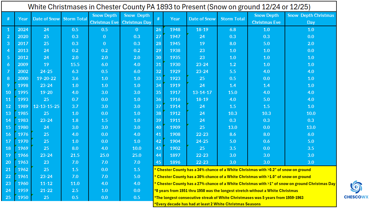
ChescoWx replied to ChescoWx's topic in Upstate New York/Pennsylvania
Some additional details on White Christmas history and probabilities across Chester and SE Berks Counties including the storm dates and snow amounts on the ground both Christmas Eve and Christmas Day.
-
E PA/NJ/DE Autumn 2025 Obs/Discussion
ChescoWx replied to PhiEaglesfan712's topic in Philadelphia Region
Some additional details on White Christmas history and probabilities across Chester and SE Berks Counties including the storm dates and snow amounts on the ground both Christmas Eve and Christmas Day.
-

November 2025 general discussions and probable topic derailings ...
Torch Tiger replied to Typhoon Tip's topic in New England
reasoning there? supression, interference, both? -
November 2025 general discussions and probable topic derailings ...
Torch Tiger replied to Typhoon Tip's topic in New England
07-08 was good but not spectacular in wilmington, ma with around 70" or so iirc. maybe a touch higher like 75"? Best event was probably 12/16 in terms of impacts also iirc -

November 2025 general discussions and probable topic derailings ...
rimetree replied to Typhoon Tip's topic in New England
Gladly take an '07 - '08 winter. Nearest coop was 93". -
November 2025 general discussions and probable topic derailings ...
Torch Tiger replied to Typhoon Tip's topic in New England
maybe for the mid-atlantic, which would kinda be on-par, but I'm far more optimistic around here. -
November 2025 general discussions and probable topic derailings ...
Typhoon Tip replied to Typhoon Tip's topic in New England
In fact it would harm matters -

November 2025 general discussions and probable topic derailings ...
qg_omega replied to Typhoon Tip's topic in New England
2-3 weeks then winter is over -
Many times my first acc. snow has been around Dec. 5.
-
Rob you and S19 will never be a D D. Our ocean hugging, UHI blessed five borough coastal plain location ensures Debbie will always be welcome in December. Stay well and hopeful, as always …..

-
Yep, its about the cold & pattern of the period. Obviously I posted a 7 day mean of 2013 & only one specific frame of today's 12z GFS. The system on the GFS is very similar to the system in early DEC 2013. Not making a point about the entire winter.
-
A generally milder than normal pattern will likely continue through next Wednesday. However, exceptional warmth appears unlikely. The closing days of November will likely turn colder. There is potential for New York City's Central Park to experience its first freeze of 2025. The 1991-2020 normal first data is November 21. The 1961-1990 baseline was November 11. Last winter's first freeze occurred on November 30. The opening days of December will turn milder. However, colder conditions could begin to develop during the second half of that week and continue through the second week of December. Severe cold appears unlikely through at least the first 10 days of December. Afterward, the pattern evolution will depend, in part, on how the imminent stratospheric warming event propagates. Meanwhile, today will be Central Park's 1,393rd consecutive day without daily snowfall of 4" or more. The record of 1,394 days was set during February 22, 1929 through December 16, 1932. That stretch ended with 6.7" daily snowfall on December 17, 1932. The ENSO Region 1+2 anomaly was -0.7°C and the Region 3.4 anomaly was -0.7°C for the week centered around November 12. For the past six weeks, the ENSO Region 1+2 anomaly has averaged -0.16°C and the ENSO Region 3.4 anomaly has averaged -0.65°C. La Niña conditions will likely continue through at least mid-winter. The SOI was +31.56 today. The preliminary Arctic Oscillation (AO) was +1.436 today. Based on sensitivity analysis applied to the latest guidance, there is an implied 86% probability that New York City will have a cooler than normal November (1991-2020 normal). November will likely finish with a mean temperature near 46.6° (1.4° below normal). Supplemental Information: The projected mean would be 1.1° below the 1981-2010 normal monthly value.
-
No snow cover below 4500' around here, just a cold drizzly rain, low overcast becoming fog above my elevation (which is 3500'). A thin snow cover in the alpine possibly 3-5" tops.
-
Very short window this year for wintry wx
-
As long as they involve a lot of ice . South of 90 does not do well with snow in those
-

November 2025 general discussions and probable topic derailings ...
CoastalWx replied to Typhoon Tip's topic in New England
I think we’d all get some popcorn ready and watch Ray light up this forum.