
All Activity
- Past hour
-
 https://northrxcanada.shop/# best online canadian pharmacy
 -
Yup. Wife and I took the dogs for a walk like 40 minutes ago and we both were saying how nice it felt out.
-
Was gunna say. Been overcast since around 330pm. Nice breeze too.
-
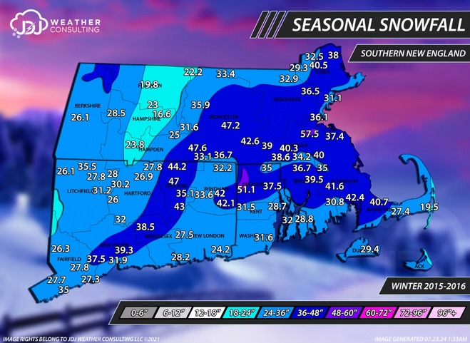
2015-16 wasn’t that bad for snow in southeastern areas…actually kind of impressive considering a near complete shutout in December that season
-
Been overcast here in NJ for a bit now
-

Septorcher 2026 Discussion - Endless Summer
Baroclinic Zone replied to Damage In Tolland's topic in New England
Gotta go back to early June when temps dropped this low. Gorgeous day. 10/10. Autumn is here and it’s glorious. -

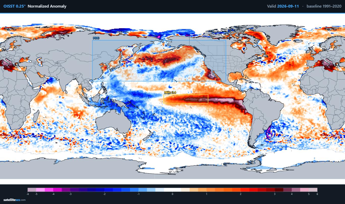
2026-2027 Record-breaking El Nino
Ephesians2 replied to Stormchaserchuck1's topic in Weather Forecasting and Discussion
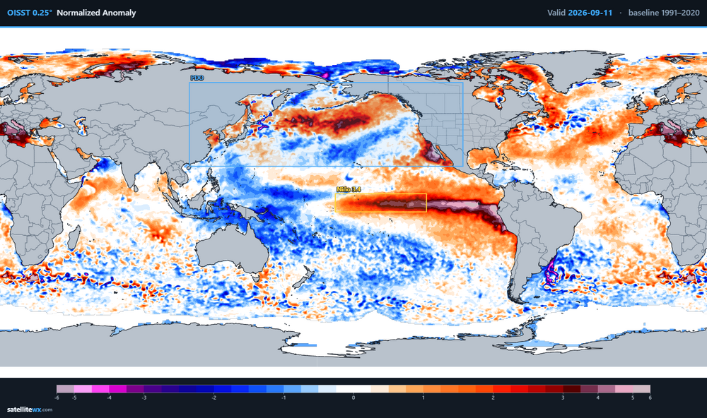
is that ridge south of the aleutians a nino pattern? -
already pretty neutral looking, we'll almost certainly have a positve PDO by November/December. We also got a pretty good pacific pattern the last two winters even with Nina/-PDO
-
It would really be something if we were completely shut out from this event.
-
buy medicine without prescription: buy medication from india : buy medicine from india to usa
-
I also like the look of the northward moving stuff over southern VA. Hope it holds together for later. It would be real nice if Sept cooperates so that the last two months of summer were above average rainfall
-

2026-2027 Record-breaking El Nino
BuffaloWeather replied to Stormchaserchuck1's topic in Weather Forecasting and Discussion
lol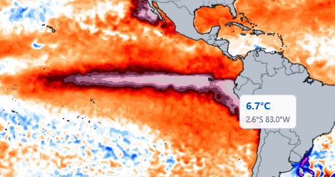
-

Central PA Summer 2026 Discussion/Obs Thread
mahantango#1 replied to Voyager's topic in Upstate New York/Pennsylvania
I wonder if the Susquehanna Valley will get any good storms tonight? -
Central PA Summer 2026 Discussion/Obs Thread
mahantango#1 replied to Voyager's topic in Upstate New York/Pennsylvania
No problem, I don't like to step on other people's toes either. But it happens. -
September 10 is average date by which the Triad reaches 90 degrees. Next week, has two or three chances to reach 90 before it looks like the end of this year’s hot weather.
- Today
-
WPC keeps the slight risk of heavy rain along 95. Meanwhile the 19z hrrr gives me 0.00”. Not even a T.
-
0.28" Feels like mid-July, not mid September. High of 86 at 1pm, low of 73 at 3:53am.
-
First rain in over a week. It’s been raining since 1:00 at my house, adding up to 0.95”. Thank you God.
-
Yea, it means no arctic source, but the airmass can work in January-Feb.
-

Septorcher 2026 Discussion - Endless Summer
Damage In Tolland replied to Damage In Tolland's topic in New England
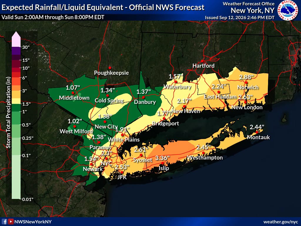
I still think S coast to SW CT is were the heavy stuff is . Someone gonna get the the Roman Stein relatively speaking -
NWS UPTON, 5 to 7 inch possibility IMPACTS...Excessive runoff may result in flooding of rivers, creeks, streams, and other low-lying and flood-prone locations. ADDITIONAL DETAILS... - Showers with heavy downpours and a few thunderstorms early Sunday morning into midday Sunday may lead to flooding. Average rainfall amounts are forecast to range from 1.5 to 3 inches with locally higher amounts of 5 to 7 inches possible. Peak hourly rates could reach 2 to 2.5 inches. - http://www.weather.gov/safety/flood PRECAUTIONARY/PREPAREDNESS ACTIONS... You should monitor later forecasts and be alert for possible Flood Warnings. Those living in areas prone to flooding should be prepared to take action should flooding develop.
-

Septorcher 2026 Discussion - Endless Summer
CoastalWx replied to Damage In Tolland's topic in New England
However, you can see stein hiding behind the trees on some of the 18z runs. Just hiding and then when nobody is looking, going from one tree to the next. -
I’m not sure why anybody engages with the same poster who has posted “warm and rainy” a dozen times in this thread.
-
I'll take it and am also drooling over the map @40/70 Benchmark published a few days ago. Both of my guest rooms are put together so plan on coming out for the paste bomb














.thumb.JPG.418e8a9a2902ae687ec35ff4bc0e038e.JPG)