All Activity
- Past hour
-

Fall 2025 Medium/Long Range Discussion
Powerball replied to Chicago Storm's topic in Lakes/Ohio Valley
Clippers have to be an endangered species at this point, but it's been that way for a while. I remember them being quite common in the 90s through mid-2000s. -
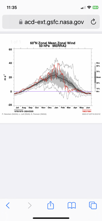
Thanks, Don. One thing helping 2025 vs 1983 is that 1983 didn’t have a weak SPV as it didn’t get <15 m/s through Nov and Dec:
-
28° Moderate Frost
-

Central PA Fall Discussions and Obs
Jns2183 replied to ChescoWx's topic in Upstate New York/Pennsylvania
Homemade egg nog and black Friday snow storm are a 2:1 special Sent from my SM-G970U1 using Tapatalk -

November 2025 general discussions and probable topic derailings ...
weatherwiz replied to Typhoon Tip's topic in New England
There was alot of ice in my freezer this morning too, more than usual. that's because I turned on the ice maker -

December 2025 Short/Medium Range Forecast Thread
Carvers Gap replied to John1122's topic in Tennessee Valley
And you know, I really didn't look closely at the 0z Euro...but it was close to a decent storm on the 29th. It had almost a foot and a half in the Apps. After the Euro nailed this last system, it might carry a bit more weight if it shows the same thing again at 12z. -
I think NYC will eventually see another 4” day. Not sure when though. But the more impressive streak for NYC had been no March 10” daily snows since 1993. It’s possible that the climate has warmed too much for that record to be reached again. 1993-03-13 40 28 34.0 -7.8 31 0 2.37 10.2
-

Central PA Fall Discussions and Obs
canderson replied to ChescoWx's topic in Upstate New York/Pennsylvania
Where do I sign up for the Black Friday snowstorm? -
 Yep. 1st skim ice on the pond i drive by in my town each day. 20F for my low
 -
December 2025 Short/Medium Range Forecast Thread
Carvers Gap replied to John1122's topic in Tennessee Valley
In watching the 12z GFS and ICON rollin in for next Thursday into Friday, I can't help but think there is room for snow in that setup. The ICON has another, albeit weaker, NW flow event modeled. The GFS is close to something for west TN. That front is much strong at 12z than it was at 6z. -
November 2025 general discussions and probable topic derailings ...
weatherwiz replied to Typhoon Tip's topic in New England
Who uses an umbrella when its windy? -

November 2025 general discussions and probable topic derailings ...
Kitz Craver replied to Typhoon Tip's topic in New England
Gonna make Ray’s holiday thaw that much more painful -
 I mean ultimately though, nobody cares about skim ice on a local pond. If it doesn’t snow, nobody is going to care what else is going on. Lets actually get some measurable snow before we start talking about how great things will be. Weve done a lot “things look promising” the last half decade and have come away usually with nothing to show. Need results
 -
Yes, and even last year, 4"+ storm before Xmas for some nearby the city and same on Jan 19th.
-
But yes, the coldest we've had in northeast Queens thus far is 33 degrees last week, around 6-7 am one of those days, I believe it was Veterans Day. Used to regularly have the first freeze by mid november, but most of the 2020s, it's been pushed back to December. First frost used to be late October, now it's been pushed back a few weeks as well.
-
December 2025 Short/Medium Range Forecast Thread
Carvers Gap replied to John1122's topic in Tennessee Valley
For the record, we had lightning and thunder two nights ago(I think) as it pass along the VA/TN border. -
Looks like the day before Thanksgiving will be quite warm in NYC, around 60 degrees. Thanksgiving should be a little cooler, and then it seems like we go into a prolonged stretch of colder than normal temps from Black Friday through at least first 10 days of december (so around 2 weeks of below normal temps for at least the foreseeable future). Hopefully next Wednesday is last warm day for a while.
-

November 2025 general discussions and probable topic derailings ...
IrishRob17 replied to Typhoon Tip's topic in New England
Hopefully its not a field day for the heat, a thousand people in the street. -
December 2025 Short/Medium Range Forecast Thread
Carvers Gap replied to John1122's topic in Tennessee Valley
I remember that winter. We got a front end thump of 4-5 inches...and then it rained and washed it all away in the same storm. -

November 2025 general discussions and probable topic derailings ...
WinterWolf replied to Typhoon Tip's topic in New England
We’ve been trying to tell you this… -
Brutally cold and snowy winter on the way. I know Don was mentioning about the cold pool is much smaller than in 1968 but this is not arctic air coming it is Siberian cold and with the pdo rising that would increase snowstorm chances.
-
December 2025 Short/Medium Range Forecast Thread
Carvers Gap replied to John1122's topic in Tennessee Valley
These were yesterday's d8-14 analogs. Half of those analogs are from exemplar winter time frames. I am not saying we get to those levels, but CPC thinks the d8-14 pattern is similar at least. Now, there has been some moderation(quite a bit actually) in modeling overnight. So, let's see what CPC picks today. 20071127 20001207 19761202 (sets the bar for winter) 20081204 19581206 19781123 (sets the bar for winter) 19631214 (noted for several southern snow storms...very interesting analog) 19851212 (see John's notes above...) 19911126 19891209 (crazy cold December) -

November 2025 general discussions and probable topic derailings ...
dryslot replied to Typhoon Tip's topic in New England
On my way back from Wales this morning, Sabattus Lake was skimmed over, These last several days of temps in the 30's and teens at night has jump started ice buildup. -
Hopefully it materializes. Probably not a given though.
-
Oh I thought you were talking about the euro weeklies. I don't expect much from the nao until the SSW + scand ridging take effect and (hopefully) retrogrades over greenland


