All Activity
- Past hour
-
Point and click has 76 for the high here today. Doubting MBY gets over 70 unless we see a more westerly wind. Currently at 66 and S wind but places west/north are over 70.
-
70.0° The air finally feels alive
-
At the end of April it was looking like May was going to finally usher in a wet pattern, now it seems to have completely collapsed. What went wrong?
-
Winds may end up underperforming today too
-
Believe me, I would love to live on the coast of Maine, but there’s just not enough warmth.
-
At least tomorrow should provide some widespread rains...nothing eye opening in terms of totals but a nice little drink. PWATS are rather high though so could be some room to get towards the higher end guidance tomorrow
-
He has had one too many craft beers.
-
Wait wut? Weeklies nailed the last 25 days you were-7 over that period according to the Staffordville coop.
-

Mountain West Discussion
mayjawintastawm replied to mayjawintastawm's topic in Central/Western States
Been away for work the last 10 days... what a difference! This setup reminds me of the storm in 2022 where we got close to a foot of snow, with the difference in our neighborhood being that many trees that had leafed out are all shriveled this year because of 20 degree temps a couple weeks ago- so, ironically, are protected! 35 F and 0.20 inches of rain so far. -
12z NAM brought a lot of the snow back to the Palmer Divide, so maybe it just didn't have coffee at 6z. 34 degrees here, several degrees below what was forecast for this time of day.
-
Low here of 30 too with snow showers as well. Gonna be a chilly next few days. 26 days until met summer. edit: some of these snow showers are quite robust too.
-

Central PA Spring 2026 Discussion/Obs Thread
Jns2183 replied to Voyager's topic in Upstate New York/Pennsylvania
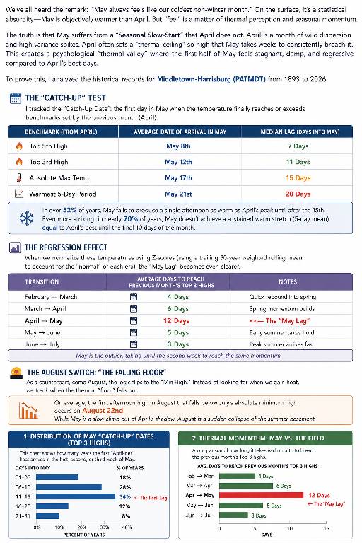
This comment was a gold mine to explore We’ve all heard the remark: “May always feels like our coldest non-winter month.” On the surface, that sounds statistically absurd. May is objectively warmer than April by the monthly averages. But “feel” is not just a raw average. It is thermal perception, seasonal expectation, and momentum. April is chaotic: a month of high variance, sharp warm spikes, and sudden spring previews. May, by contrast, often starts by lagging behind the psychological benchmark April just created. That is the core of the Seasonal Slow-Start. April frequently sets a thermal ceiling so high that May takes days, and sometimes weeks, to consistently breach it. Using historical records for Middletown-Harrisburg (PATMDT), 1893–2026, I tracked the first date in May when temperatures reached or exceeded several April benchmarks. The result is the “Catch-Up Date.” In over 52% of years, May does not produce a single afternoon as warm as April’s peak until after May 15. Even more striking, in nearly 70% of years, May does not produce a sustained five-day warm stretch equal to April’s best until the final ten days of the month. This is why early May can feel so weirdly disappointing. The month is warmer on paper, but it often opens beneath the emotional standard April already set. When the data is normalized using era-adjusted Z-scores based on a trailing 30-year weighted rolling mean, the effect becomes clearer: after a very warm April, early May can register as a real regression. Compared with other spring and early-summer transitions, May is the outlier. March usually catches February’s top warmth quickly, June catches May quickly, and July catches June almost immediately. But May takes until the second week, on average, to catch April’s top-three warmth. That delay is the statistical footprint of the “cold May” feeling. Sent from my SM-S731U using Tapatalk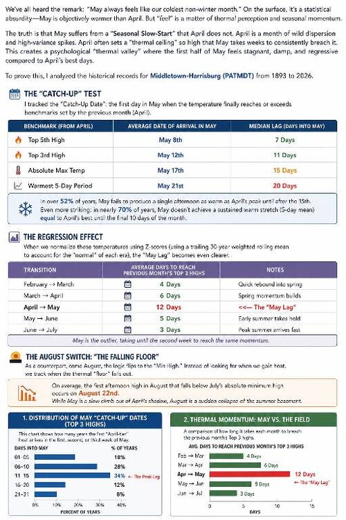
-

2026-2027 Strong/Super El Nino
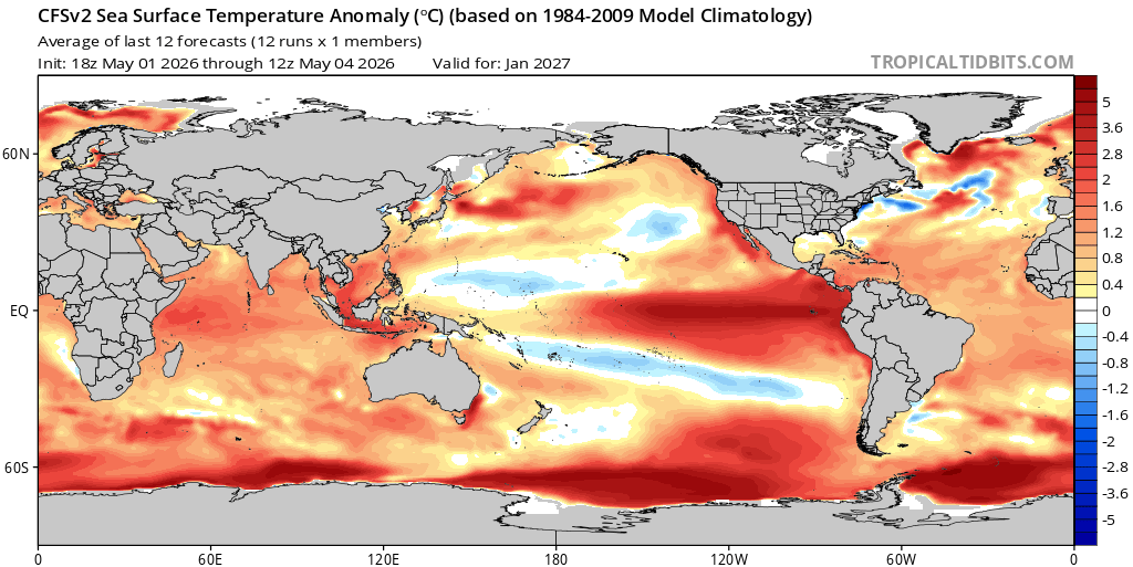
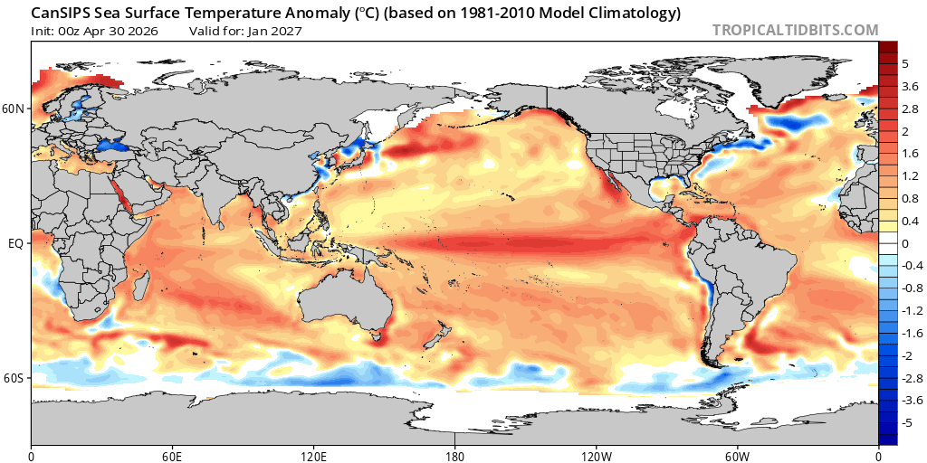
GaWx replied to Stormchaserchuck1's topic in Weather Forecasting and Discussion
Also, note that like the CFS that it has the Nino east based. Taking a few tenths off of this Euro prog due to its warm bias and then cooling it ~0.5 to roughly estimate RONI likely yields something pretty similar to the +2.5 C peak RONI (+2.7C peak month) of the most recent CFS runs, which would be near a record warm RONI (back to 1950) and would be a 1982-3 redux. -
72 / 51 gorgeous dy. Warmest of the next week with Mothers coming in a close second. Clouds / cooler and rain showers 0.20 - 0.30 area wide Wed. with nice cooelr weather Thu - Fri and clouds and rain showers Saturday similar to wed. Mothers day back into the 70s/warm. Overall near / below normal 5/11 - 5/15 with moderation to warmer as ridging builds east boyond mid month. Next heat maybe in the 5/17 - 5.24 range?
-
It’s 65 outside. Maybe see a doctor
-
breezy but yesterday was far windier. we'll see if that changes 60° so far, hope to touch the mid 60s
-
70 so far the wind's a no show here. Perhaps we have a thinly stable layer just yet...
-
TORCH! up to 70 here
-
May 5 1965: At least 7 tornadoes hit southern Minnesota. This outbreak is a preview of what would happen the next day… For Tuesday, May 5, 2026 1917 - The same storm which a day earlier produced eight inches of snow in the Texas panhandle, produced a foot of snow at Denver CO, their heaviest snow of record for the month of May. (David Ludlum) 1930 - The temperature at College Park, VA, soared from 43 degrees to 93 degrees to begin an exceptional heat wave. (Sandra and TI Richard Sanders - 1987) 1987 - Unseasonably hot weather prevailed in the western U.S. A dozen cities in California reported record high temperatures for the date. Afternoon highs of 93 degrees at San Francisco, 98 degrees at San Jose, 100 degrees at Sacramento, and 101 degrees at Redding, were the warmest of record for so early in the season. The high of 94 degrees at Medford OR was also the warmest of record for so early in the season. (The National Weather Summary) 1987 - Parts of the western U.S. were in the midst of a blistering May heat wave. The reading of 100 degrees in Downtown Sacramento CA was their earliest of record. Sacramento CA established daily record highs on nine of eleven days between the 4th and the 14th. (The Weather Channel) 1988 - A stubborn low pressure system continued to drench the eastern U.S. with rain. Thunderstorms again produced large hail in North Carolina. (The National Weather Summary) 1989 - Thunderstorms swept across Georgia and the Carolinas during the late afternoon and evening hours spawning seventeen tornadoes. A tornado at Toccoa GA injured 15 persons, and a tornado at Chesnee SC killed two persons and injured 35 others. Five tornadoes in North Carolina accounted for five deaths, 88 injuries, and sixty million dollars damage. Thunderstorms also produced baseball size hail at Lake Murray SC, and wind gusts to 78 mph at Brooklyn MD. (The National Weather Summary) (Storm Data) 1990 - A strong Pacific cold front moving rapidly inland caused weather conditions at the east end of the Strait of Juan de Fuca in Washington State to quickly change from sunny and calm to westerly winds of 60 mph and ten-foot waves. Three recreational fishing boats capsized in heavy seas off Port Angeles resulting in five deaths. In California, temperatures soared above 90 degrees across much of the state. The high of 101 degrees in downtown Los Angeles was eight degrees hotter than their previous record for the date. (The National Weather Summary) (Storm Data)
-
2026-2027 Strong/Super El Nino
GaWx replied to Stormchaserchuck1's topic in Weather Forecasting and Discussion
Also, note that climo used for TT’s CFS is 1984-2009, which is cooler than 1991-2020. If these CFS happen to verify, they’d make much more sense vs history of strong El Niño with their coolest anomalies in the S US vs the coolest anomalies on Cansips being in the N US, which is extremely out of sync with strong Nino climo. Also, the CFS has had and continues to have a stronger and more E based Nino vs a not quite as strong C to W based Nino on the Cansips runs: CFS: E based Cansips: C to W based and not quite as strong

-
After May 20th I think
-

2026 Atlantic Hurricane Season
Stormchaserchuck1 replied to Stormchaserchuck1's topic in Tropical Headquarters
-
The weeklies and charts performed extremely poorly for this whole cold month period you had
-
It's basically just seasonal increases in baseline temps, which we take. But yeah I don't see a torch imminent either
-
another modeled wet couple days has turned into .10 to .30 of QPF