All Activity
- Past hour
-

2026-2027 El Nino
40/70 Benchmark replied to Stormchaserchuck1's topic in Weather Forecasting and Discussion
Maybe in terms of temps, but I doubt in terms of snowfall. 1982, 1997 and 2015 all had one great storm. -

Central PA Spring 2026 Discussion/Obs Thread
Mount Joy Snowman replied to Voyager's topic in Upstate New York/Pennsylvania
Low of 42. My trusty ‘ol push mower fired right up yesterday. Splendid weekend ahead before we turn hot for next week. Happy Friday, all. -

2026-2027 El Nino
bluewave replied to Stormchaserchuck1's topic in Weather Forecasting and Discussion
I have no idea what would happen to benchmark storm tracks following another rapid warming event so soon after 2023-2024. Around NYC metro we have been in an all or nothing snowfall regime since the mid 1990s. So every year with a benchmark KU like this past winter has gone to at or above the long term average snowfall. Very few 18-30” seasons anymore which were common from the 1960s to 1990s. Most years without a benchmark event like 22-23, 23-24, and 24-25 finished up with under 18” across multiple locations. Back in the 1840s to early 1870s a recently discovered excellent set of long term weather observations showed the average annual snowfall at Newark in the low 40s over a 30 year period. This gradually declined into the mid 20s by the early 1990s. We had a big bounce back decade during the 2010s which was built on a record number of benchmark KU snowstorms. From 2019 to 2025 the benchmark track was largely absent so we had numerous very low snowfall years. This winter started out with an outstanding clipper pattern in December which pretty much maxed out the potential of what the Northern Stream could do if everything went just right. Then the Northern Stream finally relaxed for around 30 days from late January until late February. So only one month of relaxation yielded the record KU event in late February. March reverted to the dominant Northern Stream pattern which had resulted in the lowest March snowfall over 7 consecutive seasons around NYC Metro from 2020-2026. So taking the very long view has given us a steady decline since the 1840s in seasonal snowfall around NYC Metro with bounce back periods from time to time. No matter how warm this El Niño gets next winter, I will never give up hope for bounce back seasons and potential benchmark events from time to time. The big question is what type of interval of reoccurrence will we be looking at? Warm winters like 2015-2016 and 2016-2017 were proof of concept that we could get great benchmark storms even in a warm season. So it will just come down to having the benchmark tracks pushing back from time to time against the strong Northern Stream tendency we had since 2019. -
(002).thumb.png.6e3d9d46bca5fe41aab7a74871dd8af8.png)
Central PA Spring 2026 Discussion/Obs Thread
ChescoWx replied to Voyager's topic in Upstate New York/Pennsylvania
Today will be our first above normal temperature day since Easter Sunday. We should see some sun later today with temperatures well into the 60's. We chill back to normal temperatures over the weekend with highs in the low 60's before a big warmup next week. The warmest day here in Chester County looks to be Wednesday with highs in the low to mid 80's (1st 90+ possible near the Philly heat island area) Temperatures start to cool a bit later next week. Sadly, no rain in the forecast at all!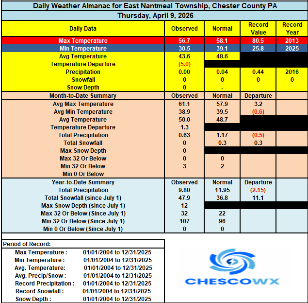

-
E PA/NJ/DE Spring 2026 Obs/Discussion
ChescoWx replied to PhiEaglesfan712's topic in Philadelphia Region
Today will be our first above normal temperature day since Easter Sunday. We should see some sun later today with temperatures well into the 60's. We chill back to normal temperatures over the weekend with highs in the low 60's before a big warmup next week. The warmest day here in Chester County looks to be Wednesday with highs in the low to mid 80's (1st 90+ possible near the Philly heat island area) Temperatures start to cool a bit later next week. Sadly, no rain in the forecast at all!
-
Wachusett open today (4/10) with 7 trails. fun times
-
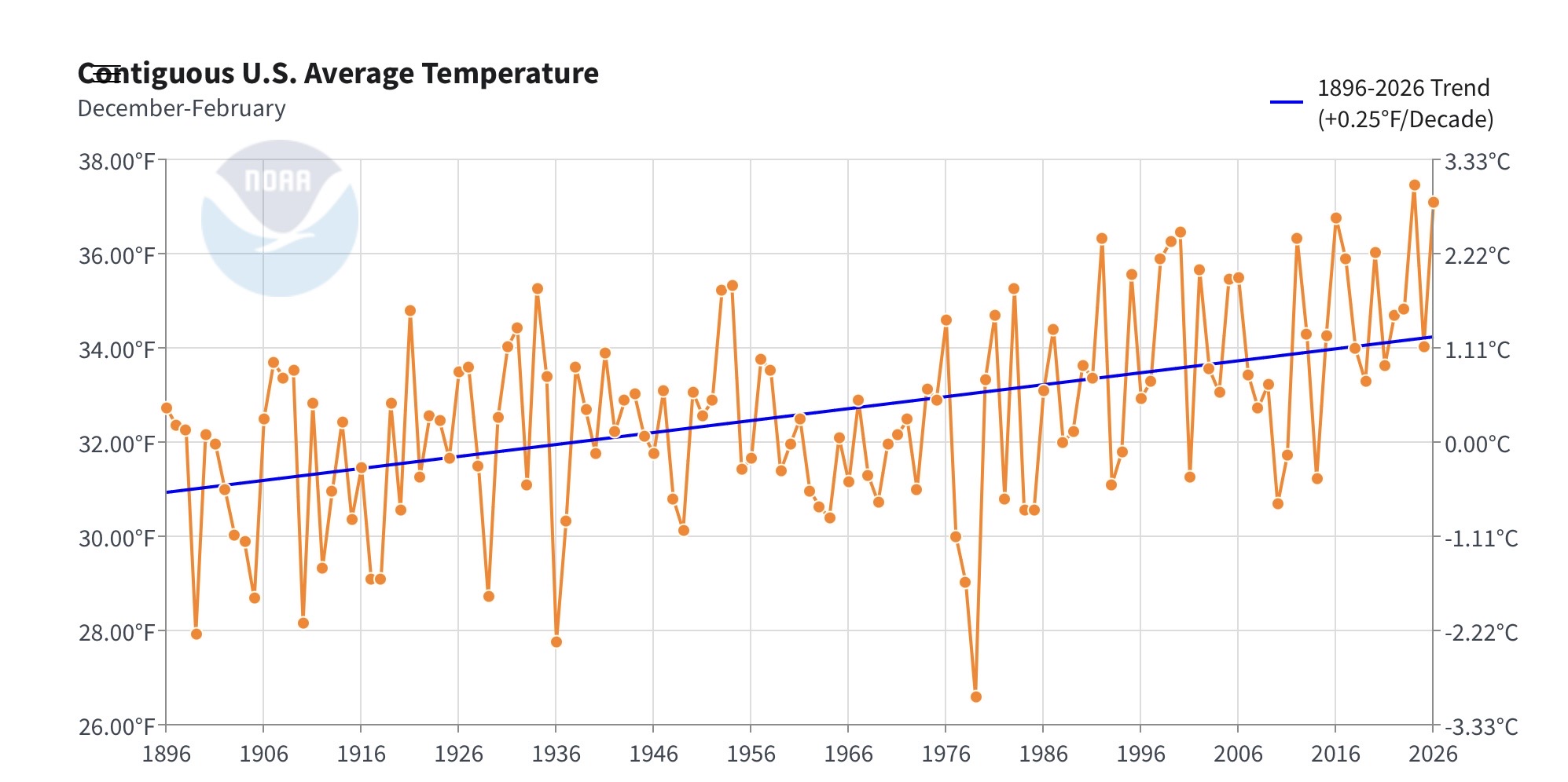
Easily disproved by the actual NCEI adjustments made - see below. Based on what you show above there was no need for cooling from 1941-1946 yet look at what NCEI did...actual raw on left adjustment on left. 47 1940 49.1 47.6 (1.5) 48 1941 53.8 51.6 (2.2) 49 1942 53.6 51.3 (2.3) 50 1943 53.4 50.4 (3.0) 51 1944 53.8 51.2 (2.7) 52 1945 53.6 50.8 (2.8) 53 1946 53.5 51.3 (2.2)
-
Euro ends that 00z run in late January, too ...
-
Just looking at that ... Euro has a 1030-ish high pressure moving from NW to S of NS overnight into Wed AM. GFS does not have that feature. The difference is resisting and/or creating a warm boundary in the Euro - that look is nastier probably in reality on this side of that type of boundary. The GFS has, by an admittedly narrow precarious room for error, a W east stationary front aligned W-E, situated just N of you, which places us all in with the popular kids, movers and shakers. heh. The Euro did not have this two proper cycles ago so... it could be nuanced and fake. However, given to this year's shenanigans? wouldn't be shocker either.
-
Another 1.19" overnight brings April up to 4.04".
-
Forgot about that warm stretch in April 23 where BDL hit 92/96.
.thumb.png.32a8d75c89f8dddcf82b0bfce3835b4c.png)
-

2026-2027 El Nino
Great Snow 1717 replied to Stormchaserchuck1's topic in Weather Forecasting and Discussion
"Best case "scenario as things stand right now is strong...worse case is SSSSUUUPPPEERRR which may obliterate winter in the east. Perhaps on the scale of winter 25-26 in the west. And great point regarding the potential implications well beyond winter 26-27. -
2026-2027 El Nino
40/70 Benchmark replied to Stormchaserchuck1's topic in Weather Forecasting and Discussion
Have you considered the possibility that it may never snow again south of Bridgeport, CT if we get another super El Nino? -
Clear sunrise, but sudden fog in Fairfax City.
-
2026-2027 El Nino
bluewave replied to Stormchaserchuck1's topic in Weather Forecasting and Discussion
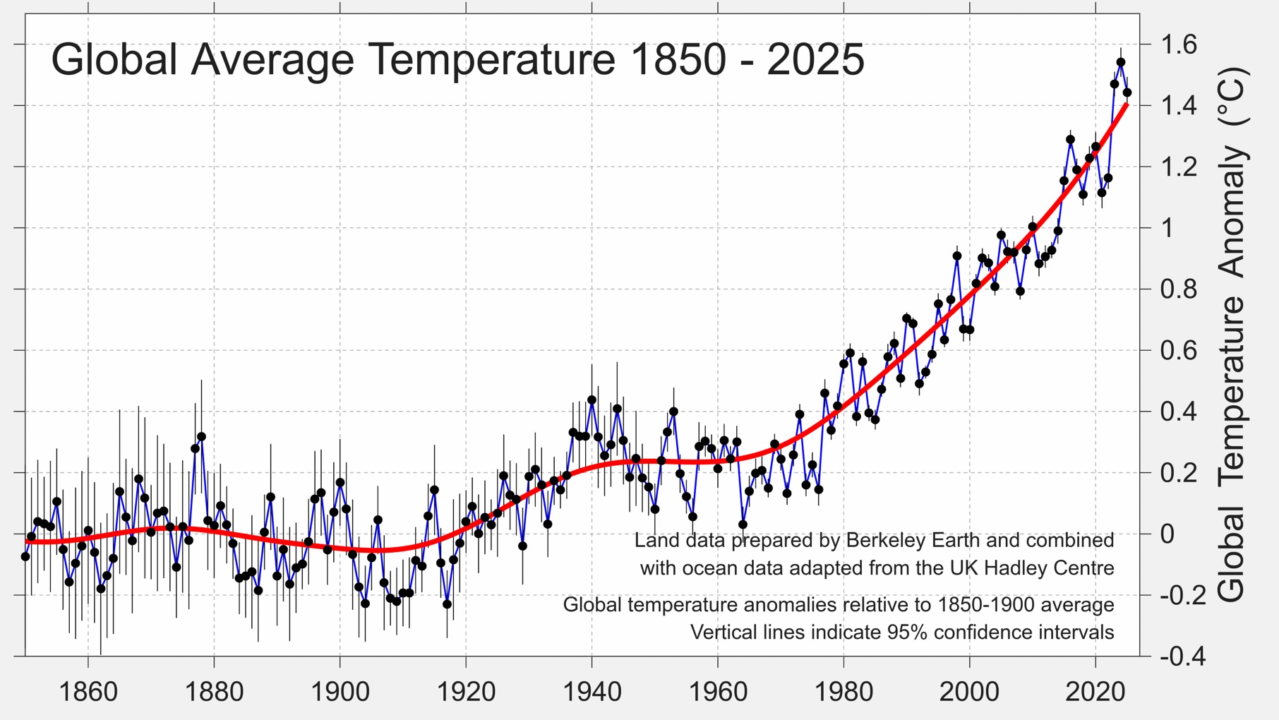
Upper ocean heat is getting off to a record start for March. So the model forecasts of an ONI getting above +2.0° would make sense if the El Niño continues on a similar trajectory into June past the spring forecast barrier. This could be the first ONIs above 2.0° only 3 years apart which could have major ramifications for the global climate well beyond what happens next winter. Since we never had this rapid a global temperature increase over such a short period. With the big temperature jump in 2023-2024 the CONUS has had the #1 warmest winter in 2023-2024 and the #2 warmest winter in 2025-2026. Plus all the record warm winters following the 2015-2016 El Niño.

-
Euro is still a little wedgy up here Wed. Hopefully the gfs wins that.
-
Door and breeze potential next week for a couple of days but overall looks nice.
-
Well that’s CT
-
2026-2027 El Nino
40/70 Benchmark replied to Stormchaserchuck1's topic in Weather Forecasting and Discussion
1982 would actually be a best-case scenario assuming a super El Nino, and may be a favored outcome considering the recent flip to more -WPO in the northern Pacific. It was mild, but had essentially normal snowfall throughout the northeast. I don't mean like 2015, which was good in the mid Atlantic due to one storm, but still sucked in the northeast. -

2026-2027 El Nino
snowman19 replied to Stormchaserchuck1's topic in Weather Forecasting and Discussion
1982-83 was an east-based super El Niño and we had the megalopolis blizzard. That said, I do agree with you that if we do go super, which is looking increasingly likely, it’s going to be a mild winter -
I'll get you something today.
-
Min 32.9° 2023, 2012, and 2010 were pretty warm early off the top of my head.
- Today
-
2026-2027 El Nino
40/70 Benchmark replied to Stormchaserchuck1's topic in Weather Forecasting and Discussion
If we are going to go high end, I just assume the RONI not lag the ONI......I would prefer to take my chances with both in sync and try to pop a huge GOA low. I understand the risks with east-based and such, but keep in mind that I'm conceding a mild winter and am just looking for a window to get a good storm. My largest fear is some El nino/cool ENSO bastard-child, along the lines of 2023 that won't pop a se trough. -
RDU picked up 0.09” on Sunday last week but that was the only measurable rain this month. If models hold and no additional rain is recorded this would move April 2026 into the second driest month ever recorded, behind 0.06” from October 2000.
-
A report from Campbell Hall from Mar 1-3, 2018 would be helpful. I feel like im walking in the dark in some areas with such an extreme snowfall gradient


.png.380400d84460afb9694534fdb81a3bdd.png)