All Activity
- Past hour
-

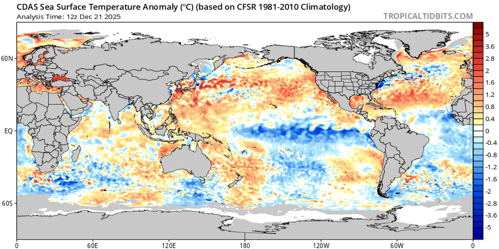
2025-2026 ENSO
40/70 Benchmark replied to 40/70 Benchmark's topic in Weather Forecasting and Discussion
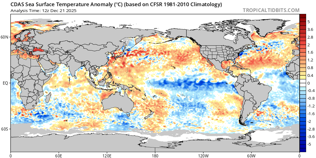
I haven't looked, but any difference in strength is trivial...if anything, this year ENSO should be more favorable because last year was a Modoki, as opposed to east-central this year. The hallmark of the west warn pool has been a consistent strongly +WPO due to the cold being bottled up near Siberia....thia year we have seen a reprieve from that for the first time since 2021-2022. -

December 2025 regional war/obs/disco thread
Snowcrazed71 replied to Torch Tiger's topic in New England
I don't know about this. Eric Webb guy. First of all, La Nina is already starting to fade. Just not buying what he's saying. There's a few other guys that I trust will who dive deep into the pattern with a whole different scenario of what's going to happen. I'm going to let this one just fly out the window. Don't see this outcome as the frontrunner at all at this point. -
Can't really buy a juiced up northern stream s/w on the GFS without some help from the GOM.
-

Possible Light Snowfall (1" - 4") on Tuesday Dec 23
jm1220 replied to Northof78's topic in New York City Metro
NWS needs to either put a dedicated observer there who will do it properly or just use obs from someplace else. -
You’re asking the same questions as I am. I asked him directly as well. The warm pool looks similar to last year unless i’m midreading something. Maybe it’s because the Nina itself looks stronger this year.
-
.thumb.jpg.ad3a2e31d30aff035044689b311a0540.jpg)
Winter 2025-26 Medium/Long Range Discussion
nvck replied to michsnowfreak's topic in Lakes/Ohio Valley
You'll never guess what the new one looks like...BAMWeather(@bam_weather)_X.thumb.jpg.430a616771c8fb3ac29e2985fa47e513.jpg)
-

Possible Light Snowfall (1" - 4") on Tuesday Dec 23
sussexcountyobs replied to Northof78's topic in New York City Metro
8-9 million people in NYC.. Everyone is constantly taking BS selfies and what not on their phone. No one can go to where CP measures, and document it? Is it off limits like Area 51? Ridiculous. -

December 2025 regional war/obs/disco thread
WinterWolf replied to Torch Tiger's topic in New England
Ahh ya..a cutter I’ll do that. Give me a break. -
EPS daily extended ticked colder this run with normal temps into second week of January and with below normal end of January into early February. Control is much colder. Definitely not a "winter is over" run.
-

Possible Light Snowfall (1" - 4") on Tuesday Dec 23
NEG NAO replied to Northof78's topic in New York City Metro
seriously - this official chart contains those inaccurate measurements - not good monthlyseasonalsnowfall.pdf -
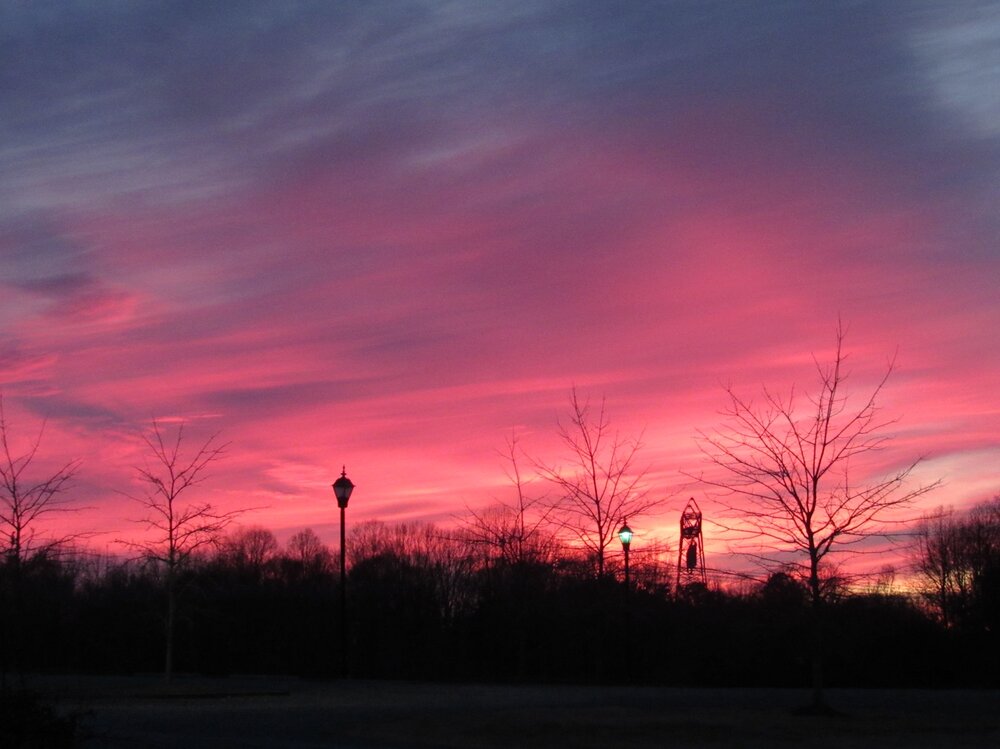
Unedited sunset pic I just took in my neighborhood
-
This is misleading
-

Possible Light Snowfall (1" - 4") on Tuesday Dec 23
Stormlover74 replied to Northof78's topic in New York City Metro
Because they dont think there is a problem -

Possible Light Snowfall (1" - 4") on Tuesday Dec 23
CPcantmeasuresnow replied to Northof78's topic in New York City Metro
Consider that the official Measurer, or whatever title you want to give him, was the Central Park Zookeeper from 1992-2014. A period of some of the worst under measured storms of all time. They handed it off to the Conservancy and from 2015-2019 it improved quite a bit. Since 2020 they have been as bad as the zookeeper was. -

Possible Light Snowfall (1" - 4") on Tuesday Dec 23
North and West replied to Northof78's topic in New York City Metro
They’re in bed with Big Melt. . -

Possible Light Snowfall (1" - 4") on Tuesday Dec 23
WeatherGeek2025 replied to Northof78's topic in New York City Metro
Central Park always under measures! How is that even legal!? -

December 2025 regional war/obs/disco thread
Boston Bulldog replied to Torch Tiger's topic in New England
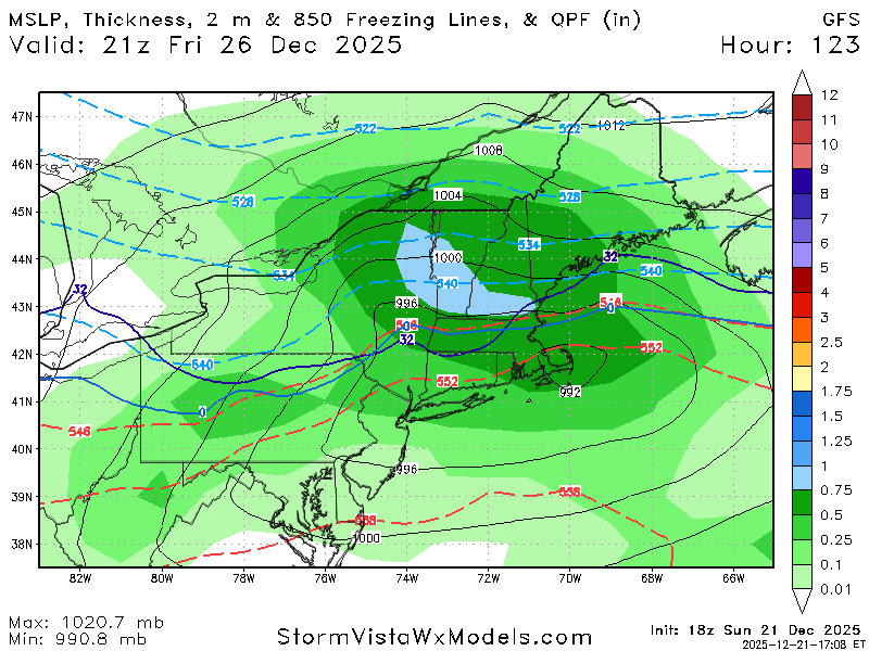
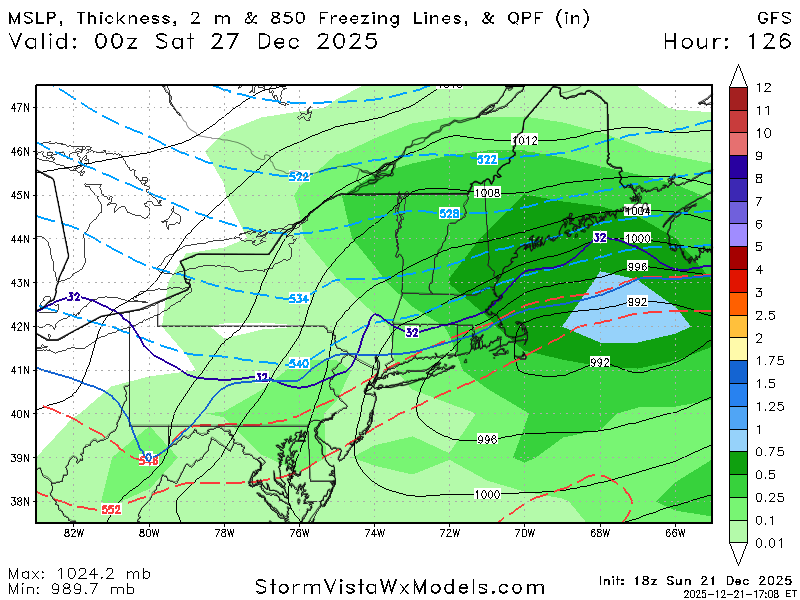
18z GFS is probably the ceiling for this event in terms of intensity and snowfall totals. There would be some powerful zonally translating mid-level snowbands across CNE and NNE with that dynamic look. Verbatim a high end SWFE that successully jumps to the coast to lock in cold air For more snow further south, we would need destructive interference to attenuate the shortwave a bit. A scenario like the Euro is still a good storm, but it's not a nuke like this GFS look. -
Possible Light Snowfall (1" - 4") on Tuesday Dec 23
NEG NAO replied to Northof78's topic in New York City Metro
then why hasn't the problem been solved and corrected ? -

December 2025 regional war/obs/disco thread
WxWatcher007 replied to Torch Tiger's topic in New England
We love to see it. -
That's a lot of snow up here.
-
Possible Light Snowfall (1" - 4") on Tuesday Dec 23
sussexcountyobs replied to Northof78's topic in New York City Metro
This is not rocket science. It's pretty simple. -
December 2025 regional war/obs/disco thread
WxWatcher007 replied to Torch Tiger's topic in New England
Absolute nuke in NNE. Icing down into CT. at the surface temp cave from the 12z run -
Yep
-
GFS going for a ice storm
-
Possible Light Snowfall (1" - 4") on Tuesday Dec 23
NEG NAO replied to Northof78's topic in New York City Metro
I think it has to be an employee of the NWS - anyone on here live near Central Park and can measure close to where they get their measurements from ? maybe Walt has some more info on the measurements and why they are always low


BAMWeather(@bam_weather)_X.jpg.f9f68a607f047ac529337f5bb8b76a04.jpg)


