All Activity
- Past hour
-
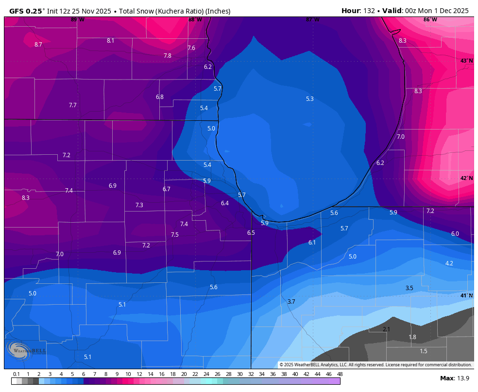
Def a lot lore interesting on GFS for 12/2-12/3. Still selling that even for now…early if it happens.
-
That ext Euro phase 8 lasts 11 days, which would be the longest in Dec since 1975. I just hope it actually gets there and stays for awhile rather than curl back to 7 to stay.
-
Rather have a juiced STJ and storm chances vs the northern stream dominant during Nina’s. That causes SWFE/cutter favored patterns and Miller Bs that can develop too late. I’d say I-84 is the cutoff for where Nina is a better winter on average vs Nino.
-

2025-2026 ENSO
michsnowfreak replied to 40/70 Benchmark's topic in Weather Forecasting and Discussion
The orientation of temp departures this November is absolutely nothing like the top 3 warmest novembers. -

Nov 28-30th Post Turkey Day Wintry Potential
Radtechwxman replied to Chicago Storm's topic in Lakes/Ohio Valley
Wouldn't surprise me. WAA usually wins. But still several days out. A lot can change. For better or worse -
God luck with that. This is basically every run of the GFS in the longer range...
-
its not impossible - we are heading into a more favorable pattern for cold/snow events - it has snowed during this time period many times before - worth tracking for sure..........
-

Nov 28-30th Post Turkey Day Wintry Potential
DocATL replied to Chicago Storm's topic in Lakes/Ohio Valley
Gonna be rain by tomorrow’s runs isn’t it? -
Nov 28-30th Post Turkey Day Wintry Potential
Radtechwxman replied to Chicago Storm's topic in Lakes/Ohio Valley
Amen. Riding team euro till end -
Seems awfully cold for a torch?
-
Dont bet on Nino if you live in NYC. Like putting money on the Jets. 2015-16 is a perfect example. Whole season in one giant storm. They could beat the Patriots; but dont bet on it It also messes up the ski season in a big way
-

Nov 28-30th Post Turkey Day Wintry Potential
migratingwx replied to Chicago Storm's topic in Lakes/Ohio Valley

-

December 2025 regional war/obs/disco thread
40/70 Benchmark replied to Torch Tiger's topic in New England
Looks like December 6th it is. -
Nice little event
-
 And there you go again .. always talking about someone's junk. Hmmmmm.
 -
Its coming back

-

November 2025 general discussions and probable topic derailings ...
ineedsnow replied to Typhoon Tip's topic in New England
GFS trying to make DC to SNE festive next week -
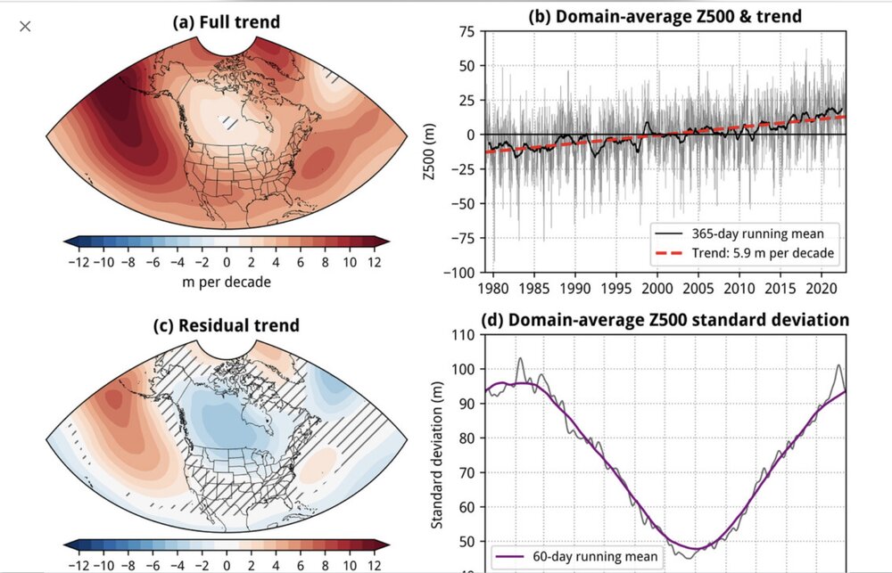
Yeah, there’s no doubt that the warming climate is increasing the size of the SE ridge regardless of whether it gets over or under modeled. Ridges are getting larger and the breadth of below normal temps from troughs is getting smaller. These are just facts. doesn’t mean it can’t snow or get cold though. But in terms of getting the colder temps, it’s like spinning a prize wheel with less winning spaces to land on.
-
They do exist: https://www.caranddriver.com/kia/ev4
-
-
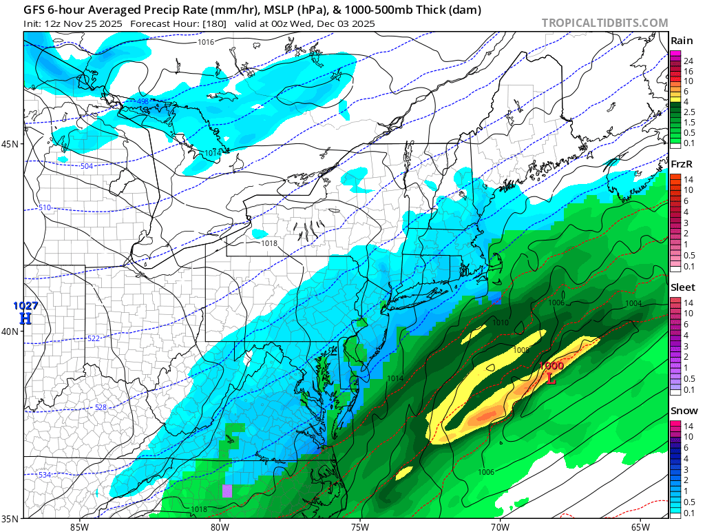
Man that first week torch in December really went away. Snow on the doorstep at 165 of the GFS.
-
Looks like they're starting to come into general agreement for a quick 1-3" for much of the Front Range with the cold front Friday overnight.
-
Plus we are talking about the long term increasing influence of the Southeast or Western Atlantic ridge on our sensible weather.
-
I will take warm winter with a cold storm track over a cold or near normal winter and a warm storm track.
-
Fair but we also don’t verify a forecast with a forecast.