All Activity
- Past hour
-
When Don is posting kuchera maps…
-
is that near hampshire hill?
-

E PA/NJ/DE Winter 2025-26 Obs/Discussion
Ralph Wiggum replied to LVblizzard's topic in Philadelphia Region
Ens means arent budging much. Thats a red flag for up here and a sweet signal for the Mid Atl. -
It's a 20yd FG attempt. you can't miss.
-
No stress.
-

Central PA Winter 25/26 Discussion and Obs
MAG5035 replied to MAG5035's topic in Upstate New York/Pennsylvania
I had to quick delete because I pulled a rookie move and posted/commented on what was last nights UKMET haha. I’ll be very curious if the Euro continues to move its heavy snow swath our way. Regardless, I’m not anywhere near sweating the too far south/north solutions. But this energy has to all come out and not have a portion of it left behind like what the GFS has been trying to do. I think as long as that happens I like our chances. -
Yeh. A foot plus from Murphy to Manteo. That’ll work. .
-
lol I’m dead
-

January 2026 regional war/obs/disco thread
ORH_wxman replied to Baroclinic Zone's topic in New England
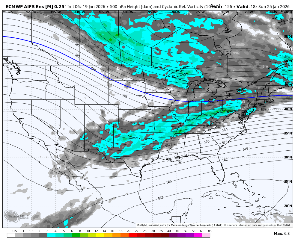
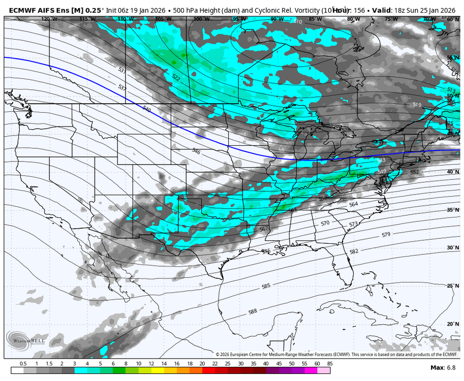
GEFS def came north a bit from 06z. There’s some hits in there now while 06z had almost unanimous whiffs. The risk is obviously suppression on this but it’s far from a done deal. PV is crazy cold with the press but it’s also moving NE with time and we don’t have quite the crazy exotic west based block like a Feb 2010…EPS is more bullish on the blocking which has kind of been a theme this winter -

January 2026 regional war/obs/disco thread
40/70 Benchmark replied to Baroclinic Zone's topic in New England
If you recall my sentiment leading into that one, different ballgame. I started the thread and had my balls busted for doing so. -
Not sure why I feel like a FG kicker in a tie game with the Super Bowl on the line
-
i'd be getting excited down here. this has all the hallmarks of a mid-Atlantic MECS (up by me is less certain for sure)... ample moisture, strong 250mb jet, some phasing potential, antecedent Arctic air, and confluence in place
-

Texas 2025 Discussion/Observations
aggiegeog replied to Stx_Thunder's topic in Central/Western States
Looks like we are in for an epic winter storm this weekend across much of Texas. Front crashes through on Friday turning rain to freezing rain north to south Friday into Saturday. Areas along and north of I-20 may get lucky and its more sleet and snow. Along and north of I-10 looks very icy. Snow and mixed showers extend into Sunday morning for east and SE TX. Monday lows across N and NE TX could well approach 0. More snow or mix could be in the cards for the middle of next week also. -
That would still be my biggest snowfall in 10 years! If that would be a "fail" scenario, then that would be a heck if a consolation prize.
-

Winter 2025-26 Short Range Discussion
WestMichigan replied to SchaumburgStormer's topic in Lakes/Ohio Valley
It is pretty crazy out there this morning. 100-car pileup reported on I-196 in Hudsonville area | WOODTV.com -
I would even take 8" if it meant us getting a MECS.
-
January 2026 regional war/obs/disco thread
40/70 Benchmark replied to Baroclinic Zone's topic in New England
I don't think you will get 2 feet like the mid atlantic, but certainly warning potential. Different story for me. This seems like a PD I or feb 2016 deal. -
My bench mark for this is a 6" - 10" event. Would be the biggest snowfall for me since moving back to Maryland in August 2016.
-
-

-

January 2026 regional war/obs/disco thread
WinterWolf replied to Baroclinic Zone's topic in New England
Yup, they’re in very good shape now. Looking forward to it for sure. -
January 2026 regional war/obs/disco thread
40/70 Benchmark replied to Baroclinic Zone's topic in New England
Book it. -
We would all take 8 in a heartbeat.
-
Yea 12z Thursday is my go/no go for this event. I'd much rather deal with suppression than worrying about something cutting. With such a fresh, strong push of cold air coming I don't think we have to worry about this cutting too much this time.
-
January 2026 regional war/obs/disco thread
WinterWolf replied to Baroclinic Zone's topic in New England
Yup, said that a few posts back. At least as of now. It certainly could get shunted for sure. But there’s a shot it creeps north for sure.