All Activity
- Past hour
-

Strong Nor'Easter/Hybrid Storm Late September 2026
jbenedet replied to Rjay's topic in New York City Metro
Pretty clear on the guidance that the evolution is mid lat cyclone to STC to tropical warm core/STC. -

October Comes Early: Late September Multi-Hazard Hybrid Storm
LSC97wxnut replied to WxWatcher007's topic in New England
How many named naked swirls have we seen over the years? In the eyes of those who know better, should this count? -

Strong Nor'Easter/Hybrid Storm Late September 2026
guinness77 replied to Rjay's topic in New York City Metro
lol already got branches down in my neighborhood. Canceled a reservation for our 20th anniversary dinner in Bay Shore that was supposed to be at 8pm tomorrow because that area floods rather easily, forget in a storm like this. Lol it’s always friggin something ugh. -

Strong Nor'Easter/Hybrid Storm Late September 2026
Snowlover11 replied to Rjay's topic in New York City Metro
I wouldn’t wanna be flying in this wind i dont mind flying but hate turbulence lol -

Septorcher 2026 Discussion - Endless Summer
Typhoon Tip replied to Damage In Tolland's topic in New England
this next Wed - Sat looking increasingly WAR -like in the GFS's recent guidance... 00z, 06z and 12z runs GGEM's sort of coming around. Euro thinks ala carte mid November -

Strong Nor'Easter/Hybrid Storm Late September 2026
Brian5671 replied to Rjay's topic in New York City Metro
You will see delays for sure. They are so busy that even a run of the mill storm causes delays -

Strong Nor'Easter/Hybrid Storm Late September 2026
bluewave replied to Rjay's topic in New York City Metro
Yeah, the mean tide forecast tomorrow for the GSB is just below the Hurricane Irene mark which maxed out at the +5.5 level.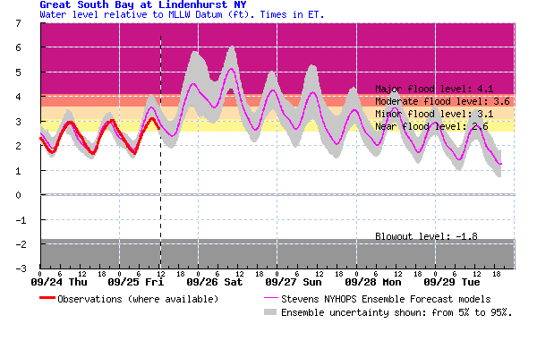
-

Strong Nor'Easter/Hybrid Storm Late September 2026
TriPol replied to Rjay's topic in New York City Metro
Jesus. A hybrid storm taking the same path Sandy took. More rain, much smaller wind field. -

Strong Nor'Easter/Hybrid Storm Late September 2026
Intensewind002 replied to Rjay's topic in New York City Metro
Was gusting around forty here earlier, a friend of mine told me there was a wire down on wellwood ave in Lindenhurst already -

October Comes Early: Late September Multi-Hazard Hybrid Storm
CCHurricane replied to WxWatcher007's topic in New England
mm/hr -

Strong Nor'Easter/Hybrid Storm Late September 2026
mob1 replied to Rjay's topic in New York City Metro
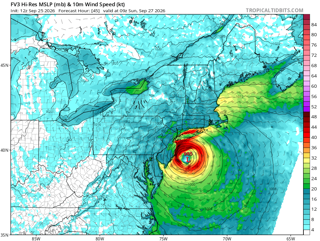
This is the track that'll yield the worst winds and coastal flooding. The models that have it go over the NY harbor or so are less extreme (this is obviously especially true for the central NJ coastline.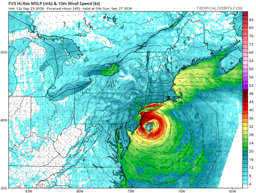
-

Strong Nor'Easter/Hybrid Storm Late September 2026
qg_omega replied to Rjay's topic in New York City Metro
long range meso HRRR and NAMs did -

Strong Nor'Easter/Hybrid Storm Late September 2026
GaWx replied to Rjay's topic in New York City Metro
What about airport service on Sun/Mon at the 3 major NYC area airports? How did past comparable storms affect service? -

October Comes Early: Late September Multi-Hazard Hybrid Storm
WinterWolf replied to WxWatcher007's topic in New England
James? James, is that you? -

October Comes Early: Late September Multi-Hazard Hybrid Storm
WxWatcher007 replied to WxWatcher007's topic in New England
Given how close to the coast it is modeled to get, I think so eventually—whether initially along the NJ coast or when it’s weaker and moving NE over part of New England. -
Strong Nor'Easter/Hybrid Storm Late September 2026
TriPol replied to Rjay's topic in New York City Metro
You mean issuing evacuations? There's not enough time. Absolutely NO model had this slamming into central NJ 48 hours ago. Not even the EURO or EURO AI. -

October Comes Early: Late September Multi-Hazard Hybrid Storm
DirtySnowDen replied to WxWatcher007's topic in New England
The eyewall did not disappear. It’s working on itself, you can see the inner cloud wall developing. -
Strong Nor'Easter/Hybrid Storm Late September 2026
TriPol replied to Rjay's topic in New York City Metro
Well, there won't be much subway service Monday morning if that verifies. -

Strong Nor'Easter/Hybrid Storm Late September 2026
Michael05192016 replied to Rjay's topic in New York City Metro
Sandy lite v.2 - "Sandy's weaker cousin" -
Strong Nor'Easter/Hybrid Storm Late September 2026
Brian5671 replied to Rjay's topic in New York City Metro
Agreed-a few days ago the track suggested north winds now it's NE or even ENE -
2026-2027 Record-breaking El Nino
Typhoon Tip replied to Stormchaserchuck1's topic in Weather Forecasting and Discussion
I did not lol ... 12z GFS looks even warmer... By that, just less obstructed in general. 570+ DM thickness both Thu and Fri, with 582 non-hydrostatic isohypsis situate NW of ALB ... It's actually looking more more WAR-like -
October Comes Early: Late September Multi-Hazard Hybrid Storm
DirtySnowDen replied to WxWatcher007's topic in New England
Will this thing actually make a landfall or meander just south of LI/NJ ? -

Strong Nor'Easter/Hybrid Storm Late September 2026
MANDA replied to Rjay's topic in New York City Metro
I'd also keep an eye on western L.I. Sound. Depending on exact wind trajectories water could be piling into the west end of the sound. Been concerned about that for several days. As of now forecasts are for mid range moderate but room for higher if the winds can go more ENE for a time. Just something to watch. -
Great. Just fn great.
-
Spinning wheel