All Activity
- Past hour
-
.thumb.jpg.6a4895b2a43f87359e4e7d04a6fa0d14.jpg)
Central PA Fall Discussions and Obs
Yardstickgozinya replied to ChescoWx's topic in Upstate New York/Pennsylvania
Ok i'm gonna let it dangle. 8.8 inches over the next 45 days probably isn't going to happen, but it's also not that unachievable. I don't think anything on that graphic looks that outrageous. Plenty of places could easily be able to hit those numbers over the next forty five days. Now all that 8.8 sticking around over that time period or actually having that much on the ground in forty five days is unlikely. -
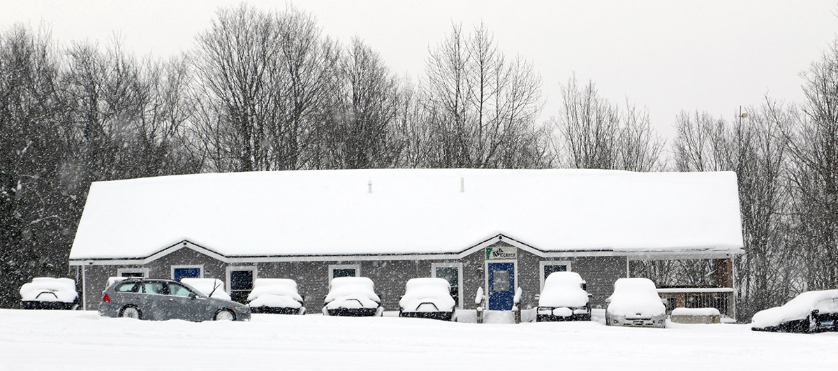
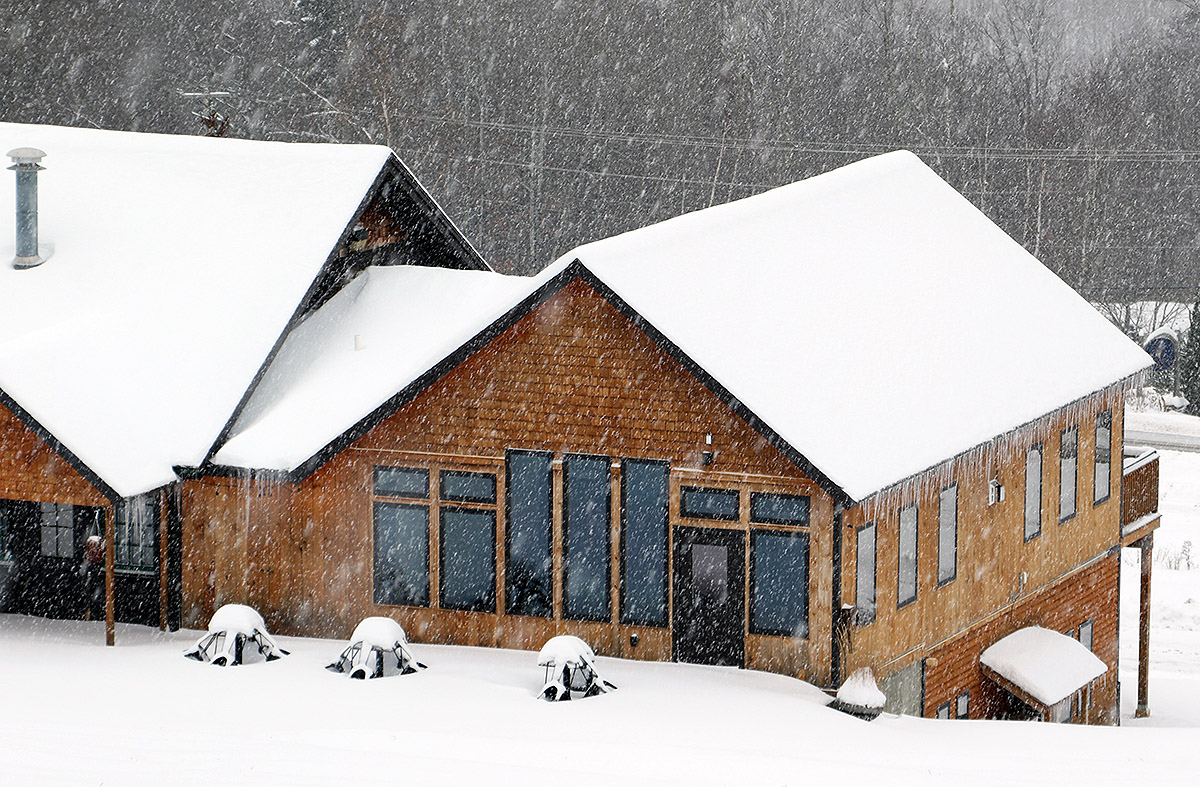
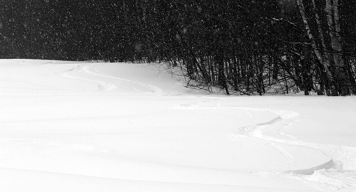
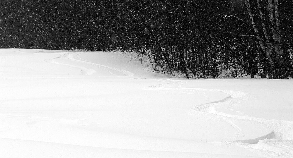
That shot is a great representation of what’s been going on out there. I was busy yesterday as well, but I was able to swing by Bolton for a quick tour to check out the snow from the back side of the system. I was going to head up to the main base, which has been the way to go so far this season with its overall deeper snowpack, but I passed by Timberline and could see that the snow looked great even down to 1,500’, so I figured I’d save some time and tour there. Right at base lodge level I was getting snow depth readings in the 15-20” range, and part of that is consolidated base, so I could tell that all the terrain would be good to go. I have no idea what the snow depths are up above 3,000’, but with the snow depth at the Mt. Mansfield Stake sitting around 40”, it’s probably getting close to that mark in Bolton’s higher elevations as well. Anyway, Saturday offered up some great skiing, but yesterday’s skiing was next level because of the new powder that fell. Up to this point in the season, I’d say my outing back on the 6th had offered the best quality turns, but it certainly takes a back seat to yesterday. My snow analyses from the back side of the system gave an average of 6.0% H2O, and it was set up perfectly with a right-side-up gradient atop the denser snow below. If I rated Saturday’s skiing as a 6 out of 10, then yesterday was up around 9 out of 10. I guess a way to improve it would be to go even deeper, but 1 to 2 feet of 6% powder with a density gradient beneath it is way up there in quality – the turns were just effortless, and you really couldn’t go wrong. Those are stellar ski conditions for any time of the season, but it’s especially notable for mid-November. As I was floating down through the champagne on the Twice as Nice trail, one thing that struck me was that many ski areas in the country might not even have a day all year with such primo conditions. There was actually only one other car at Timberline for the entire time I was there. It was a father and son out for some touring, and the son had already had hockey practice that morning, so this was his next activity of the day. There’s nothing like getting in two sports before it’s even lunch time. The dad, Willie, saw me taking some pictures and when I confirmed who I was, he introduced himself as a fan of our website, so it was fun way to meet another couple of Bolton Valley regulars.


- Today
-
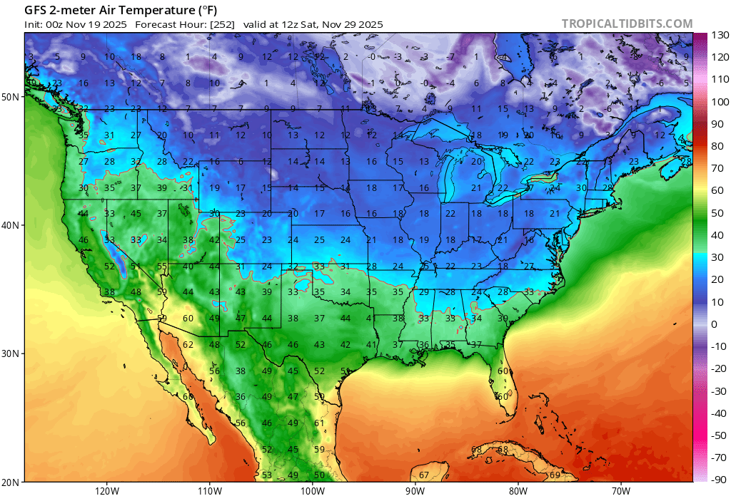
How much snow did Baltimore get during the 13 phase 7 Dec periods that were during La Niña? I’ll check now: 12/16-19/1974 (temps 1 AN): 0.4” 12/7-9/1988 (temps 1 BN): 0.8” 12/23-25/1988 (temps 5 AN): none 12/9-19/1995 (temps 7 BN): 1.5” (3 snows) 12/20-23/1998 (temps 4 AN): 3.0” on 12/23, which was very cold 12/20-30/1999 (temps 3 BN): 0.2” 12/11-14/2000 (temps 5 BN): T 12/14-21/2008 (temps 2 AN): T 12/16-20/2010 (temps 11 BN): 1.2” 12/9-11/2017 (temps 5 BN): 2.8” 12/17-20/2017 (temps 5 AN): none 12/19-31/2021 (temps 7 AN): T 12/28-31/2024 (temps 13 AN): none ———- From this list: -Temps averaged right at normal -9.9” snow over 77 days or on avg 0.13”/day How does 0.13” snow per day of phase 7 in Dec La Niña compare to all of 1974-2025 Dec climo at Baltimore? They averaged 2.2”/Dec 1974-2025 or 0.07”/day. Compare the 0.13”/day to 0.07”/day: that’s 185% of the average for all Dec days since 1974 and the conclusion is that Baltimore did quite well overall with snow during phase 7 in Dec for La Niña vs the avg for all Dec days. @stadiumwave
-

November 2025 general discussions and probable topic derailings ...
dendrite replied to Typhoon Tip's topic in New England
I didn’t mean a cold SWFE. But when we’re hanging on to the wedge here near freezing you often mix out in the SE downslope up there. Remember, the primary goes to our west in these and we don’t always get redevelopers south of us. -
https://x.com/webberweather/status/1990921925745410375 Webb says the tropical troposphere is already El Nino like. I wonder if this is playing into the strengthening trends for the MJO mentioned above.
-
 2020-21 is my only near normal snowfall year. It was good one. Feb ‘24 might be one of my all time favorites. I read through that thread every so often to remind myself that miracles do happen.
 -
Seems that way, at least in the boundary, but it might stay dry. Anything very light would probably be liquid.
-

November 2025 general discussions and probable topic derailings ...
Torch Tiger replied to Typhoon Tip's topic in New England
-

November 2025 general discussions and probable topic derailings ...
MJO812 replied to Typhoon Tip's topic in New England
Yep and now the gfs brings winter before Dec 1

-

November 2025 general discussions and probable topic derailings ...
WinterWolf replied to Typhoon Tip's topic in New England
Lol It keeps on creeping colder. -
November 2025 general discussions and probable topic derailings ...
WinterWolf replied to Typhoon Tip's topic in New England
Yup…then Feb 1st of ‘21 we had a very good one(double digits). Then Feb of ‘24 I got the 13” surprise that was supposed to be 1-2”. That storm saved that winter(ended up with 25” for the season total) from being as bad as 22-23 was(which had 12.5” for the season). -
Cold air comes in quicker next week by Turkey day .
-
Same as black Friday. Cold air comes in quicker.


-
November 2025 general discussions and probable topic derailings ...
MJO812 replied to Typhoon Tip's topic in New England
Turkey day colder on the gfs compared to 18z -
I’d call it average. At Baltimore since 1974 during 3+ day long phase 7 periods during Dec (32 of them adding to 185 days), they’ve averaged 0.5 F warmer than normal with the coolest tending to be somewhat weak and warmest tending to be somewhat strong though with much variation. The range during La Niña has been as cold as 11 BN (12/16-20/2010), 7 BN (12/9-10/1995), and 5 BN (12/9-11/2017) to as warm as 13 AN (12/28-31/2024) and 7 AN (12/19-31/2021). Breakdown of these 13 phase 7 periods during La Niña in Dec: 1 MB, 4 B, 2 N, 5A, 1 MA
-
Gfs has gotten colder for Thanksgiving
-
December ‘20 was great here. The one of the two 12” events since 2018-19. Of course…just a few weeks later we had King Grinch. That’s what I want to avoid. More than I want a big December snow.
-

E PA/NJ/DE Autumn 2025 Obs/Discussion
LVblizzard replied to PhiEaglesfan712's topic in Philadelphia Region
Hi-res RGEM has 6” for much of Northampton County tonight. Would be pretty wild to see that model score a coup. Looks like other models are much more realistic with a C-2” north of I-78. -
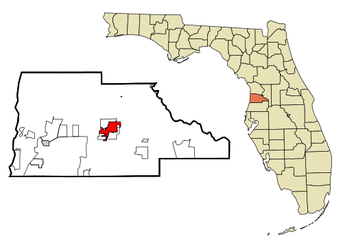
That’s pretty amazing considering that Brooksville, FL, got down to an incredible 27 on Nov 12th!! Here’s where Brooksville is located, well on down into C FL! To be fair though, elevations are 100-180 feet, quite high for FL.
-
Phase 7 in DEC is usually a decent phase though??
-
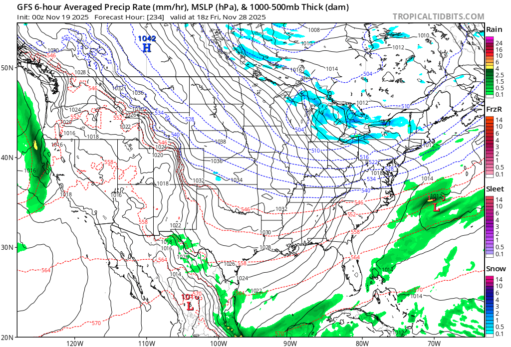
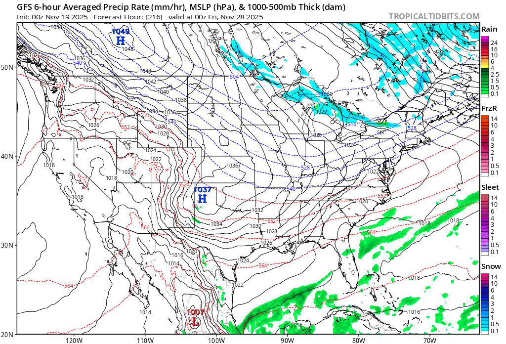
This storm looked pretty good on paper. Part of the atmospheric river of systems moving through the southwest. It’s even generated rain in Vegas.
-
Just popped into radar and am surprised at what I see. Will see if it maintains over the mountains. From my experience we usually get it when it comes up from the SW more than directly from the W.
-

November 2025 general discussions and probable topic derailings ...
powderfreak replied to Typhoon Tip's topic in New England
It all ebbs and flows... you get into ruts, or into great runs... up this way, we couldn't open until December last season. This season it is record breaking snow in mid-November. More snow on the ground now than there was during the entire 2015-2016 season in the mountains. The natural variation in weather patterns is pretty crazy year-to-year... and especially over decadal periods. -

November 2025 general discussions and probable topic derailings ...
weathafella replied to Typhoon Tip's topic in New England
All through the late 1950s and 60s. -
Early returns on 0z snow a shift south and drier for NJ and points east. HRRR, RRFS, NAM, and RGEM show a similar trend. Converging on I-80 with a tenth or two of precip (regionally) in the snow-supporting column. Our "stuff" is still back in WPA. It may blossom into CPA over the next few hours.