All Activity
- Past hour
-
ACATT . You just laugh at them at this point . Continue to embarrass themselves . It’s really only one of them, The others finally admitting how hot it’s been and continues to look well into fall
-

Hurricane Erin: 125 MPH - 940mb - WNW @ 14
A-L-E-K replied to BarryStantonGBP's topic in Tropical Headquarters
Shame about the fish storm -

Hurricane Erin: 125 MPH - 940mb - WNW @ 14
jconsor replied to BarryStantonGBP's topic in Tropical Headquarters
Thanks man! Appreciate the encouragement and positive feedback. I expect to post an update today. -
 76 / 70, Partly cloudy, although some paerts of the area have clouds into N/NW NJ. Hottest day out of the next week to 10 days, at least. Low to mid 90s in the hottest areas, ahead of any clouds and scattered showers with the boundary later. Cooler, cloudy Monday and stuck in the 70s unless there is some overnight maxes (midnight/1AM). Onshore barrage this week as Eric passes by out to sea, perhaps some scattered showers/ rain / storms Tue - THu , otherwise mainly dry and near to slightly below normal. Flow comes around to warm up Fridy and next weekend, and with continued drying, the next chance at 90 in the hotter areas. Trough into the east by the 26 with ridge building east by the close of the month and warm overall beyond there. 8/17 : Hottest day for a while 8/18 - 8/21 : Cooler , mainly dry 8/22 - 8/24 : Brief warmup with chance for 90 (Fri/Sat in the hottest areas 8/25 - 8/29: Cooler 8/30 - Beyond : Overall warmer - Wet ridge building back eat
 -
Amazing how my area south of ATL only got 4.96" in the last 90 days!!! And 4.85" was just this month alone.
-
Actually I was confused. Posted in the wrong thread earlier.
-
Meh
-
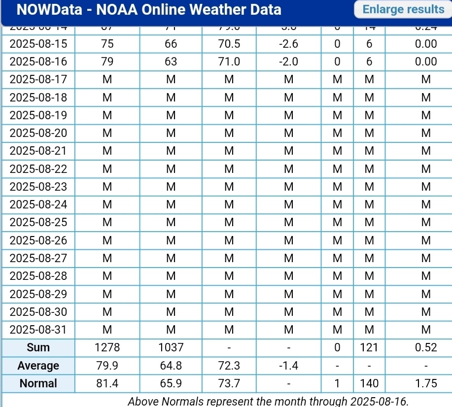
ORH is 1.2 above. lol. After all the dong slapping for a cool start.
-
Surf?
-
What @BlizzardWx posted yesterday makes the most sense….recurving hurricane/well above normal ACE tropical seasons during -ENSO’s are a symptom of an overall Atlantic background state resulting in -NAO blocked winters…..not the cause of them
-
Today near 90 and next weekend too imo as long as it doesn’t rain. What a stretch we’ve been in. Definitely cools down this week.
-
From NWS State College: Today will likely be the warmest day in the next 7 (maybe for the rest of the month?) with max temps peaking +5-10 degrees above the historical average for mid/late August in the mid 80s to low 90s across the central ridges and mid/lower Susquehanna Valley.
-
Heat stroke
-

Central PA Summer 2025
Mount Joy Snowman replied to Voyager's topic in Upstate New York/Pennsylvania
Low of 71. I’m about to go golfing. Stick a fork in me. Thankfully a major pattern change on the way for tomorrow. -

2025-2026 ENSO
PhiEaglesfan712 replied to 40/70 Benchmark's topic in Weather Forecasting and Discussion
All you need to know is that 1950-51 destroys the whole theory. 1950 was the 5th highest ACE season (8th on NOAA, 2nd on Wunderground - behind the historic 2005 season: https://www.wunderground.com/hurricane/articles/most-active-hurricane-seasons), and that season only produced 4.6 inches of snow at PHL. -
While the sample size is pretty small, there has been an increase in NYC La Niña snowfall following Atlantic hurricane seasons with 160+ ACE since 1995. There was also an increase in December +PNAs. Unfortunately, the relationship didn’t work last winter due to the overpowering Northern Stream of the Pacific Jet. Last season was the first with only 12.9” of snowfall in NYC with a strong December +PNA and a La Niña. My guess is that the high ACE was part of a similar pattern which used to produce both December +PNAs and snowy outcomes during La Nina’s. So while we got the strong December +PNA last season, the snowfall didn’t follow due to the warm storm track through the Great Lakes. So several elements in the same pattern but we can’t say that the ACE is directly the cause. Just that these elements appear together from time to time. It could be they are related to another underlying variable that we haven’t identified yet. 2005….ACE…..245….DEC PNA….+1.38….NYC snowfall….40.0” 1995….ACE……227….DEC PNA…..+0.92..NYC snowfall ….75.6” 2017….ACE……224….DEC PNA…..+0.89…NYC snowfall….40.9” 1998…ACE……181……DEC PNA…..-0.09….NYC snowfall…..12.7” 2020..ACE……180…..DEC PNA…..+1.58….NYC snowfall….38.6” 1999…ACE……176…..DEC PNA……+0.21….NYC snowfall…..16.3” 2010…ACE…..165……DEC PNA…….-1.78….NYC snowfall…..61.9” 2024…ACE….161……DEC PNA…….+1.70….NYC snowfall…..12.9”
-
going to be a fun winter building strawman and tearing them down
-
Torch Tiger seems confused.
-
Today near 90 and next weekend too imo as long as it doesn’t rain. What a stretch we’ve been in. Definitely cools down this week.
-
Hottest August ever lolz. Where do people come up with this stuff?
- Today
-
A bit of fog here in Templeton this morning.
-
NHC noting the possibility of some impacts 4. Interests along the North Carolina and Mid-Atlantic coasts, and Bermuda should monitor the progress of Erin as there is a risk of strong winds associated with the outer rainbands during the middle part of the week.
-
Met summer here is stuck at 3.93". Average thru August 16 is just over 11".
-

Hurricane Erin: 125 MPH - 940mb - WNW @ 14
RevWarReenactor replied to BarryStantonGBP's topic in Tropical Headquarters
Anymore shifts and outer banks could be looking at some fringe effects. -
We were on the verge of drought imby when I left, glad to see the multi year just in time rains trend continue