All Activity
- Past hour
-
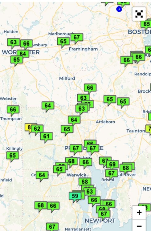
 Skies getting brighter here and up to 72.
 -
Yep. It was a great summer for swimming in it, but it is drawing to a close. Much better than last year.
-
Unless you have a solar blanket, Temps really fall off at night now and you lose ground.
-
Only 65 here. My pool…
-
 Had to look at the calendar today. Is it August or October? Odd
 -
Yes, I noticed that on the beach with blowing sand. Please take a video and post it if you can.
-

Hurricane Erin: 105 MPH - 945 mb - NNE @ 17
Chinook replied to BarryStantonGBP's topic in Tropical Headquarters
direct measurement of winds east of Hatteras -
this is our year
-
so, you’re not a bot.
-
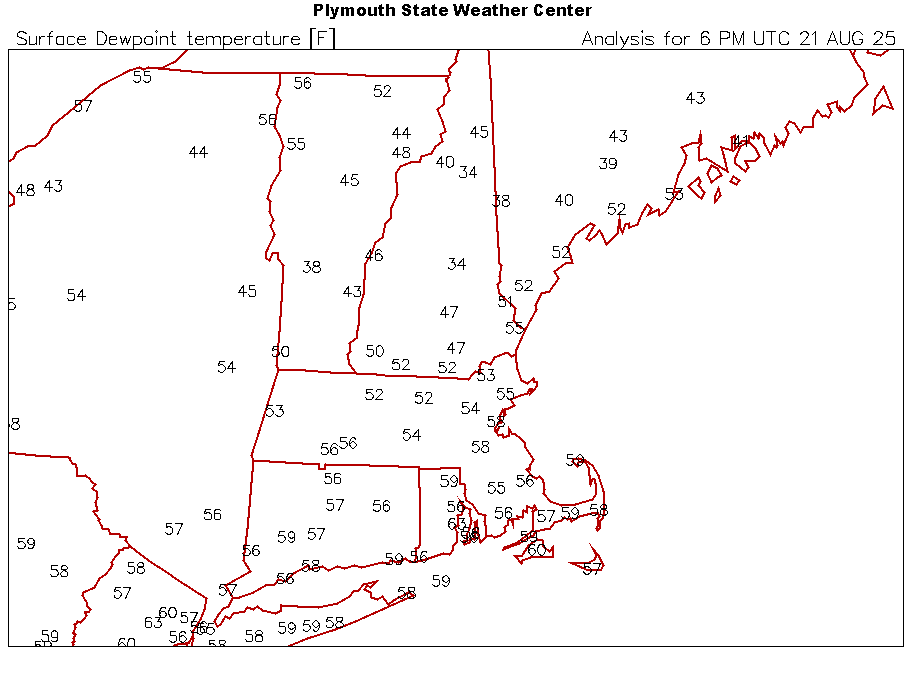
73/45°F, This is pretty fall like weather.
-
Those +3, +4 departures from 10 days back wiped clean after these last few days.
-
We are down at the other end of the island, near the border with diamond beach. My grandparents bought a house in Wildwood in the 70s but then the family 'upgraded' to Wildwood Crest in the 90s. "wild situation" sums it up here today... I will go back down at high tide and try to get more pics and vids as the surf continues to build up. The wind is tolerable standing on the beach, but the constant flow from the N/NE just has the sea continuing to build. There's a very very distinct flow downshore to the south.
-
Probably going to lose my ACATT membership for this but ...was it supposed to be this effin' Cold today?
-
The big cool down coming this weekend has me feeling some kind of way. I had a dream were getting a snowstorm this weekend. Boy, was I disappointed to wake up to 60 degrees and no WSW.
-
LCI 34
-
In September? None
-

Hurricane Erin: 105 MPH - 945 mb - NNE @ 17
NorthHillsWx replied to BarryStantonGBP's topic in Tropical Headquarters
Erin now has an ACE of 30 with at least 24 hours left as a hurricane -
 If we eliminate any correction for urban heat island, the top ten summer averages run closer to Don's top ten. The top contenders would be 01_ 2010 _ 25.44 C __ 01 Don's list 02_ 1966 _ 25.18 C __ 02 Don 03_ 2005 _ 25.04 C __ 04_ 1993 _ 24.94 C __ 03 Don 05t_ 1983 _ 24.93 C __ 05t_ 2020 _ 24.93 C __ 07_ 1949 _ 24.92 C __ 08 Don 08t_ 2016 _ 24.85 C __ 08t_ 2022 _ 24.85 C __ 10t_ 1999 _ 24.83 C __ 05 Don 10t_ 1980 _ 24.80 C __ 06 Don 10t_ 1988 _ 24.80 C __ 07 Don 13_ 2024 _ 24.78 C __ 14_ 1995 _ 24.74 C __ 04 Don 15_ 1944 _ 24.72 C __ 16t_1943 _ 24.63 C __ 16t_2015 _ 24.63 C __ 18_ 1991 _ 24.61 C __ 19_ 1952 _ 24.59 C __ 20_ 1908 _ 24.56 C __ 21_ 1994 _ 24.55 C __ 10 Don 22_ 1973 _ 24.52 C __ 23_ 1876 _ 24.46 C __ 24t_1955 _ 24.43 C __ 24t_2002 _ 24.43 C __ 26_ 1971 _ 24.42 C __ 27t_1906 _ 24.41 C __ 27t_2011 _ 24.41 C __ 09 Don 27t_ 2021 _ 24.41 C __ 30_ 1939 _ 24.39 C __ 31_ 1981 _ 24.35 C __ 32_ 2018 _ 24.33 C __ 33_ 1953 _ 24.29 C __ 34_ 2013 _ 24.28 C __ 35t_1961 _ 24.22 C __ 35t_2019 _ 24.22 C __ 37_ 2012 _ 24.17 C __ 38_ 2008 _ 24.11 C __ This summer will finish somewhere near 30th. 1953 would move up several spots if we took June 4 to Sep 3. As I understand how Don constructed his index, this list basically tells you how well various summers converted their temperature regime to noteworthy hot days. More recent years all fail because their average warmth is based largely on overnight low performance combined with a steady unspectacular heat. If Don has a few minutes to spare, perhaps he could fill in the ranks of the other years above in his index.
 -
Tim Kent • Today https://www.surfline.com/surf-report/rambler-road/5842041f4e65fad6a7708b60?referral=msw&view=table https://northwildwood.com/north-wildwood-surf-cams/ Solid surf approaching 2x overhead+. Winds are unfavorable locally and most breaks are overloaded. Solid well overhead surf this morning with onshore NE winds and trashed conditions. Only doable at the sheltered/novelty spots. The big issue is that it looks like we'll see strong onshore NE winds throughout the day, meaning conditions will be choppy and very challenging. A expert only day anyway, and most breaks won't be worth the risk/reward. UPDATE: OBX, NJ See Erin’s Windy Side https://forecast.weather.gov/product.php?site=PHI&issuedby=PHI&product=AFD&format=CI&version=1&glossary=1&highlight=off MARINE... Tropical Storm Warnings are in effect for the waters offshore Manasquan Inlet to Fenwick Island through tonight with a Gale Warning in effect for the waters offshore Sandy Hook to Manasquan Inlet through tonight. For the lower Delaware Bay, a Gale Warning is in effect through midnight tonight. For the upper Delaware Bay, a Small Craft Advisory is in effect through tonight. Northeast winds continue to steadily increase today as Hurricane Erin approaches with sustained winds between 25-35 kt expected. Wind gusts upwards of 40-45 kt are expected on the Atlantic coastal waters with gusts upwards of 30-40 kt expected on the Delaware Bay before gradually diminishing overnight. Occasional showers possible across all waters which may cause locally higher gusts. Seas of 8-12 feet this morning will steadily build up to 12-17 feet this afternoon before gradually beginning to abate tonight for the Atlantic coastal waters. Rough and choppy waters are expected on the Delaware Bay.
-
 I think the cool departures will be greater this week vs next with a few >-10 this week yesterday.today.
 -
1.71", 2.06" for the month.
- Today
-
@CoastalWx

-
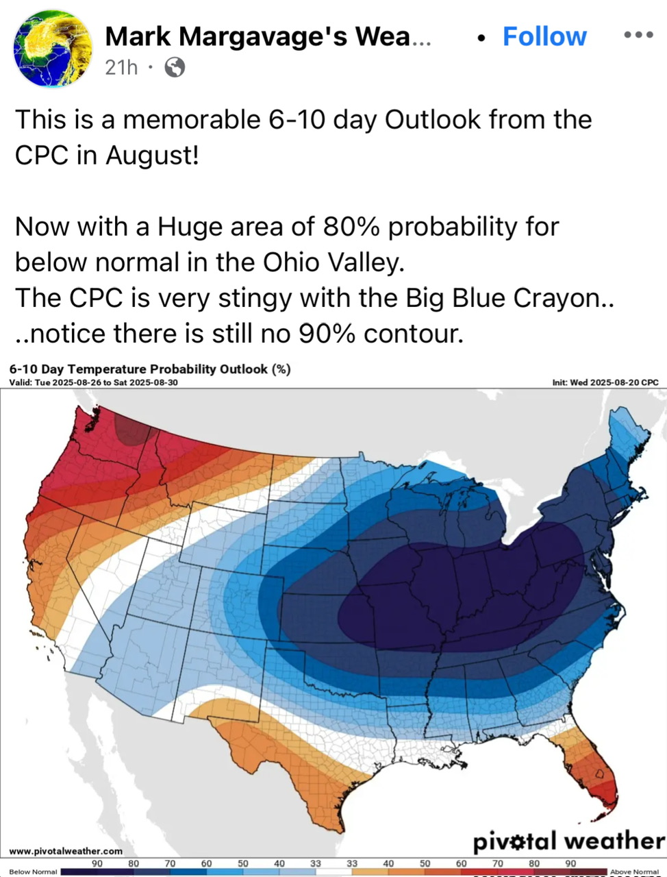
Not deep summer, but it is deep blue.
-
1.48” is the total here.
-

Mountain West Discussion
mayjawintastawm replied to mayjawintastawm's topic in Central/Western States
Will be interesting to see what happens with this pattern change. Over the last 60 days we've had 0.34" of rain. Ground moisture in non-irrigated spots is nonexistent. 40+ year old trees in the neighborhood are very stressed and some are dying.