All Activity
- Past hour
-
.thumb.jpeg.f5c6ba9d911ec96b3b124f8606aee58e.jpeg)
Major Hurricane Melissa - 892mb - 185mph Jamaica landfall
TJW014 replied to GaWx's topic in Tropical Headquarters
Still have Bermuda in the crosshairs. Could be a nasty storm for Nova Scotia & Newfoundland too. -

Major Hurricane Melissa - 892mb - 185mph Jamaica landfall
Hotair replied to GaWx's topic in Tropical Headquarters
And add to the fact that this isn’t a large country with thousands of roofing companies willing to travel to a disaster area. The workforce there is limited as are the tools (cranes, materials, etc). Many of those places will not be rebuilt for at least 3 years or longer. Now also consider that the percentage of homes covered by insurance in Jamaica is roughly under 5%. -

Central PA Fall Discussions and Obs
Jns2183 replied to ChescoWx's topic in Upstate New York/Pennsylvania
@Voyager this is your storm. Forecast close to 3" up that way. If only this were white. Sent from my SM-G970U1 using Tapatalk -

Major Hurricane Melissa - 892mb - 185mph Jamaica landfall
GaWx replied to GaWx's topic in Tropical Headquarters
BULLETIN Hurricane Melissa Advisory Number 34 NWS National Hurricane Center Miami FL AL132025 500 PM EDT Wed Oct 29 2025 ...MELISSA STARTING TO ACCELERATE NORTHEASTWARD OVER THE BAHAMAS... ...DAMAGING WINDS, FLOODING RAINS, AND A DANGEROUS STORM SURGE CONTINUING IN THE BAHAMAS THROUGH TONIGHT... SUMMARY OF 500 PM EDT...2100 UTC...INFORMATION ---------------------------------------------- LOCATION...22.9N 74.8W ABOUT 80 MI...130 KM SE OF THE CENTRAL BAHAMAS ABOUT 890 MI...1435 KM SW OF BERMUDA MAXIMUM SUSTAINED WINDS...90 MPH...150 KM/H PRESENT MOVEMENT...NE OR 35 DEGREES AT 16 MPH...26 KM/H MINIMUM CENTRAL PRESSURE...974 MB...28.77 INCHES -
Major Hurricane Melissa - 892mb - 185mph Jamaica landfall
GaWx replied to GaWx's topic in Tropical Headquarters
Forecasting some strengthening during next 24 hours: FORECAST POSITIONS AND MAX WINDS INIT 29/2100Z 22.9N 74.8W 80 KT 90 MPH 12H 30/0600Z 25.1N 73.5W 85 KT 100 MPH 24H 30/1800Z 29.1N 70.3W 90 KT 105 MPH 36H 31/0600Z 34.4N 65.2W 85 KT 100 MPH 48H 31/1800Z 40.7N 58.7W 75 KT 85 MPH 60H 01/0600Z 46.6N 52.3W 60 KT 70 MPH...POST-TROP/EXTRATROP 72H 01/1800Z 52.0N 45.4W 55 KT 65 MPH...POST-TROP/EXTRATROP 96H 02/1800Z 56.0N 32.5W 45 KT 50 MPH...POST-TROP/EXTRATROP 120H 03/1800Z 57.0N 27.5W 40 KT 45 MPH...POST-TROP/EXTRATROP $$ Forecaster Papin -

Major Hurricane Melissa - 892mb - 185mph Jamaica landfall
Wannabehippie replied to GaWx's topic in Tropical Headquarters
Water vapor loop, shows dry air and shear to Melissa's west, which is also giving it the kick to move to the NE. Its forward speed is up to 16MPH. blob:https://www.tropicaltidbits.com/d28d79c9-b1dc-4880-a36a-8269bda320bd -

Major Hurricane Melissa - 892mb - 185mph Jamaica landfall
WolfStock1 replied to GaWx's topic in Tropical Headquarters
Reading up - it does seem like a vessel or two - including S.S. Phemius and the schooner Abundance - that got caught in it and I guess got accurate enough measurements. Poor sods. Though it seems like they had to do a lot of extrapolating to come up with the 78-hour number. -
Major Hurricane Melissa - 892mb - 185mph Jamaica landfall
Wannabehippie replied to GaWx's topic in Tropical Headquarters
Western semicircle not looking great. Lots of deep convection near the center of circulation. -

Correlation of extreme hurricanes, AGW, and solar cycles
Roger Smith replied to WolfStock1's topic in Climate Change
Well as you probably know there are not often tropical storms in the South Atlantic Ocean, I believe there have only been two in modern times, and that is probably down to the water temperatures rarely exceeding 25 C there, as well as the size of the basin (but it's larger than the Arabian Sea which manages a few). The weather in the glacial maximum must have been quite extraordinary in general, maybe there were a few hurricanes but confined to the tropical latitudes. -

Major Hurricane Melissa - 892mb - 185mph Jamaica landfall
WxWatcher007 replied to GaWx's topic in Tropical Headquarters
That’s incredible. It’ll take a long time to recover. -
For fucks sake
-
Unless it snows at night, then the delicate children will be safely indoors exposed to 2000 lumens
-

Major Hurricane Melissa - 892mb - 185mph Jamaica landfall
gallopinggertie replied to GaWx's topic in Tropical Headquarters
Jesus…that footage is jaw dropping. Thank god Melissa didn’t hit Kingston, of course that’s small consolation for people living where it did hit. -
I met Pierre a few times at various concerts back in the 80’s. Class act, always made time for the fans.
-
I have been squirrel hunting for decades. Introduced by my dad. They are a gourmets delight prepared properly. Population varies from year to year based largely on last years hard mast crop. More mast last year, more squirrels this year.
-

Major Hurricane Melissa - 892mb - 185mph Jamaica landfall
AdamHLG replied to GaWx's topic in Tropical Headquarters
wow. -
-

Spooky Season (October Disco Thread)
Damage In Tolland replied to Prismshine Productions's topic in New England
Every bag of candy blown down The strongest winds occur Halloween night with gusts ranging between 25-35 mph (isolated to 40 mph) in the lower non-coastal elevations, around 35-45 mph (isolated to 50 mph) over the Worcester and Tolland Hills and the Berkshires, -
Central PA Fall Discussions and Obs
Jns2183 replied to ChescoWx's topic in Upstate New York/Pennsylvania
I have questions regarding this 3 hour flash flood guidance. The demarcation seems very close to the river basins. Are The drastic differences caused purely by recent rainfall amounts, or is the basin itself playing some role? Sent from my SM-G970U1 using Tapatalk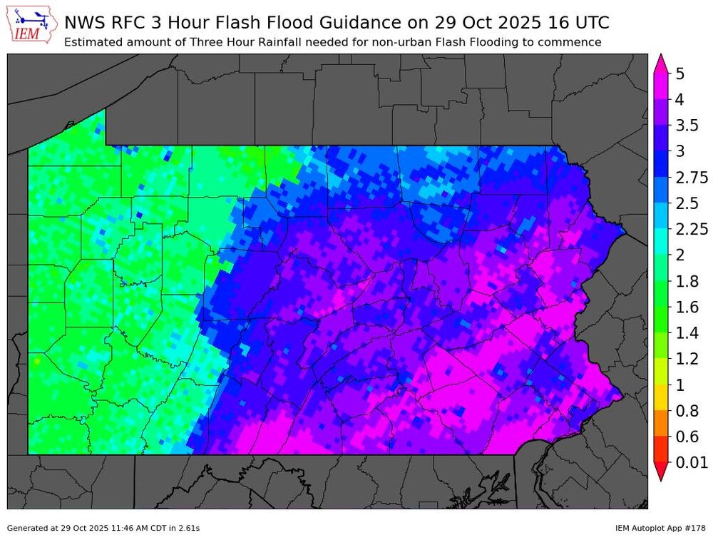
-
Major Hurricane Melissa - 892mb - 185mph Jamaica landfall
WxWatcher007 replied to GaWx's topic in Tropical Headquarters
Must have been some poor group of vessels in the path of it? -

Major Hurricane Melissa - 892mb - 185mph Jamaica landfall
olafminesaw replied to GaWx's topic in Tropical Headquarters
https://x.com/AndrewHolnessJM/status/1983616601464434863 First flyover shot I've seen. more tornado-like damage -
Major Hurricane Melissa - 892mb - 185mph Jamaica landfall
GaWx replied to GaWx's topic in Tropical Headquarters
From 4 hours ago, this stream from Jeff P. shows he and his friend driving around surveying the damage in Santa Cruz, Jamaica (and possibly also other nearby areas) with their main goal to see if they could help others: -
Some things never change!
-
They will be in the snow soon
-
Same here. Hope we didn’t jinx the rain.


