All Activity
- Past hour
-

December 2025 Short/Medium Range Forecast Thread
Carvers Gap replied to John1122's topic in Tennessee Valley
Haha. I was teaching 3rd grad that year. We ran out of snow days in Knox Co...like ran waaaay out of snow days. -

December 2025 regional war/obs/disco thread
weatherwiz replied to Torch Tiger's topic in New England
Yeah something is definitely up with how he's pulling the data or processing it. -

December 2025 Short/Medium Range Forecast Thread
*Flash* replied to John1122's topic in Tennessee Valley
I remember this storm. I was in 3rd grade. About 6-8" in Brentwood but the wind was howling which led to snow drifts up to my waistline in places! - Yesterday
-
December 2025 regional war/obs/disco thread
weatherwiz replied to Torch Tiger's topic in New England
For a second I thought we were looking at a tropical system somewhere -

December 2025 Short/Medium Range Forecast Thread
John1122 replied to John1122's topic in Tennessee Valley
That was one of the most severe winter events for the entire Tennessee Valley, ever. Huge ice storm, snow close to the blizzard of 93 levels, and cold close to 1985 levels. -
Nice 50 mile ride from the house today, trails were actually pretty decent, another 6 inches and they would have been perfect, oh well, I'd be surprised we had any snow Saturday morning, the bullseye is right over our heads ..

-

December 2025 regional war/obs/disco thread
moneypitmike replied to Torch Tiger's topic in New England
95 mph max. -
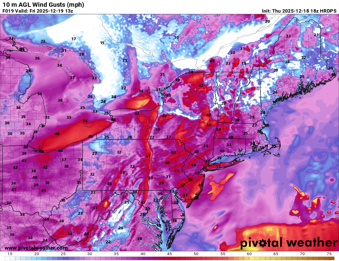
Wtf is Maue doing with that product? Pivotal has the actual model derived 10m gusts and it’s nothing close to that at that time.

-

December 2025 regional war/obs/disco thread
WxWatcher007 replied to Torch Tiger's topic in New England
All I care about is whatever happens between tomorrow’s cutter and 11:59:59pm on 12/25. After that, I’ll look at the longer range. -

December 2025 regional war/obs/disco thread
Damage In Tolland replied to Torch Tiger's topic in New England
Probs not far off -

December 2025 regional war/obs/disco thread
Baroclinic Zone replied to Torch Tiger's topic in New England
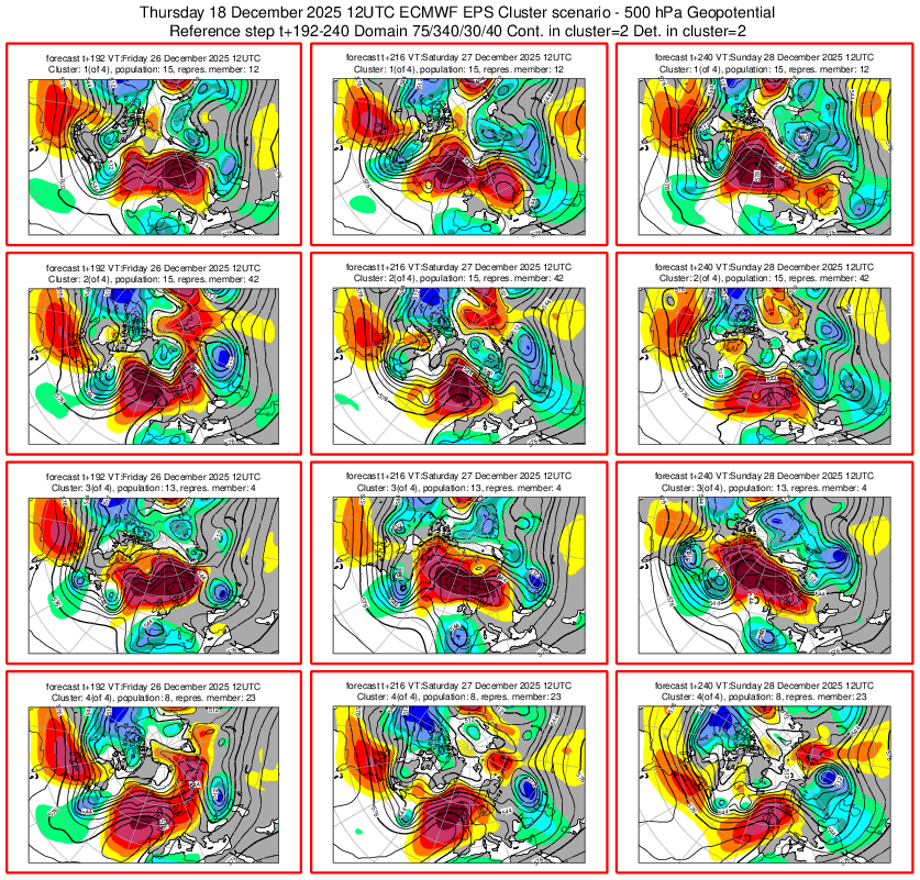
From what I’ve been seeing, the upcoming pattern post Christmas looks to be one of the most effed up convoluted patterns I can recall. We have a southeast ridge from Hell that looks to be established by the storm pattern shifting to our north. I’m also seeing storms that come out of the southwest with an injection of energy out westerlies coming around the south side of the se ridge. Wtf… good luck figuring out any consistent storm pattern. i still see a shot at a white Christmas with that storm popping up on the 23-25th. C/NNE have a shot at some wintry precip later this weekend. -
That’s not really what I said. I meant that they are more conservative than the typical weenie gust maps. They are still often a little too high…just not as bad.
-
Widespread 90mph near ALB. lol
-
DVN just issued the lamest winter storm warning in history. Talk about setting the bar low. Brief snow squalls with most areas seeing a DAB. Might as well just go all in and go with a blizzard warning, or hurricane warning.
-
Not sure why. I haven’t explored it deeply enough to find the reason. Maybe papers have been written on this already, but most are focused on El Ninos rather than La Ninas.
-
Doubt anyone anywhere sees much of any NAO blocking, unless an actual Scandinavian block happens first. The open ridges rolling over won't work for anyone. Including Europe. Models and ensembles still all over the place with that too. And that's something starting towards day 7 at this point. Need it to happen...
-
Clowns gonna clown
-
December 2025 regional war/obs/disco thread
weatherwiz replied to Torch Tiger's topic in New England
what in the sam hell. What boundary layer physics/equations are used by the HRDPS? That looks like its mixing down 100% of 925mb lmao. Does it think 10m is 925mb -
Looks like nasty squall line moving through during the morning rush tomorrow? Could be miserable. .
-
December 2025 regional war/obs/disco thread
Damage In Tolland replied to Torch Tiger's topic in New England
You let him sway your ideas and forecasts way too much . -

December 2025 Short/Medium Range Forecast Thread
Golf757075 replied to John1122's topic in Tennessee Valley
Then feb 1-2 1996 was a heck of a winter storm in my area. Very cold after that -

Central PA Winter 25/26 Discussion and Obs
canderson replied to MAG5035's topic in Upstate New York/Pennsylvania
My guess for peak gust at MDT tomorrow late afternoon: 57 mph -

December 2025 Short/Medium Range Forecast Thread
Holston_River_Rambler replied to John1122's topic in Tennessee Valley
I was trying to pull the radar imagery from IEM as gif, but the file won't process. Here's a link if anyone wants to check it out: https://mesonet.agron.iastate.edu/current/mcview.phtml?prod=usrad&java=script&mode=archive&frames=400&interval=60&year=1996&month=12&day=25&hour=0&minute=0 I think most folks who were alive at that time in upper east TN and SW VA know where the pattern ends up about Jan 7 - 8, 1996. -
Will this age like wine or milk? https://x.com/capitalweather/status/2001702501557374997?s=46
-
We had blowing fog here this morning. Don't think I've ever seen that before. There were waves of dense fog whipping horizontally with the gusty south winds over the remaining snow cover. Thought it was blowing snow at first until I realized what it was. All the snow is gone here now, other than piles. Rain mixed with wet snow right at the end. Picked up 0.19" of rain.