All Activity
- Past hour
-
Finally flipped back to snow here in the last 15 min
-
SN, 23/22°F, Additional 1.7", Now up to 6.5" total
-

Central PA Fall Discussions and Obs
Blizzard of 93 replied to ChescoWx's topic in Upstate New York/Pennsylvania
Look again… it’s predominantly snow or snow/mix until a little after 10 am… -

Central PA Fall Discussions and Obs
Jns2183 replied to ChescoWx's topic in Upstate New York/Pennsylvania
This says freezing rain for most of the storm Sent from my SM-S731U using Tapatalk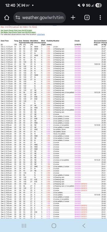
-
Central PA Fall Discussions and Obs
Blizzard of 93 replied to ChescoWx's topic in Upstate New York/Pennsylvania
Soon my friend, hopefully you & the Lanco crew cash in on the next one! The pattern looks potentially active through the next week, so hopefully it won’t be long until we are back tracking a specific chance. -
-

Central PA Fall Discussions and Obs
mahantango#1 replied to ChescoWx's topic in Upstate New York/Pennsylvania
JB said he expects that wave Friday night to come further north then what is forecasted now. But he didn't say how far north he expects to go. -
Central PA Fall Discussions and Obs
Blizzard of 93 replied to ChescoWx's topic in Upstate New York/Pennsylvania
“MM” at the 5 pm daily climate report. We will need to wait until the overnight climate summary. Based on the the observations, MDT stayed mostly snow or snow/sleet mix until a little after 10 am. I think your call of 2.5 has a chance to be right! -
Shocking because that usually works out (eyeroll)
-

December 2025 regional war/obs/disco thread
RUNNAWAYICEBERG replied to Torch Tiger's topic in New England
Not really. 4 years running of good tracks without a good airmass to tap into. Cold first then track. -

Fall/Winter Banter - Football, Basketball, Snowball?
Carvers Gap replied to John1122's topic in Tennessee Valley
@John1122, these last two basketball games and football game....like watching it snow in New Orleans, man. -
I'm actually not quite sure what goes wrong as I agree that on paper that what happens out west and to the north looks better with less push/suppression of the NS. My best guess is something happens either internally with the shortwave or the interaction between it and the low of Mexico causes its energy to become more stretched and further eastward based. Looking at it more the only real difference seems to be that the shortwave remains a bit more connected to the low of Mexico and there are slightly stronger H5 winds which as @CAPE pointed out hurts us by stretching out the vort. 0z wind map 18z wind map
-
.thumb.png.a8b917227b69a76da2cbc94017909de9.png)
-
3k NAM looked good at the end of its run.
-
Hi Res Nam is a little more interesting and colder
-
NAM still not showing much
-

Central PA Fall Discussions and Obs
Itstrainingtime replied to ChescoWx's topic in Upstate New York/Pennsylvania
I wish I could have shoveled. -
Here’s one I like (sadly it only goes up to 2013) http://www.raymondcmartinjr.com/weather/1996/Weather.html Gives me a nice trip down memory lane having lived through many of these storms. There are many maps at all levels of the atmosphere that shows the evolution of each storm. You’ll notice that the most powerful winter storms have a dual jet structure, where the low develops under the overlapping of both the left exit of one jet streak and the right rear entrance of another jet streak. Like double jeopardy. Rare, but truly amazing when it happens, and thats why they get so powerful. Look at the blizzard of 1996, perfect textbook example.
-
I’d be surprised if there was any significant warmup in the east given the MJO wave strength. We’ve seen before beyond D8-10 ensembles often can show a pattern that doesn’t really resemble what the expected MJO phase will be and then once you get closer it does. We’ve seen many maps like the above at day 15 when we have a strong wave in 3 or 4 and we know it’s going to be wrong
-
Strung out mess.
-

The Return of the 12/5 Snowstorm
NorthArlington101 replied to SnowenOutThere's topic in Mid Atlantic
Not as big a fan at 60 but thought things were headed north toggling back and forth the precip down in south. Mayhaps not Nope thru 69 -
Meh....so far
-
We probably picked up another .25" since I went out to clear snow an hour ago. Not a pellet of sleet today that I saw.
-
The snow pattern, the 'smiley face', ID/MT to NM/CO to Ozarks to interior New England I mentioned in October is showing up. It's a good pattern, most of the US will get a lot of snow this year, but probably not where 95% of you live. You'll see everything shift south 200-300 miles during the peak cold waves, but it won't stay that far south for periods long enough for major snows to the south of the main smiley face.
-

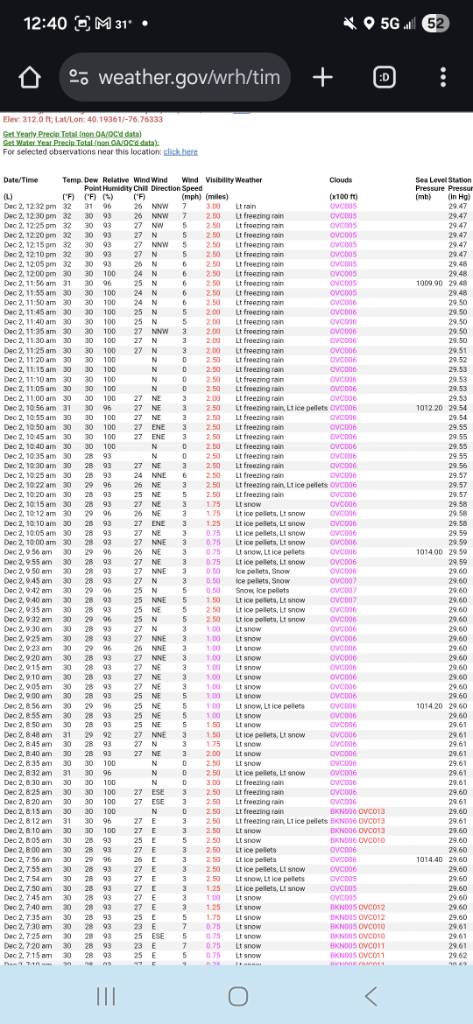
Central PA Fall Discussions and Obs
canderson replied to ChescoWx's topic in Upstate New York/Pennsylvania
Has anyone seen how much mdt reported?


.png.df03f219280a639d476d30e8f1f09dd0.png)


.thumb.png.4150b06c63a21f61052e47a612bf1818.png)
