All Activity
- Past hour
-
I dunno. I’m not feeling a storm named “Humberto” is going to break our cane futility streak. Not ominous sounding enough
-
BULLETIN Hurricane Gabrielle Special Advisory Number 22 NWS National Hurricane Center Miami FL AL072025 900 AM AST Mon Sep 22 2025 ...GABRIELLE RAPIDLY INTENSIFIES INTO A MAJOR HURRICANE SOUTHEAST OF BERMUDA... SUMMARY OF 900 AM AST...1300 UTC...INFORMATION ---------------------------------------------- LOCATION...30.6N 62.2W ABOUT 195 MI...310 KM SE OF BERMUDA MAXIMUM SUSTAINED WINDS...120 MPH...195 KM/H PRESENT MOVEMENT...N OR 10 DEGREES AT 10 MPH...17 KM/H MINIMUM CENTRAL PRESSURE...957 MB...28.26 INCHES Hurricane Gabrielle Special Discussion Number 22 NWS National Hurricane Center Miami FL AL072025 900 AM AST Mon Sep 22 2025 Satellite images indicate that Gabrielle has rapidly intensified into a major hurricane with a well-defined eye. The current intensity is set to 105 kt, a blend of constrained Dvorak estimates of about 100 kt with higher Data-T values of 115 kt. Further intensification is expected today, and the intensity forecast is raised for the first 24 hours, then kept the same afterwards. Small changes were made to the wind radii to account for the stronger hurricane. No changes were required to the track forecast. FORECAST POSITIONS AND MAX WINDS INIT 22/1300Z 30.6N 62.2W 105 KT 120 MPH 12H 22/1800Z 31.3N 62.1W 115 KT 130 MPH 24H 23/0600Z 32.9N 60.5W 110 KT 125 MPH 36H 23/1800Z 34.4N 57.4W 95 KT 110 MPH 48H 24/0600Z 35.4N 53.1W 90 KT 105 MPH 60H 24/1800Z 36.0N 47.6W 80 KT 90 MPH 72H 25/0600Z 36.7N 41.5W 75 KT 85 MPH 96H 26/0600Z 40.7N 28.9W 70 KT 80 MPH 120H 27/0600Z 44.2N 19.9W 55 KT 65 MPH...POST-TROP/EXTRATROP $$ Forecaster Blake
-

September 2025 OBS-Discussion centered NYC subforum
IrishRob17 replied to wdrag's topic in New York City Metro
It is an interesting microclimate phenomenon for those that appreciate weather as a whole. The fake cold thing is a term made up by those who must rely on Canada for their cold and can't generate their own. Only got down to 46 this morning, the dews are up a bit and clouds moved in. -
Looks like a low level wedge of fog south and east of I-95.
-

September 2025 OBS-Discussion centered NYC subforum
lee59 replied to wdrag's topic in New York City Metro
50 degrees here this morning -
I see a slight south trend with 6z..though best is still north of me. Pike to SNH?
-
Dick Tolleris?
-
I would love to take a 6 mile night hike in wind driven rain this week. Sent from my SM-G970U1 using Tapatalk
-
We will see humidity levels creeping up over the next couple of days. Today will be dry with temperatures well into the 70's. We will again be in the upper 70's to near 80 degrees tomorrow especially across valley locales. Rain chances start to ramp up by tomorrow night and those rain chances will stay with us for the rest of the week and through next weekend. A blend of all models sees between 1.5 to 2.0 inches of needed rain by Sunday morning. Of course, just like we don't shovel model snow - we can't count on model rain to deliver.

-
In my experience watching a friend’s chickens, they are never easy. Tiny Velociraptors running around. Mr. J and I are trial running the new EV out to Rehoboth Beach for a small vacation this week. The weather looks to be a bit better than over here cloud wise. Plan on doing a lot of exploring.
-
(002).thumb.png.6e3d9d46bca5fe41aab7a74871dd8af8.png)
E PA/NJ/DE Autumn 2025 Obs/Discussion
ChescoWx replied to PhiEaglesfan712's topic in Philadelphia Region
We will see humidity levels creeping up over the next couple of days. Today will be dry with temperatures well into the 70's. We will again be in the upper 70's to near 80 degrees tomorrow especially across valley locales. Rain chances start to ramp up by tomorrow night and those rain chances will stay with us for the rest of the week and through next weekend. A blend of all models sees between 1.5 to 2.0 inches of needed rain by Sunday morning. Of course, just like we don't shovel model snow - we can't count on model rain to deliver.
-
So where is the Sun? It is almost as difficult to predict Sunshine nowadays, as it is to predict snowfall in winter. My forecast grid was for mostly sunny skies. Now I see clouds have moved in already after 1 hour of sunshine at sunrise.
-
And Gabrielle has taken off. RI and up to 120 mph
-
weekend of IPA's, slow start to the week
-

September 2025 OBS-Discussion centered NYC subforum
Sundog replied to wdrag's topic in New York City Metro
My thermometer is about 20 feet up and in Queens but it managed to drop to 53 degrees this morning. I'll take it, better than Anthony's 59 haha -
Beer?
-

September 2025 OBS-Discussion centered NYC subforum
bluewave replied to wdrag's topic in New York City Metro
The shallow nature is what makes it such an interesting phenomenon. I radiate much better here by a wooded area just north of the sound. You really notice the temperature falling pretty quickly when the sun goes down. My old area back on the South Shore didn't radiate very well. So I had to rely more on strong CAA and the winds staying strong for my colder mornings near the ocean and bays. -
It looks like clouds and rain for the next 6 months setting in early this year lol. It started in late June here. I'm going to enjoy today before my trails turn to mud and slimy leaves again. Hopefully everything stays NW of my area.
-
That looks pretty robust to me. If I'm seeing it right, it looks like 3-4 inches along and either side of the I-81 corridor. Although, I'll admit that perusing the globals, WPC is much more aggressive than the models are currently indicating.
-
September 2025 OBS-Discussion centered NYC subforum
Sundog replied to wdrag's topic in New York City Metro
I mean isn't all radiational cooling shallow? I always called it fake cold as a joke but boy would I love to have some of that fake cold in summer when those locations might cool into the 60s overnight while I continue to bake near 80. -
September 2025 OBS-Discussion centered NYC subforum
bluewave replied to wdrag's topic in New York City Metro
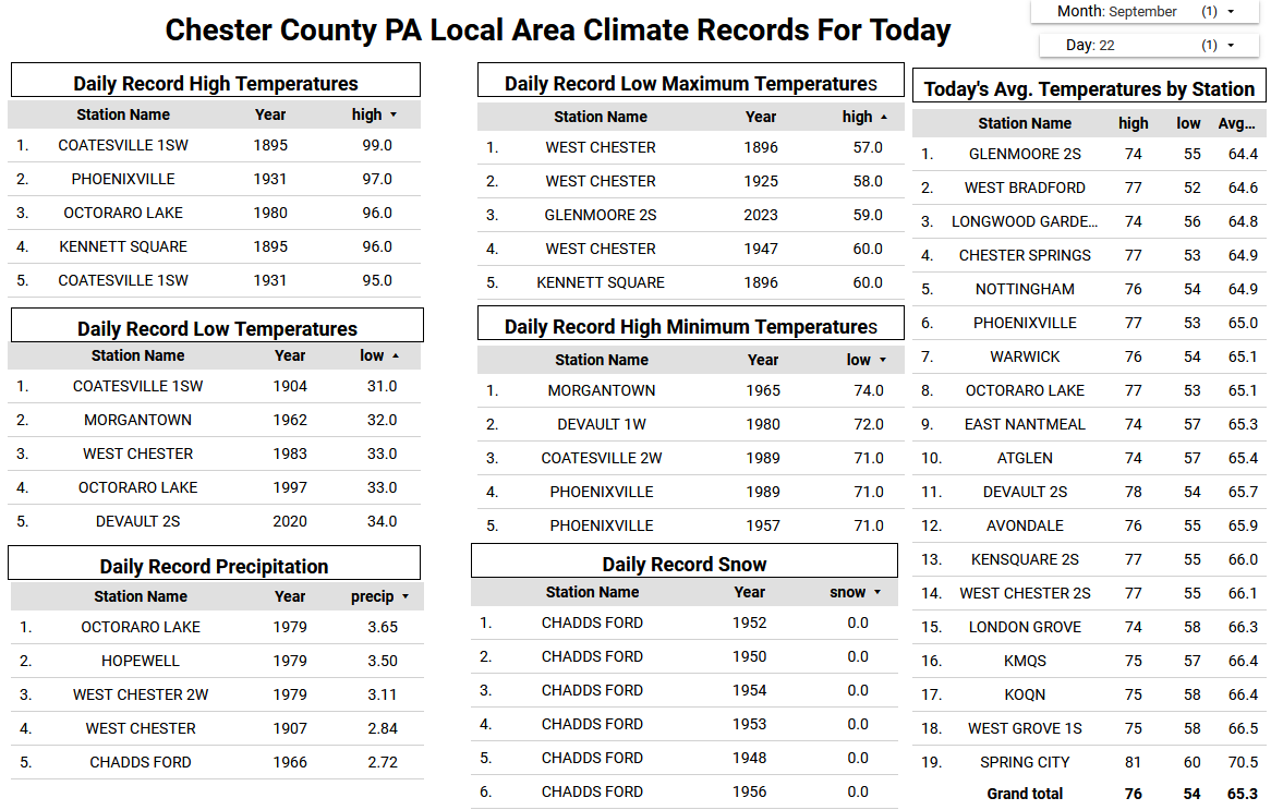
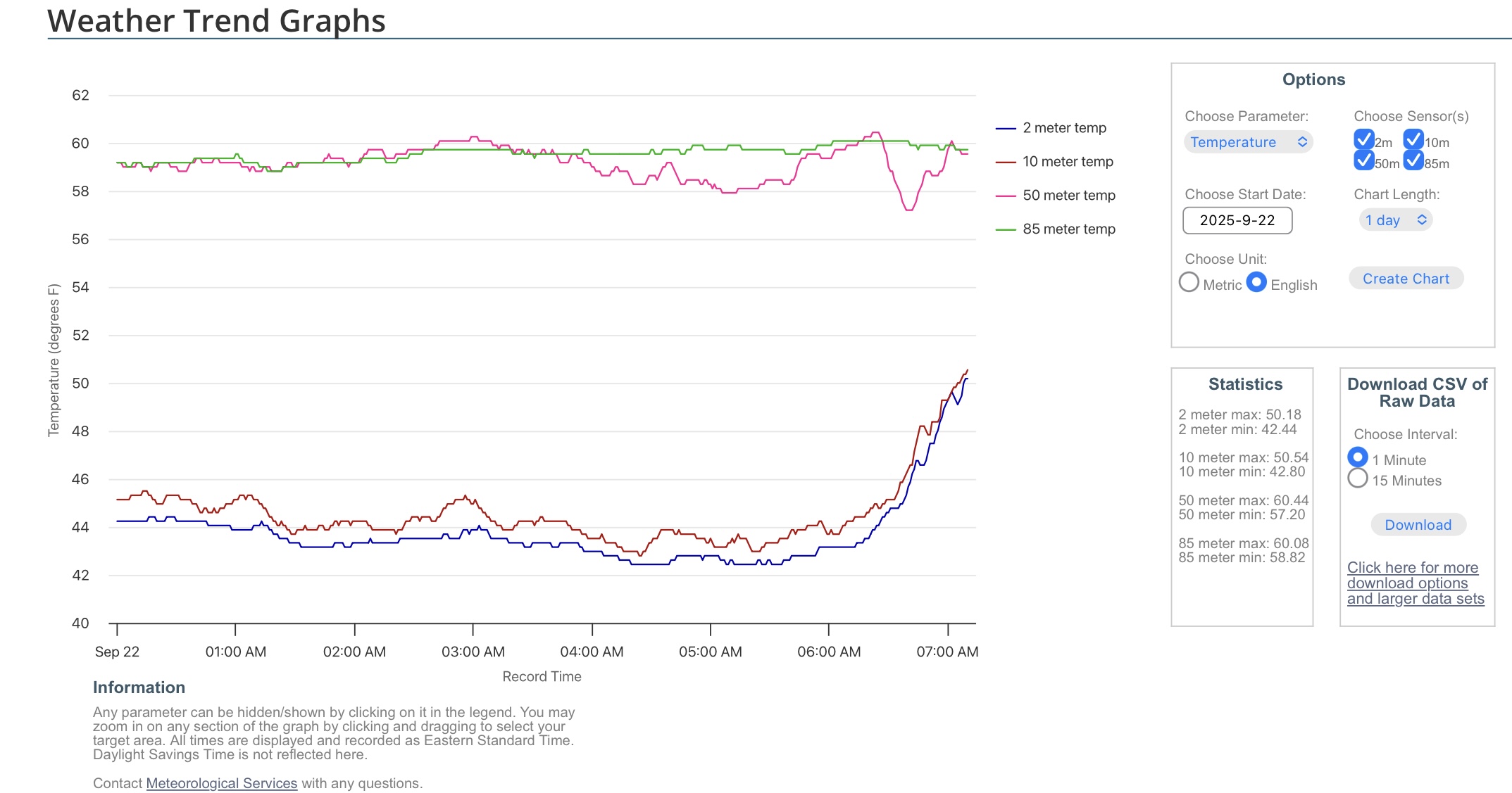
It’s pretty wild how shallow those radiational cooling inversions are. The low was only 57° at 50 meters up just above the treetops. That’s what the urban areas experienced this morning due to UHI around NYC.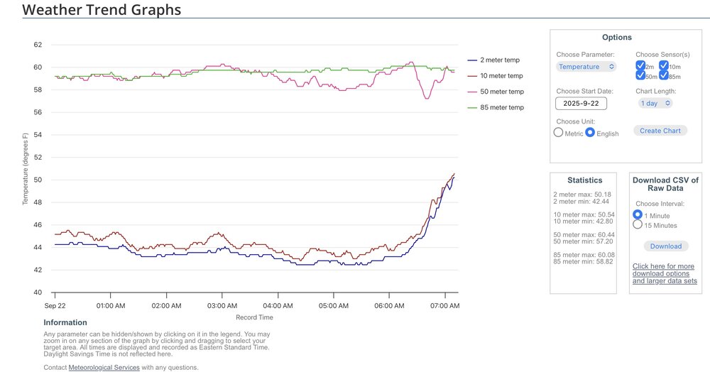
-
I'll be in Calvert Wed thru Sat staying with my dad and looking after pets while rest of family is out west for a wedding....including my nephew's SEVENTEEN chickens. It's easy when it's dry, but they told me it's a huge mess when it rains. Uh, I'm thinking I'm in trouble? Time to look for some mudder boots. QPF forecast looks juicy!
-
Bees are crazy this year! Both my daughter and I got stung though our clothing (she had a sweatshirt on!) earlier this month on a cool morning. I haven't had a bee sting in 35 years. Got me right in the gut too, super itchy for a couple days. I've also heard gasoline and a match will take care of them haha.
-

2025 Atlantic Hurricane Season
Michelle Davies replied to BarryStantonGBP's topic in Tropical Headquarters
Now that mandarin is a cherry and that lemon is a mandarin if you check the latest NHC page -
Here is the possible NE slobberer 2. East of the Leeward Islands: A tropical wave located about 400 miles east of the Leeward Islands continues to produce disorganized showers and thunderstorms. Environmental conditions appear marginally conducive for slow development over the next few days as the wave moves quickly westward to west-northwestward at 15 to 20 mph. By the latter part of this week, the system is expected to slow down and turn more northwestward, and a tropical depression could form late this week when the system is over the southwestern Atlantic Ocean or near the Bahamas. Regardless of development, gusty winds and showers are expected to affect portions of the Leeward Islands late tonight and Tuesday. * Formation chance through 48 hours...low...10 percent. * Formation chance through 7 days...medium...40 percent.