All Activity
- Past hour
-
@Gawx
-
 You sound like bizarro nycwinter
 -
 We got an early hint how cold the 1976-1977 winter was going to be with the record cold outbreak at the end of August 1976. Data for August 31, 1976 through August 31, 1976 Click column heading to sort ascending, click again to sort descending. NY WALDEN 1 ESE COOP 37 NY PORT JERVIS COOP 38 CT DANBURY COOP 38 NJ CANOE BROOK COOP 39 NY CARMEL COOP 39 CT WESTBROOK COOP 39 CT MOUNT CARMEL COOP 39 CT STAMFORD 5 N COOP 40 NY SCARSDALE COOP 40 CT MIDDLETOWN 4 W COOP 40 NJ CHARLOTTEBURG RESERVOIR COOP 40 NJ PLAINFIELD COOP 41 CT NORWALK GAS PLANT COOP 41 NJ ESSEX FELLS SERVICE BLDG COOP 42 NY YORKTOWN HEIGHTS 1W COOP 42 NY WESTCHESTER CO AP WBAN 42 NY SUFFERN COOP 42 NY WEST POINT COOP 42 NJ TETERBORO AIRPORT WBAN 43 NY BEDFORD HILLS COOP 43 CT NEW HAVEN TWEED AP WBAN 43 CT GROTON COOP 43 NJ LITTLE FALLS COOP 44 NY MIDDLETOWN 2 NW COOP 44 NY PATCHOGUE 2 N COOP 45 NY NEW YORK BOTANICAL GARDEN COOP 45 CT NORWICH PUBLIC UTILITY PLANT COOP 45 NY NY WESTERLEIGH STAT IS COOP 46 NY MINEOLA COOP 46 NY DOBBS FERRY-ARDSLEY COOP 46 NY BRIDGEHAMPTON COOP 46 CT NEW HAVEN COOP 47 NY SETAUKET STRONG COOP 47 NJ NEWARK LIBERTY INTL AP WBAN 48 NJ MIDLAND PARK COOP 48 NJ JERSEY CITY COOP 50 NY NY CITY CENTRAL PARK WBAN 50 CT IGOR I SIKORSKY MEMORIAL AIRPORT WBAN 50 NY GREENPORT POWER HOUSE COOP 50 NY LAGUARDIA AIRPORT WBAN 52 NY JFK INTERNATIONAL AIRPORT WBAN 52 NY ISLIP-LI MACARTHUR AP WBAN 52 NY MONTAUK COOP 52 NY NEW YORK AVE V BROOKLYN COOP 53 NY NEW YORK LAUREL HILL COOP 53 NY RIVERHEAD RESEARCH FARM COOP 54 Data for August 31, 1976 through August 31, 1976 Click column heading to sort ascending, click again to sort descending. PA TOBYHANNA POCONO MOUNTAIN ARPT WBAN 34 PA BELTZVILLE DAM COOP 35 NJ INDIAN MILLS 2 W COOP 36 NJ NEWTON COOP 36 PA EAST STROUDSBURG COOP 37 NJ SUSSEX 1 NW COOP 37 NJ MORRIS PLAINS 1 W COOP 37 NJ FLEMINGTON 5 NNW COOP 38 NJ SOMERVILLE 4 NW COOP 38 PA PERKASIE COOP 39 PA PALMERTON COOP 39 NJ CHATSWORTH COOP 39 PA GEORGE SCHOOL COOP 39 MD CENTREVILLE COOP 40 NJ BELLEPLAIN STA FOREST COOP 40 NJ ATLANTIC CITY INTL AP WBAN 40 NJ PEMBERTON COOP 40 NJ ESTELL MANOR COOP 40 NJ TOMS RIVER COOP 40 PA PHOENIXVILLE 1 E COOP 41 NJ HIGHTSTOWN 2 W COOP 41 NJ LAMBERTVILLE COOP 41 NJ FREEHOLD-MARLBORO COOP 41 NJ BOONTON 1 SE COOP 41 DE GEORGETOWN 5 SW COOP 42 MD MILLINGTON 1 SE COOP 42 PA WEST CHESTER 2 NW COOP 42 PA GRATERFORD 1 E COOP 42 PA READING 4 NNW COOP 42 NJ WOODSTOWN PITTSGROV 4E COOP 42 NJ HAMMONTON 1 NE COOP 42 NJ BELVIDERE COOP 42 NJ TUCKERTON 2 NE COOP 42 NJ LAKEHURST NAS WBAN 42 DE MIDDLETOWN 3 E COOP 43 PA COATESVILLE 1 SW COOP 43 PA MORGANTOWN COOP 43 PA ALLENTOWN LEHIGH VALLEY INTERNATIONAL AIRPORT WBAN 43 NJ CHERRY HILL COOP 43 NJ LONG BRANCH-OAKHURST COOP 43 NJ NEW BRUNSWICK 3 SE COOP 43 DE MILFORD 2 SE COOP 44 NJ SEABROOK FARMS COOP 44 NJ WEST WHARTON COOP 44 MD EASTON COOP 45 DE BRIDGEVILLE 1 NW COOP 45 MD DENTON 2 E COOP 45 DE NEWARK AG FARM COOP 45 PA WEST GROVE 1 SE COOP 45 DE WILMINGTON PORTER RES COOP 46 NJ SHILOH COOP 46 NJ MILLVILLE MUNICIPAL AIRPORT WBAN 46 PA NORTHEAST PHILADELPHIA AIRPORT WBAN 46 NJ GLASSBORO 2 NE COOP 47 PA WILLOW GROVE NAS WBAN 47 MD CHESTERTOWN COOP 48 NJ AUDUBON COOP 48 NJ TRENTON WBAN 48 MD ROYAL OAK 2 SSW COOP 49 DE DOVER COOP 49 MD PRESTON 1 S COOP 49 DE WILMINGTON AIRPORT WBAN 50 PA DEVAULT 1 W COOP 50 PA NORRISTOWN COOP 50 NJ CAPE MAY 2 NW COOP 50 NJ SPLIT ROCK POND COOP 50 PA PHILADELPHIA INTL AP WBAN 51 DE LEWES COOP 53 PA DREXEL UNIV COOP 53 PA MARCUS HOOK COOP 54 PA PHILADELPHIA 23D & MARKET COOP 54 PA PHILADELPHIA WBAN 56 PA PHILADELPHIA WSFO COOP 56
 -
The standards or 30 year climate normals originated back in a stable climate when there weren’t significant temperature rises with every new 10 year update. This is why your area had the warmest summer on record back in 2020 at 77.9° and the departure was only +2.9° using 1991-2020 climate normals. Under the 1951-1980 climate normals it would have been a +4.3 summer. It’s why NOAA is exploring using alternatives to the climate normals. Many organizations just set the climate normals to an earlier period before the climate began to rapidly warm so the departures more closely resemble the actual temperatures. https://yaleclimateconnections.org/2021/02/updated-yardstick-begs-question-whats-normal-in-a-changing-climate/ Time Series Summary for Middletown-Harrisburg Area, PA (ThreadEx) Top 10 warmest summers using dense rank sorting for temperature Click column heading to sort ascending, click again to sort descending. 1 2020 77.9 0 2 1966 77.6 0 3 2016 77.3 0 4 2021 77.1 0 5 2024 76.9 0 6 2010 76.8 0 7 2022 76.7 0 - 1999 76.7 0 8 2019 76.5 0 - 2005 76.5 0 9 1991 76.4 0 10 1900 76.2 0
-

2025 Atlantic Hurricane Season
WxWatcher007 replied to BarryStantonGBP's topic in Tropical Headquarters
I don’t see anything possible other than homebrew/hybrid off the east coast in the next week or so. -
Had a heavy lake-effect rain shower move through late this morning. Was hoping for one rumble to make it a rare lake-effect thunderstorm but no such luck.
-
 Agreed. If you're not in the shade and there's 0 clouds anything above 70 or so feels quite hot
 - Today
-
 It was this morning...52 here. Felt chilly when I went out with the kids for first day of school pics at 7am...warming nicely though 77 here perfect day
 -
No. First, the 136 are readings from different locations and elevations than MDT with a period that includes very rural times. My family used to drive from MD to Wilkes-Barre every summer in the mid and late 1960's, driving through Harrisburg to get there, and it looks nothing like it did then. I can only imagine how much more rural it was before the 1960's. Second, my original post said MDT would likely end up slightly AN under the current climate period for June-August, and it will. I wasn't pushing any notions. Finally, using your argument, why not go back further, say hundreds of thousands of years, that clearly show we were much warmer? Current climate number, imho, are a better way to fairly represent above and below normal temps, all things considered, and apparently the NWS has felt the same way long before issues of warming were ever discussed.
-
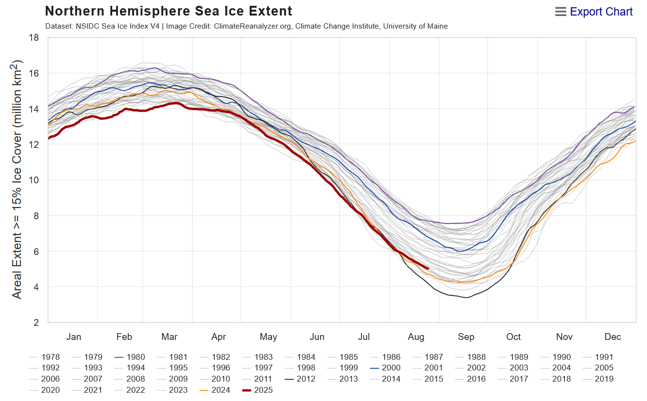
snow melt season is getting later and later in the arctic... might be late september until ice loss is at a end..
-
 i remember in the 1980's when a cold front came through temp fell into the 50's one afternoon in nyc in september that would be impossible today..
 -
Oh, ha... well, in that case - any given location could get lucky with a training axis. This does look a bit like it could be a slow evolving scenario so convection might orient into favored bands, along which there can be decent totals. In between? not so much.
-
 It's 80/52 and sunny here. I took my jacket since it was so brisk.
 -

2025 Lawns & Gardens Thread. Making Lawns Great Again
dryslot replied to Damage In Tolland's topic in New England
It is a small young tree 2', It still has some cambium attached, I used some grafting tape and are supporting it with a dowel, I hate to cut it off as its the top of the tree, But if it doesn't take i will have to prune it off, I'm finishing up a small greenhouse to winter them in as i have no room in the house and don't need my cats eating the leaves although those thorns are quite painful as i found out.................... -
Another chilly a.m. with Duluth 40 (t3rd), Hibbing 36 (4th), I-Falls 39 (t6th). Significantly cool air mass for this time of year to be sure. Scattered shwrs/stms cast for tomorrow, so hope to get under some of that. Other than that, pretty seasonable wx overall to end the month after the front blows thru as avg temps start their Fall slide. Upper 60's-low 70's with upper 40's-low 50's. Inland areas may get a little cooler with radiational cooling. A very nice Labor Day weekend on tap. Looks like my Holiday forecast will be pretty good.
-
 It’s not cool today lol
 -

2025 Lawns & Gardens Thread. Making Lawns Great Again
dendrite replied to Damage In Tolland's topic in New England
How large is the branch? Was it a complete break or is some cambium still attached? On bigger splits some people drill through each side and kinda clamp it together. Or you could use a couple ratchet straps and get it tight. If it’s a small tree, nevermind. lol -
Could certainly be some upslope enhancement up in NNE. Also wouldn't rule out the potential for a tornado or two within the valley.
-
I inspect our dams over here in Montgomery County. Generally, this region take good care of the water infrastructure.
-
Nammy actually slows the front a bit over the region as the ULL starts to stall north of ART.
-
Interesting shallowing of the ice loss ...relative to recency that is. Good sign for winter enthusiasts? - well, at least analytically for me I've come to find in the past that the rates of d(ice) and d(land-snow) in autumns appeared to be positively correlated to N/A mid latitude winters during ensuing cold season. We've still got about 2 weeks to go before climo bottoms out and we enter autumn so we'll see if this year can be another test for that.

-
Dendy soaker
-
Thanks Tip. i mean, I could really use the rain. Sitting at just over 1/2" here MTD. the summer fronts tend to split not long before they get here, so it is usually not very rainy. glad to hear that this is a frontal passage, not a synoptic rain event.
-
The 12Z Icon, which then has it become a TS, is implying an eventual though not immediate safe recurve from the US would later occur on that run fwiw. Other 12Z runs: -GFS still doesn’t have a TC from the far E MDR AEW. However, it does now have a weak reflection at the sfc as well as upper level vorticity clearly showing up now. So, this is a hint that the GFS may in runs soon start showing this as a closed sfc low. -CMC has nothing unlike prior runs -UKMET, Euro, and JMA still yet to be released Edit: Edit: -UKMET is 2nd run in a row without it -Euro: dropped it So, for now it’s just the Icon although JMA not yet out