All Activity
- Past hour
-

January 25/26 Jimbo Back Surgery Storm
Blacksburg Coach replied to Jimbo!'s topic in Southeastern States
I once had an engineering pal tell me "without enough time and money, you can do just about anything". Right now we are not putting any time or money into the sciences. -

January 25/26 Jimbo Back Surgery Storm
Brick Tamland replied to Jimbo!'s topic in Southeastern States
-
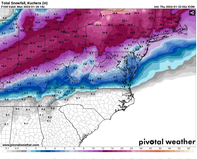
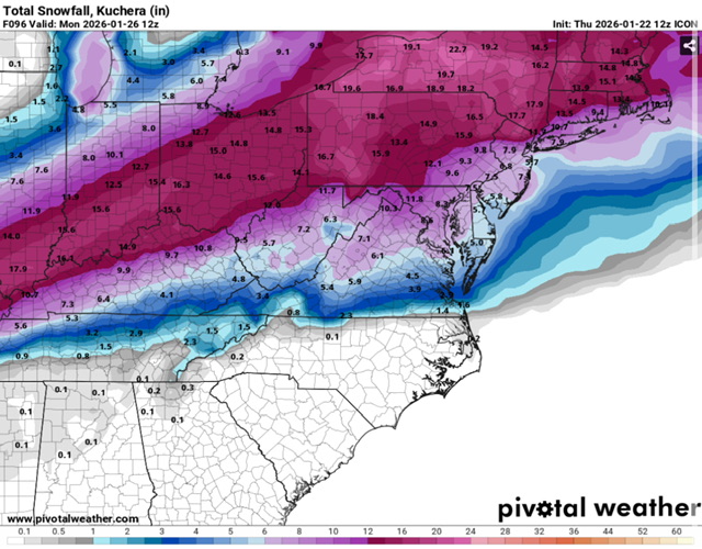
Here’s the 6z and 12z comparison
-

January 25/26 Jimbo Back Surgery Storm
NorthHillsWx replied to Jimbo!'s topic in Southeastern States
Updates after 24 hours: Triangle: TR of snow, only around 1” sleet, .25-.30” ZR (going with less QPF than we thought yesterday and warmer profiles) Triad- not much change but bringing IP down to 1-3” because less QPF Foothills- reducing SN to TR-1”, IP 2-4”, 0.10-0.30” ZR more south. Thinking more ZR due to warmer profiles. Still thinking 0.10-0.25” ZR Charlotte- TR SN, 1-2” IP, 0.25-0.30” ZR. Pretty much untouched but less QPF NC Coastal Plain- significantly less ice east of 95. Stripe of 0.25-0.5” between there and Raleigh. High end is lesser bc less QPF and warmer profiles Upstate- almost no changes. Maybe bring IP down to 1-3” because less QPF SC low country-Midlands-NC Sandhills- this is where biggest changes are. IP MAYBE up to 1/2” north. Tr-0.25” ZR for midlands but Sandhills could see up to 0.5” ZR. This area has bust potential to be much less because the entire area could switch to rain after way less QPF below freezing ATL- big changes here too. 0”-TR IP, up to 0.25” ZR mostly NE suburbs with less I’m town. Limited impacts compared to thoughts yesterday. NE GA north and east of ATL will be similar to my upstate prediction -

Possible Record Breaking Cold + Snow Sunday 1/25 - Tuesday 1/27
SACRUS replied to TriPol's topic in New York City Metro
ICON wrap around on Monday morning -

“Cory’s in LA! Let’s MECS!” Jan. 24-26 Disco
cleetussnow replied to TheSnowman's topic in New England
Be like
-

1/24-1/25 Major Winter Storm - S. IL, IN, MI and OH
Stevo6899 replied to A-L-E-K's topic in Lakes/Ohio Valley
Yea these scenarios always make me wonder if the low isn't that strong overall and the phasing is the only thing making this a storm. What's preventing the low from dropping below 1000 and kinda bombing/not transferring. Obviously beyond my meteorological knowledge. Cold high to the north shunting it? -

Possible Record Breaking Cold + Snow Sunday 1/25 - Tuesday 1/27
NEG NAO replied to TriPol's topic in New York City Metro
Maybe there is a cutoff time in the evening when the data has to be delivered to whoever inputs it into the models- I have no idea how that works do you? -

Pittsburgh/Western PA WINTER ‘25/‘26
TimB replied to Burghblizz's topic in Upstate New York/Pennsylvania
Icon held. -
Possible Record Breaking Cold + Snow Sunday 1/25 - Tuesday 1/27
SACRUS replied to TriPol's topic in New York City Metro
ICON 12Z -
Me too but in CT. It was absolutely crippling. Believe it was 98 when the pics coming out of Canada had major substations bent and twisted all over. It was incredible.
-
ICON was actually a tick SE and gave most areas (including NW areas) about 25% more snow.
-
I’ll tell everyone that I’m not paying attention but then watch every model run. It’s a sickness really
-
Icon was heading euro and gfs way. Onto the real models now
-

January 24-26: Miracle or Mirage JV/Banter Thread!
87storms replied to SnowenOutThere's topic in Mid Atlantic
Yea the changeover seems to get triggered by that spoke of Baja energy rotating closer by midday Sunday. Hope this doesn’t become a Feb 94. Unlikely, but it would really help to get a closed low below our latitude again at some point like most of the big storms do. -
Nam has lp cutting midle TN not seen that on any model
-
January 25/26 Jimbo Back Surgery Storm
Blacksburg Coach replied to Jimbo!'s topic in Southeastern States
I think it also forces the real guys to be more conservative in forecasting to avoid the alarmist reputation. -
Seems that the first couple pieces of guidance at 12z (NAM, RGEM,ICON) delay the phase out west compared to their previous runs. And before anyone says anything i know these are not even the B squad lol
-
Gut feeling is ICON ticks south…seems to be a bit more suppression in the northern stream edit….looks like it ended up not being a major difference sensibly
-
Yeah... the outcome is not much different on the ICON
-
ICON is 6-12", more NW, less SE. I'm going to take that and run,
-
Agree! I really want to be careful in how I say this...because I do not want to sound condescending. I do not know what has happened in the weather world. And I do not mean the meteorologist....I mean the models. The models just are not reliable anymore. The Science World for Weather...like US National Weather Service Greenville-Spartanburg SC need to figure this out. How can the models be this wrong. Now for the Forecasters via TV. They are just doing the best they can based on what the models are telling them. And I am positive that after a storm like Helene....they just want to take every potential threat seriously. The guys at GSP NWS are the best in the business. No one is immune to unpredictable weather. Truth is, only ONE knows...and that is our Creator! My fear is, people will draw cold to forecast and become that "yea right" person. And I get it. I guess I'm saying, show some grace to forecasters. Yes, there are some that get dramatic for hits, and will go all out and the worst/best case scenario. Learn who those people are. Otherwise, just be as prepared as you possibly can for weather related problems. As the case for this weekend, it appears to be a total "letdown" from the first expectations. But trust God! We all want what is best for each other. If it gets bad, check on your neighbors!
-
Possible Record Breaking Cold + Snow Sunday 1/25 - Tuesday 1/27
SACRUS replied to TriPol's topic in New York City Metro
-
Oh, interesting trend on the ICON popping into view. Check the low around Hudson Bay. Run to run it is impinging downstream on the NS energy that wants to phase. Could that help string out the energy perhaps and de-amp?
-
Yep in vermont I have seen ZR at 12F


