All Activity
- Past hour
-

New Years Day 2026 - 1st snows of the new year possible
Damage In Tolland replied to Baroclinic Zone's topic in New England
I remember models kept showing it and we never fully believed it. The radar had the snow falling over the valley but it all fell over the hills. Was fascinating event . It was torched away less than 2 days later . Here’s that radar https://imgur.com/a/E6cdjp4#w4DU9Zm -
Don’t know what the rest of winter holds, but this was a very solid December by our standards. Below to much below normal temps and normal to above normal snow for about everyone (sorry Winchester and Stephen’s City).
-
It’s always weeks away and it will stay there lol.
-

New Years Day 2026 - 1st snows of the new year possible
DavisStraight replied to Baroclinic Zone's topic in New England
He comes up with these memes super quick. -

New Years Day 2026 - 1st snows of the new year possible
The 4 Seasons replied to Baroclinic Zone's topic in New England
https://www.jdjweatherconsulting.com/mar-22-23-2019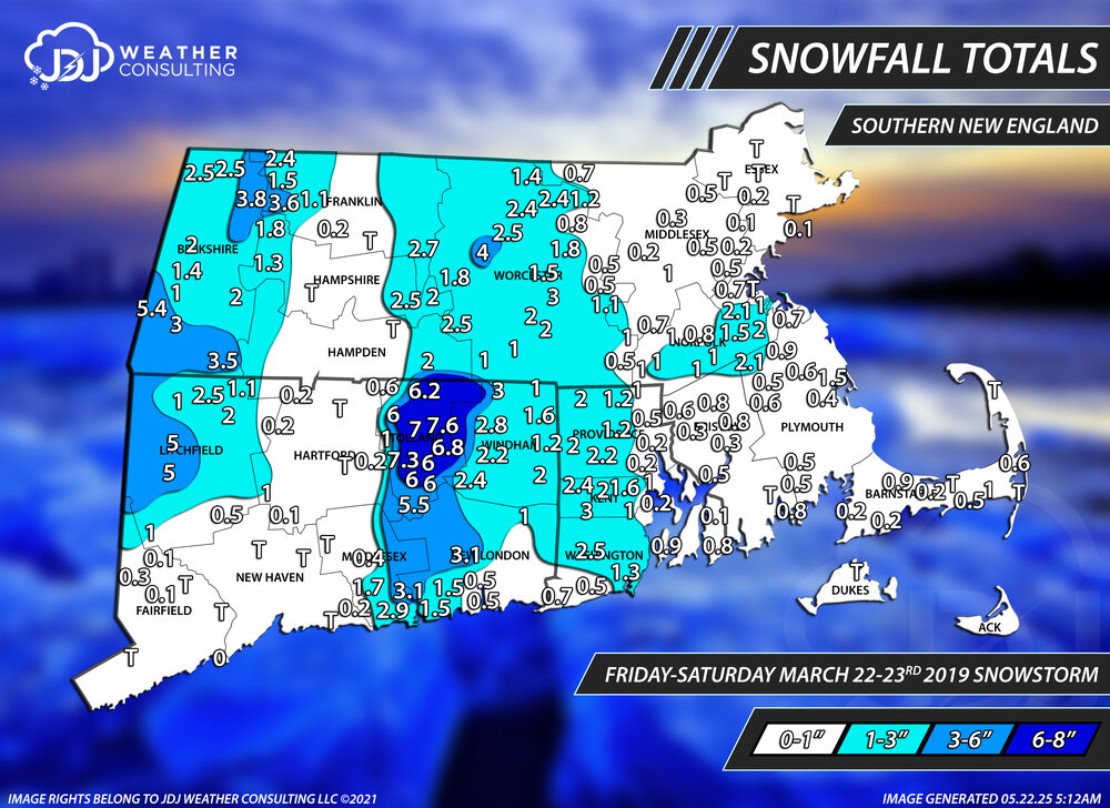
-

New Years Day 2026 - 1st snows of the new year possible
WinterWolf replied to Baroclinic Zone's topic in New England
Lmfao…. That’s crazy funny. -
New Years Day 2026 - 1st snows of the new year possible
WinterWolf replied to Baroclinic Zone's topic in New England
..that was good. -
New Years Day 2026 - 1st snows of the new year possible
Damage In Tolland replied to Baroclinic Zone's topic in New England
Not the same but it reminded me of this event . What a weenie event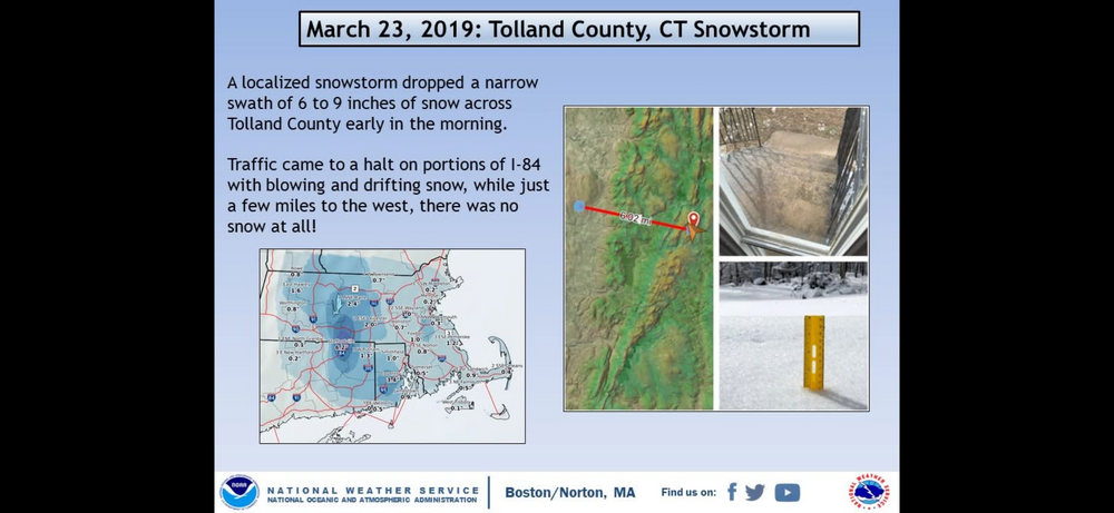
-
Completely overcast in DC (though NWS insists it's supposed to be "mostly sunny"). Haven't seen a single flake of snow, though.
-
New Years Day 2026 - 1st snows of the new year possible
The 4 Seasons replied to Baroclinic Zone's topic in New England
OKX followed suit no surprise for continuity amongst the CWAs -
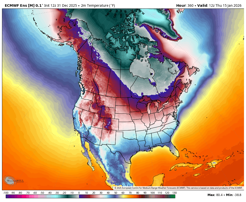
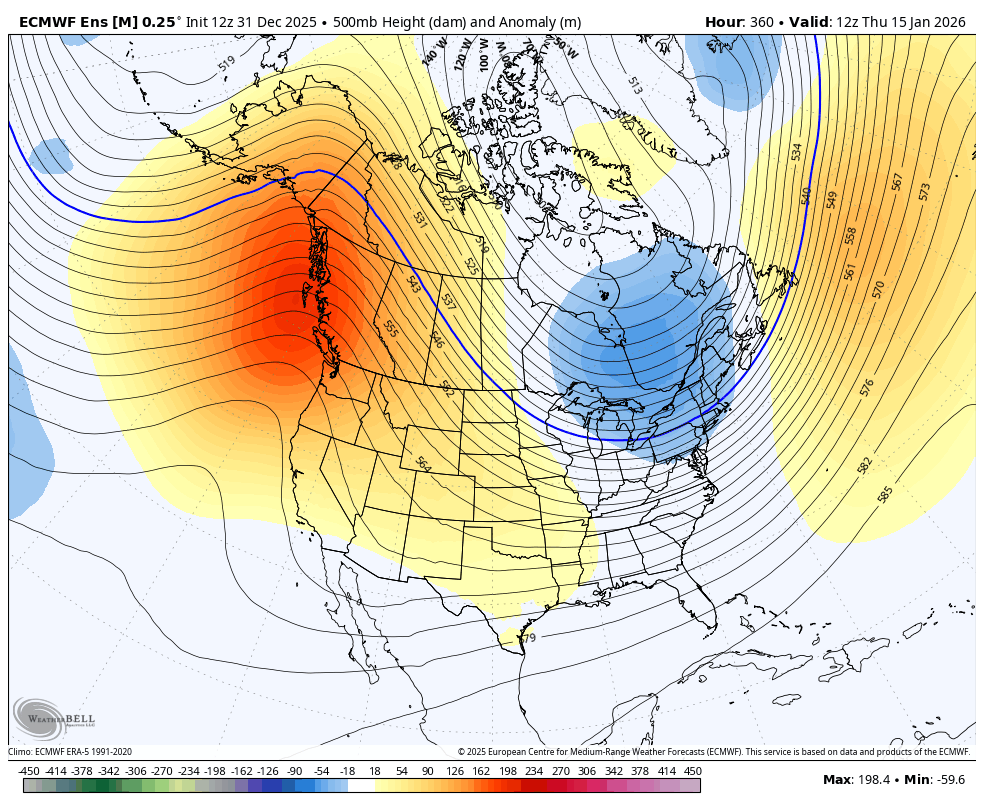
WB 12Z EPS ensemble at range is cold enough: question is will it delivery anything but the same old same old for the later half of the month.


-
Maybe we can flip back but it usually doesn’t work that way for us. All we want is one good snow. That’s not asking for much from us weenies.
-

January 2026 regional war/obs/disco thread
Typhoon Tip replied to Baroclinic Zone's topic in New England
You were NAO'ed Heh... 'not the first time anyone was, whence seemingly waiting on the commitment by the analyst, that's when NAO fails to show up. Intention? Charlie Browning - Personally I find the NAO to be the biggest most stochastic POS voodoo index that was ever defined. The problems in using it are textured and varied. Firstly, ( I'm not intending the lecture you; I'm just raging at the moment lol) is that it is actually created by the dispersion mechanics downstream off the Pacific -N/A wholesale wave signature. [ Enter pita flop computing power here ...] and viola! the NAO emerges in the guidance... Secondly, there are two behaviors, which is a major pain in the ass. The first is the obvious: blocking, identified by the geometry of the heights up there in the NAO geographic domain space. The other form is insidiously hidden - the hemispheric logistics around the region act as though that geometric identity must be there, when one is not very obviously defined... See, this is an indirect proof that the forcing actual coming from somewhere else. Whether heights bloom within that behavior or not, that's when the EOF calculations finally give negative numerical values. Anyway, so the NAO is so badly handled ...or, so much worse so than the other indexes, because it is at the flop end of the Pacific hose, where is also exaggerated by interaction across the N/A continent. -
That would make sense, that glacial ridge northwest of you (the Irish Hills) are probably a little snowier than Ann Arbor too for that reason.
-

E PA/NJ/DE Winter 2025-26 Obs/Discussion
RedSky replied to LVblizzard's topic in Philadelphia Region
Sleet crust in north facings a veritable winter wonderland -

New Years Day 2026 - 1st snows of the new year possible
dendrite replied to Baroclinic Zone's topic in New England
WWGW
-
Are you talking about the Irish Hills?
-
New Years Day 2026 - 1st snows of the new year possible
DavisStraight replied to Baroclinic Zone's topic in New England
That's what your girlfriend says. -
GEFS looks ugly through mid month, EPS is a bit better but doesn't bring much cold down until the very end of the run about 15 days from now. What a difference a couple of days make. Like I said previously, I would be happy with a 2 week at or below average period with an active storm track.
-
 DCA _ NYC _ BOS _ ORD _ ATL _ IAH _ DEN _ PHX _ SEA -1.5 -1.4 -1.2 -1.6 0.9 +1.0 +0.5 +1.6 +1.0
 -

January 2026 regional war/obs/disco thread
Chrisrotary12 replied to Baroclinic Zone's topic in New England
If it’s not going to snow… can it at least be warm? My gas bill would benefit. -

New Years Day 2026 - 1st snows of the new year possible
moneypitmike replied to Baroclinic Zone's topic in New England
GYX and BOX--possibly already posted.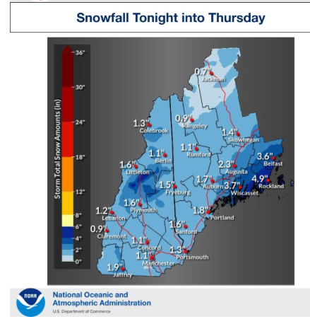
-

E PA/NJ/DE Winter 2025-26 Obs/Discussion
Ralph Wiggum replied to LVblizzard's topic in Philadelphia Region
Flurries here. We are a true snow town. Some squalls tomorrow as well. You guys keep looking towards mid January, I'm going to enjoy whats right in front of us. -
So awesome! Sounds like you all are having a great time! Keep the pics coming! It's likely the only snow I see this winter....
-

New Years Day 2026 - 1st snows of the new year possible
Bryan63 replied to Baroclinic Zone's topic in New England
Have to imagine the timing of it all on New Years Eve and people out driving impacts the language being used.