All Activity
- Past hour
-

Central PA Winter 25/26 Discussion and Obs
pawatch replied to MAG5035's topic in Upstate New York/Pennsylvania
Merry Christmas All! May the snow gods be with us this upcoming year! -
Imagine the chaotic forecast the NWS would have if they just used Modelology, and not Meteorology. Changing their forecast every couple hrs, when a new model run comes out. It would be ridiculous, and no one would pay them any mind.
-
 Even newer update
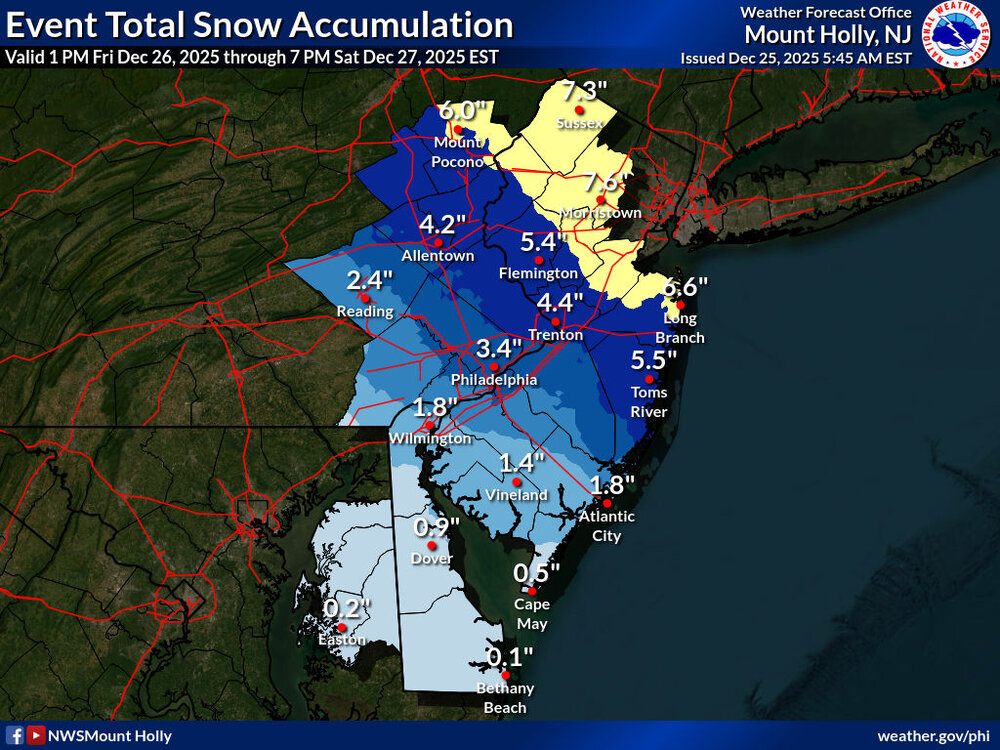
-
-

26th-27th event, coming at us like a wounded duck.
TauntonBlizzard2013 replied to Go Kart Mozart's topic in New England
Lasts nights moves didn’t continue at 6z. Congrats to CT, we’ll be hoping for some scraps. going to be another event where we probably end up with bare ground after -

Boxing Night Snow/Sleet/Ice Dec 26-27 Storm Thread/Obs.
dseagull replied to Mikeymac5306's topic in Philadelphia Region
They are broadcasting to an entire region of the country. They cannot sway back and forth. If the models continue to pull back for three consecutive runs, they will slowly reduce their forecasts. A bunch of weather enthusiasts call it "saving face," but it's actually been a standard for a long time. Public safety is their number one concern, so a bust isnt actually a bad outcome in terms of forecasting for a government agency. Agree though, this is trending wayyyyyy N and somewhat E. -

26th-27th event, coming at us like a wounded duck.
snowman19 replied to Go Kart Mozart's topic in New England
@CoastalWx I can’t believe there’s still people peddling 6-12 and 8-12 forecasts for the NYC metro area. They are going to bust hard. The QPF never supported those amounts, the ratios never supported it and now the new meso model runs (high res RGEM and 3K/12K NAM) are showing a very strong mid-level warm nose and turn it into a sleet-a-rama even well north and west of the city -

26th-27th event, coming at us like a wounded duck.
moneypitmike replied to Go Kart Mozart's topic in New England
Those of us who have no interest in tomorrow do. -

Central PA Winter 25/26 Discussion and Obs
paweather replied to MAG5035's topic in Upstate New York/Pennsylvania
Merry. Christmas all! Thanks for allowing me to post again. I am fortunate to have great people on this forum that I never met in person just by name! -

26th-27th event, coming at us like a wounded duck.
WinterWolf replied to Go Kart Mozart's topic in New England
Ya…who cares about that one now..we take what we can from tomorrow, and savor it like crazy. Not letting Monday steal any joy from me at all. -

Central PA Winter 25/26 Discussion and Obs
canderson replied to MAG5035's topic in Upstate New York/Pennsylvania
Merry Christmas, all! -

December 2025 Short/Medium Range Forecast Thread
Carvers Gap replied to John1122's topic in Tennessee Valley
The GFS IMHO continues to be a bit of an outlier as it forms and breaks down the NAO rapidly. I can’t find another model doing that. I can’t remember which model handles the NAO better. Who know? It might be right. The GEM is another adamant outlier outlier with its solution. I would guess it continues to trend towards a NE cold shot vs Deep South. But it has a good habit of finding cold fronts, albeit too intense with its solutions. The Euro looks like good middle ground - for now. I would not be surprised to see models trend colder after a warming trend over night. We have entered that 5-7 day window where things get lost. Also, it would not be surprising if models were simply too quick with the cold. I am noticing a trend to send the cold on Jan 5 instead of 2nd….even the 8th. Models are bouncing between those dates. Remember in late November that modeling had the cold, lost it, and then brought it back. I would not be surprised if we see something similar now. Been kind of a weird year with model biases and feedback. With the exception of the GFS, other modeling has the NAO. So, a great sign that it is still present. I think it is the Euro which eliminates the Aleutian high late in its run. Either way, Merry Christmas to all of you! Have a great day!!! -
Flurries here. Pretty cool.
-

26th-27th event, coming at us like a wounded duck.
Kitz Craver replied to Go Kart Mozart's topic in New England
Yeah that one is taking a steamer in our figgy pudding. -
We are probably in a two week "transition" period as @WxUSAF mentioned in his post above mine. Probably average temperatures in the 40s and lows in the 20s and 30s.
-
26th-27th event, coming at us like a wounded duck.
moneypitmike replied to Go Kart Mozart's topic in New England
The Sunday/Monday system just sucks.......what a turd of a system. -
Merry Christmas!
-
26th-27th event, coming at us like a wounded duck.
Kitz Craver replied to Go Kart Mozart's topic in New England
Hi -

26th-27th event, coming at us like a wounded duck.
CoastalWx replied to Go Kart Mozart's topic in New England
Yeah might get some flakes in SNE today. -
26th-27th event, coming at us like a wounded duck.
moneypitmike replied to Go Kart Mozart's topic in New England
Looks promising for SNE--fingers crossed for ya. The morning sn- contine. Have about 1/2". Festive. -
26th-27th event, coming at us like a wounded duck.
WinterWolf replied to Go Kart Mozart's topic in New England
Thanks Scott…Hope so. He’s even a little more SW than I am…so I hope the heavy stuff makes in here too. -
Merry christmas ya filthy animals.
-
December 2025 regional war/obs/disco thread
WinterWolf replied to Torch Tiger's topic in New England
Yup. You’ll have to excuse him, he’s just a little out of sorts. -

26th-27th event, coming at us like a wounded duck.
CTSkywarn replied to Go Kart Mozart's topic in New England
Merry Christmas folks! Glad to be back from the UK so I don't miss this one. Looks like we are right on the brink in SE New Haven county. -
Quiet morning and perfect travel weather to visit family and friends. Wishing all of you the peace, hope, and joy of the Christmas season.....and a blizzard in January.


