All Activity
- Past hour
-
Hubb Dave thread
-

Feb 10-11 Mid Week Minor Event - Ride the hot hand?
HoarfrostHubb replied to HoarfrostHubb's topic in New England
I will leave that to someone who knows what they are doing -
 No thank you
 -

Feb 10-11 Mid Week Minor Event - Ride the hot hand?
ineedsnow replied to HoarfrostHubb's topic in New England
quick start one for the weekend -
 I don’t know how you got that much, but congrats. I got 6” here…measured in multiple spots and by about 10am it was sleet. I know measuring on a snowboard is the official method, but I care a lot more about what’s actually settled on the ground. The cold has been legit, no question about that…but also annoying lol. I’d much rather have a few good snowstorms than predominantly cold/dry. Then again, I also grew up during a time where we actually got snow on the regular including 94 when I experienced several inches of pure sleet from start to finish (so this last storm was mid in comparison). It’s all perspective, I guess, but I would still objectively call this winter pretty lame from a snow to cold ratio. We’ll see how the rest plays out.
 -
Feb 10-11 Mid Week Minor Event - Ride the hot hand?
ineedsnow replied to HoarfrostHubb's topic in New England
@HoarfrostHubb does it again -
I hear ya man. There was a Pond that was 4-5 feet Deep that I remember being snow covered and me and my Neighbor walked on it. Ice was amazingly thick. Thinking back on it, we were pretty crazy doing that. Lol. I remember the Creek near our house was completely Frozen. There were cracks where it had split apart in places and there was no running water to be seen.
-
I had taken advise and was not posting. I saw Terpeast post about the 12z EPS, comparing it to the 00z. I saw there was a difference between 12z EPS and AIEPS. So, I asked the question. Others on here thought it was more fun bashing me before and after the post including yourself. Midatlanticweather was nice enough to answer my question. My assumption from your photo that your Army or former Army.
-
 Good comedy on this forum when nothing going on lol.
 -
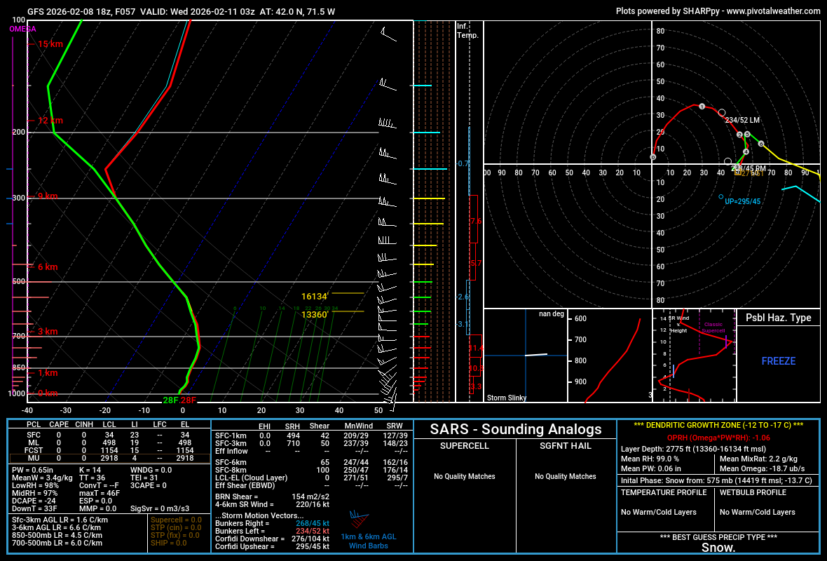
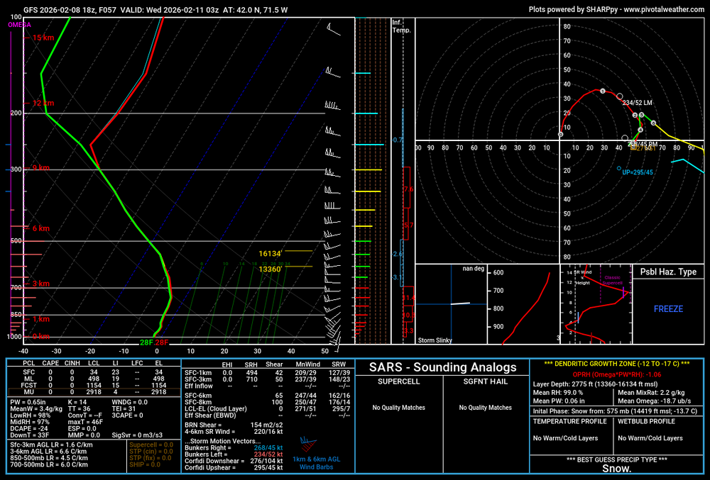
Woah 18z GFS
-
I think the CPC climate maps cause confusion for many. They are simply probabilities and should not be red and blue. People seem to think they are actual magnitudes. “Oh look dark red for this area, it’s going to torch!” Meanwhile the forecast is for 38-42 or a touch above. Same thing in July then it looks dark blue for 90-100% chance of below normal and the highs are 80-84. Below normal but just by a touch. They should also have a corresponding map that would show the estimated departure range. Just a thought since I see those tossed around a lot.
-

February 2026 OBS & Discussion
donsutherland1 replied to Stormlover74's topic in New York City Metro
The coldest day of Winter 2025-2026 is now going into the books. Tomorrow will start very cold, but the afternoon will be less harsh as readings climb into the middle and upper 20s. The temperature will reach or exceed freezing on Tuesday. The persistent and often severely cold pattern is poised to break near February 10th. However, exceptional warmth appears unlikely through at least mid-February, even as milder readings return. After mid-month, highs could begin to reach the lower 40s. The ENSO Region 1+2 anomaly was +0.1°C and the Region 3.4 anomaly was -0.4°C for the week centered around January 28. For the past six weeks, the ENSO Region 1+2 anomaly has averaged -0.38°C and the ENSO Region 3.4 anomaly has averaged -0.57°C. La Niña conditions will likely continue into at least late winter. The SOI was +0.05 today. The preliminary Arctic Oscillation (AO) was -3.397 today. Based on sensitivity analysis applied to the latest guidance, there is an implied near 90% probability that New York City will have a cooler than normal February (1991-2020 normal). February will likely finish with a mean temperature near 31.0° (4.9° below normal). Supplemental Information: The projected mean would be 4.3° below the 1981-2010 normal monthly value. Overall, Winter 2025-2026 is on track for a seasonal mean temperature of 31.8°. That would be the lowest winter mean temperature since Winter 2014-2015 when the mean temperature was 31.7°. Winter 2025-2026 would only become the fourth winter of the 21st century with a mean temperature of 32.0° or below. -
Put a sweater on and an extra quilt on the bed. Solved.
-
seriously, and it's killing my vehicles man, radiator, suspension stuff due to potholes and heaves, too cold to work on em yet too, and my salamander just shat the bed.
-
Yeah. I don’t get it. Deal with it.
-
Going to miss this glacier we have had for the last few weeks. Appreciate a real winter period for once.
-

Feb 10-11 Mid Week Minor Event - Ride the hot hand?
Baroclinic Zone replied to HoarfrostHubb's topic in New England
Add 18z GFS to list -
Feb 10-11 Mid Week Minor Event - Ride the hot hand?
Baroclinic Zone replied to HoarfrostHubb's topic in New England
18z Reggie looked pretty god. -

Winter 2025-2026 Offers Return to Normalcy
40/70 Benchmark replied to 40/70 Benchmark's topic in New England
Saturday Snowfall Forecast Verification Enhanced Areas Identified But Snowfall Under Forecast Reality Versus Eastern Mass Weather Forecast Map In order for a snowfall forecast to be truly elite, it is necessary to not only be highly accurate on a qualitative level (identify areas of heavier and lighter snowfall), but obviously it also needs to provide an accurate quantitative assessment of precisely how much snow will fall. When comparing the forecast to reality yesterday, it is apparent that the forecast was very accurate in the diagnosing which areas would be heavily impacted, while leaving much to be desired in that it greatly underestimated the snowfall in said areas. Dual Areas of Focus For Enhanced Snowfall The forecast on Friday identified one area of heavier snowfall associated with an inverted trough over central areas of the forecast area, and another zone of ocean-enhanced snowfall along the north and south shores of the Boston area. The placement of these areas nearly perfect, however, amounts were more on the order of 8-12"+ as opposed to the 3-6"+ that was denoted. Granted this was a very difficult forecast, that is a rather large discrepancy that had major implications for those impacted. Final Grade: B- -
Friday February 6 FROPA / WINDEX small event
40/70 Benchmark replied to HoarfrostHubb's topic in New England
Tough forecast yesterday, nailed the areas of enhanced snowfall, but the 3-6"+ forecast was definitely an inadequate range. I tried to convey the uncertainty by adding the "plus" sign, but that discrepancy undoubtedly left something to be desired. It was more like 8-12"+. I also should have had both areas of enhancement extend a bit further to the west. Grade that one on a curve a bit and say B- -
Is we back? February discussion thread
Baroclinic Zone replied to mahk_webstah's topic in New England
Why do some want to keep this cold? I’m all done with the $300-400 electric bills. -

Central PA Winter 25/26 Discussion and Obs
mahantango#1 replied to MAG5035's topic in Upstate New York/Pennsylvania
Gonna be a very cold night tonight. -

E PA/NJ/DE Winter 2025-26 Obs/Discussion
PhiEaglesfan712 replied to LVblizzard's topic in Philadelphia Region
I see it ending during the final days of February or the first days of March. After that, there will be a pattern change: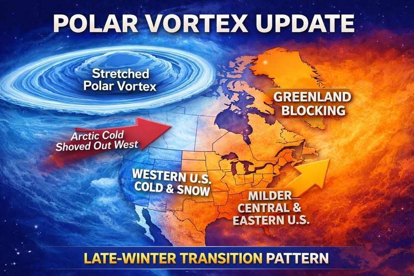
-
Back in the 70’s I was in high school and would have loved that scene . Today I am 63 and it takes too long a duration and too low of temperatures to get that result. I like my snow while it is falling then give it 2 days of a hard freeze and then I am ready for a break in the 60s.
-
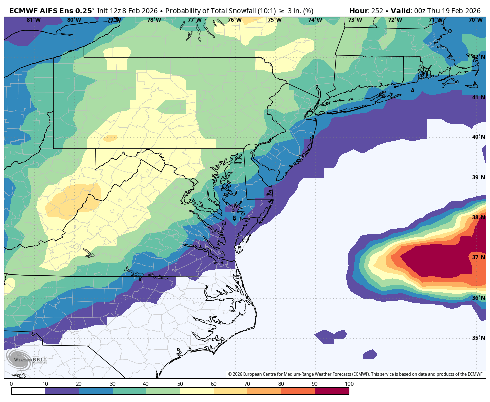
 really decent chance for 3" on the aifs ens, 40-60% for most