All Activity
- Past hour
-
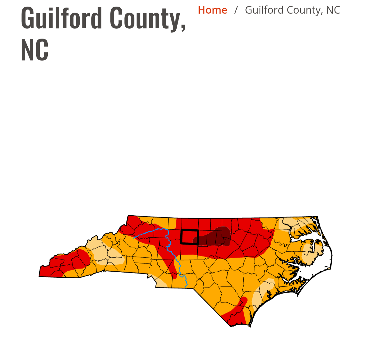
The drought stuff is out of control. There’s so many Mets out there that just blindly take Logan‘s record and run with it and make it look like that’s everyone across southern New England. It’s pretty obvious the two big snowstorms caused issues with catching the right amount of LEQ because all the other co-ops around Logan have a lot more from those two storms in terms of liquid equivalent than the ASOS. It’s not hard to dig a little deeper and see that. Yes it’s obviously been dry but not the record amount that’s being touted. People just diminish the science so much lately.
-
M0.82" yesterday. Absolutely poured for an hour. 2" PWATs baby.
-
Latest GFS doesn't show a whole lot of promise. the only "meaningful" rain fall set up looks to be next Tuesday and Wednesday. Sure the overall isolated/scattered afternoon storms seems like a good bet just about everyday. but only one real chance of an area wide rain through basically the end of the month.
-
June 11 2011: Severe thunderstorms bring extremely strong winds to central Minnesota. An unofficial wind gust of 119 mph is reported at a seed farm 1 mile northwest of Atwater. A storm chaser's car was battered when he got too close to the storm. Most of the windows in the car were broken. 1996: 5.91 inches of rain fall at Mankato. Mudslides close roads, including Hwy. 169, and push a trailer home 20 feet down a hill. 1922: A hailstorm at Maple Plain causes extensive damage to crops. For Thursday, June 11, 2026 1842 - A late season snowstorm struck New England. Snow fell during the morning and early afternoon, accumulating to a depth of ten to twelve inches at Irasburg VT. Berlin NH was blanketed with eleven inches of snow during the day. Snow whitened the higher peaks of the Appalachians as far south as Maryland. (David Ludlum) 1877 - The temperature at Los Angeles, CA, reached 112 degrees during a heatwave. It would have been the all-time record for Los Angeles but official records did not begin until twenty days later. (The Weather Channel) 1972 - Heavy showers brought 1.64 inches of rain to Phoenix AZ, a record for the month of June. (The Weather Channel) 1987 - South Texas endured another day of torrential rains. Up to twelve inches of rain drenched Harris County, and nearly ten inches soaked Luce Bayou, mainly during the afternoon hours. Thunderstorm rains left seven feet of water over Highway 189 in northern Val Verde County. Flooding caused nine million dollars damage in Real County. A thunderstorm at Perryton, TX, produced golf ball size hail and 70 mph winds, and spawned a tornado which struck a mobile killing one person and injuring the other four occupants. (The National Weather Summary) (Storm Data) 1988 - Thirty cities in the central and eastern U.S. reported record low temperatures for the date, including El Dorado, AR, with a reading of 48 degrees. Canaan Valley WV and Thomas WV dipped to 30 degrees. Flagstaff AZ was the cold spot in the nation with a low of 30 degrees. Coolidge, just 180 miles away, was the hot spot in the nation with an afternoon high of 105 degrees. (The National Weather Summary) 1989 - Thunderstorms produced severe weather in the south central and southeastern U.S. during the day and night. Thunderstorms spawned eleven tornadoes, including one which tore the roof off a restaurant at Bee Branch, AR, injuring six persons. The tornado tossed one car into the restaurant, and another car over it. Temperatures soared into the 90s across much of Florida. Lakeland reported a record high of 99 degrees for the second day in a row. (The National Weather Summary) (Storm Data) Observances: 11 Thu National Corn On The Cob Day 11 Thu Say Hi Day 11 Thu Yarn Bombing Day 11 Thu Kamehameha Day
-
It’s been 17 days since the last measurable rain here. The number of 2+ week rainless stretches dating back to last year insane, I wish I tracked that
-
Fwiw, NWS' climo Prelims have +2 to +5 at their 4 representative sites for SNE thru the first 10 days of June ORH/BOS are absurd and need to be changed, since climate affects POPULATIONS I suppose the Logan one has a sciency usefulness for how the coupling marine environments and all that jazz... but otherwise? no. Using that for "Boston" is just a thorn that is generations overdue to be pulled out. Doesn't matter what it takes or what hardship is perceived, if I were a fascist god, I would tell them to do so immediately or suffer the wrath of discontent that makes president Dump look like like the bed of daisies he's about start nourishing ( ...actually, they'd probably vomit, wilt and die ) ORH is a little less egregious. There are neighborhoods scattered around the AP up there on the hill, but because it's geo-physically always going to be 6 to 8 F cooler up there than the swelter below where there's many orders of magnitude more people actually living - to fairly use that as climate is jack shit, really.
-
0.40" of rain yesterday. Finally got a stm passing thru. Nice morning with more showers slated for the aftrn. As the Hudson LP develops, it's going to feel more like Spring for week than early summer. 60's/40's in the trough.
-

-
Got bullseyed for just under an inch of rain yesterday. Picked up .4 with the morning round and .55 with the evening storms.
-
Pretty “meh” feeling over this way. Lake Michigan and an overturned atmosphere (downstream) along with debris clouds vs an unusually strong June system. Lots of bust potential here. If things hold out or redevelop over this side of the pond then could be a big evening but timing is getting later and later and models looking messier/disorganized. I feel pretty confident in the Chicago area for some heavy weather after 7-8PM. 12z HRRR looks ugly.
-
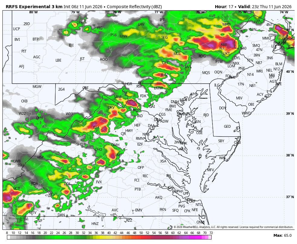
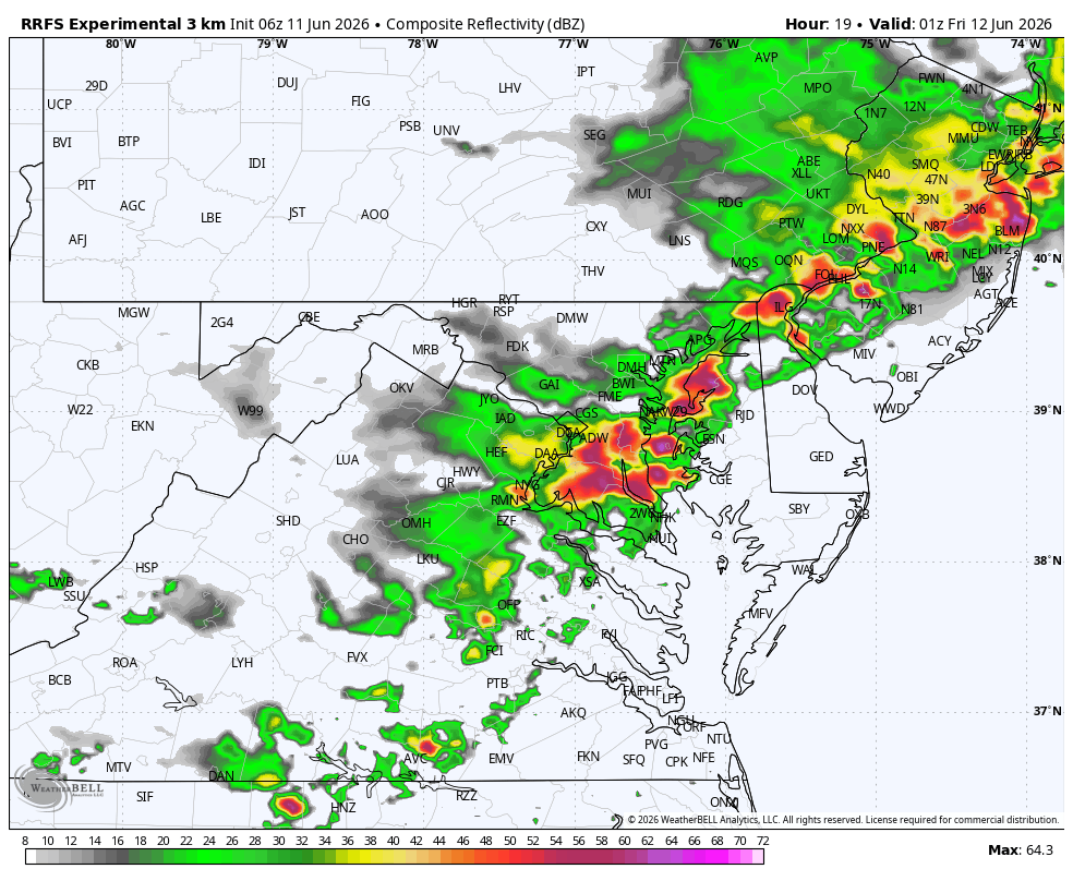
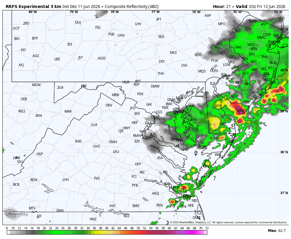
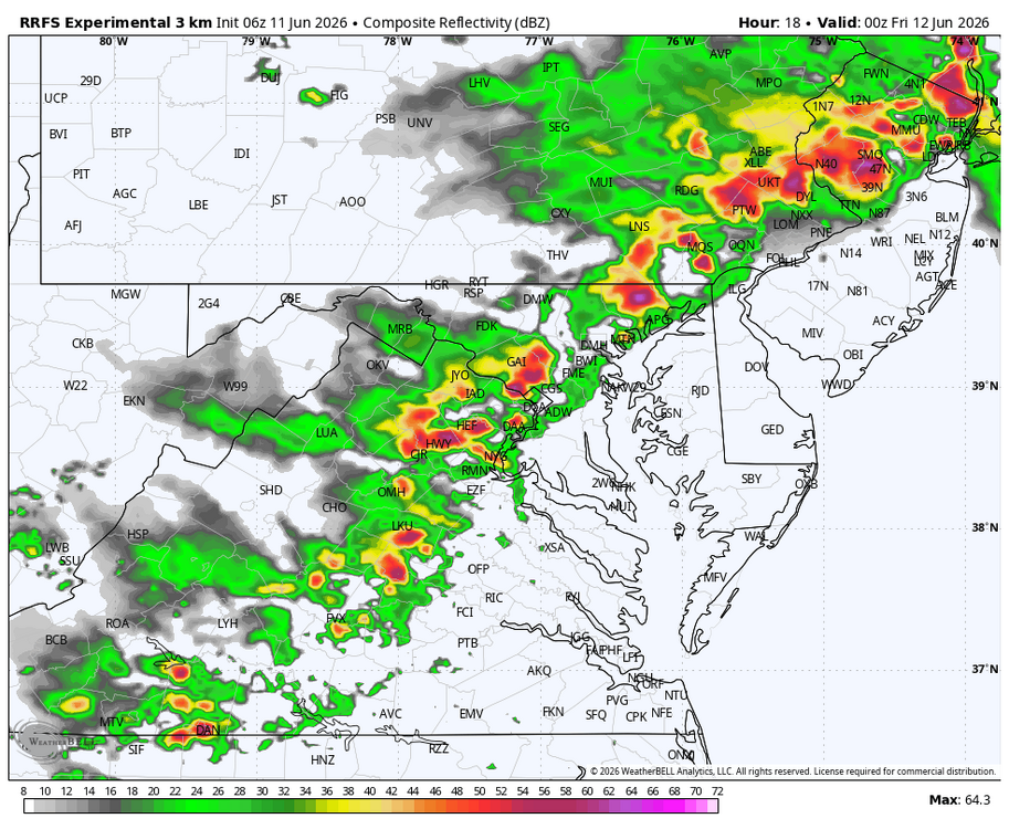
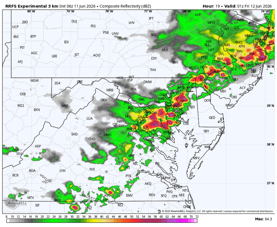
WB 6Z RRFS (been doing well with precip. Totals ). Squall line east of mountains around 7pm.


-
I wonder if data population schemes are more problematic in summer than winter. Maybe a known thing. Tracing that 500 mb vort paneling backward ...it seems the Euro/GFS are both getting an awful lot of momentum arriving out of the Pacific over the western continent around D5/6, then racing it into a bit of non-linear constructive interference triggering a shallow wave break and bombogenesis - originating along the lofty 570 mb height contour is a head scratcher. I guess it's not impossible... I mean, the models have to at least be physically possible otherwise they have 0 meaning.
-
.43 yesterday
-
Same weeks and weeks of rains... noone has harder rain than Templeton
-

2026-2027 Super El Nino
snowman19 replied to Stormchaserchuck1's topic in Weather Forecasting and Discussion
It’s official. NOAA has declared an El Niño -
All I know is after this weekend deep summer is canceled UFN.
-
77 instead of 72. Big effing deal.
-
-
always a bit of question whether these mcs cranking at a diurnally unfavorable time get over the hump and go long track, nice to see them going bullish
-
Major damage late last night/early this morning in the far north end of Springfield, IL. Especially near the fairgrounds. The Animal Protective League (local animal shelter) roof in some of their buildings were destroyed. Making those buildings a total loss. Also reports of power flashes near the State Fairgrounds. Lot of power outages stretching from the far north end of Springfield all the way to at least Decatur. And we weren't under last night's tornado watch (for Peoria/Galesburg/Bloomington areas) down here, although I'm thinking the actual watch box clipped the far north end of Sangamon County, plus much of Macon as well. Pre-2006, that would have been enough to put Sangamon and Macon counties in the watch. Stinkin' Lincoln (ILX) strikes again. https://www.wandtv.com/news/illinois/thousands-lose-power-during-overnight-severe-weather/article_2ef40d58-ec90-447e-962c-d2371b9a714d.html
-
Funny how the cig2 and highest risk just stops a few miles from the lake. SPC should know south of the metro into NWI is the QLCS tornado hotspot lol
-
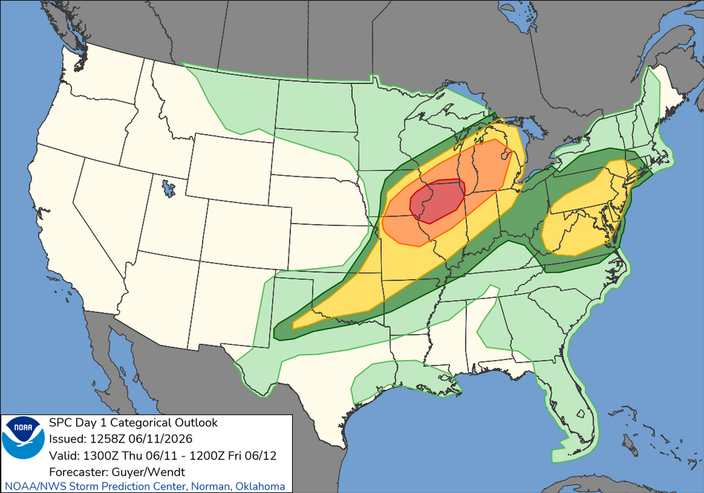
Finally came out on 1300z SPC OTLK
-
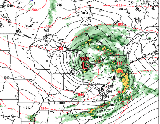
Look at this pig ... 984 mb low near BUFF, yet ... immersed in only 564 dm thickness, having almost no hydrostratic gradients surrounding all quads, either In summer. This is D7 Euro so... meh, no responsibility to accuracy is really there - yet - but that's an example of too much amplitude ( or likely to be...) on summer mid range charts. I like the triple point secondary low forming at the head of the 576 - that combination of metrics you don't typically see, huh
-

Junorch obs and discussion 2026
Damage In Tolland replied to Damage In Tolland's topic in New England
You are correct. No one had a WAN first half . Same will happen second half and Julorch . Both will warm as we get closer