All Activity
- Past hour
-
Depressing Euro run, if looking for snow. Rgem keeps it's decent snowfall set up. The Euro AI had some hope. The 06z gfs wasn't great for most of the forum. It's crazy to me that we see the looks at 500 that have been popping up and we are struggling to find modeled snow events. These looks would be productive throughout most of our climate history.
-

January 2026 regional war/obs/disco thread
Sey-Mour Snow replied to Baroclinic Zone's topic in New England
Yup, NOT with GFS leading the way.. Wait til the real models show a hit .. -
Sunday has legs! Let's keep the trends going today yall!
-

January 2026 regional war/obs/disco thread
Damage In Tolland replied to Baroclinic Zone's topic in New England
I’m not buying. We don’t get fooled again -
-
The lack of snow here in the lowlands is totally normal. Snow is rare here. The insane thing is that our local mountains have had basically nothing in years. I remember in the 90's Carroll County and the Catoctins we're the like Tug Hill of MD. I think the lowlands has done better than the Catoctins for many years now and that's not saying much. What's with that?
-

January 2026 regional war/obs/disco thread
mahk_webstah replied to Baroclinic Zone's topic in New England
I was in Philly for that. It was miserable. And I came home to an ugly old snow pack. The good news is,It will snow more and I don’t have to experience of watching that team play. They weren’t fun this year. -

Central PA Winter 25/26 Discussion and Obs
pawatch replied to MAG5035's topic in Upstate New York/Pennsylvania
24 degrees this morning. Thanks Blizz and MillvilleWX for maps and thoughts. What a roll coaster of a week. A little bit of everything. Doesn’t sound like the wind is going to be leaving us. 43 for the high yesterday. -

January 2026 Medium/Long Range Discussion
MDScienceTeacher replied to snowfan's topic in Mid Atlantic
On more serious note, does anyone know what teleconnection/ anomaly this is over Bering and how long before it breaks down? I have a trip to California planned for the last week of Jan and I am thinking this will have a direct impact on waves/ swells but it will likely need to break down first. I was hoping to see a big swell event along the coast.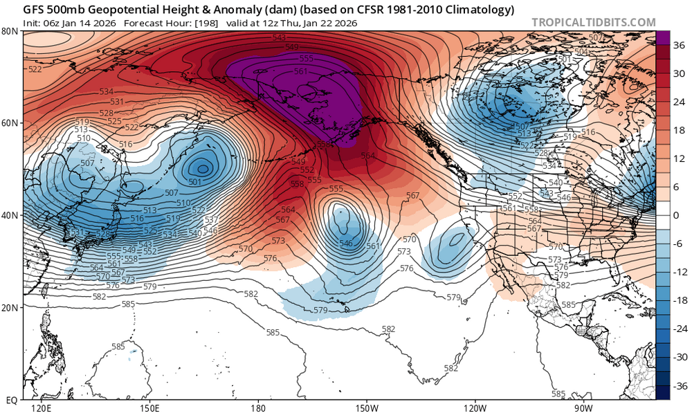
-
Will the negative interference from the torch guy prove good juju for some... time will tell

-
January 2026 Medium/Long Range Discussion
MDScienceTeacher replied to snowfan's topic in Mid Atlantic
The euro has a nice clipper at hour 348 -

Mid-Long Range Discussion 2026
gamecockinupstateSC replied to BooneWX's topic in Southeastern States
-
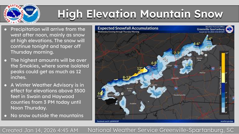
From GSP this morning. Sent from my SM-G998U using Tapatalk
-

Central PA Winter 25/26 Discussion and Obs
mahantango#1 replied to MAG5035's topic in Upstate New York/Pennsylvania
Flash freeze? Hazardous Weather Outlook National Weather Service State College PA 439 AM EST Wed Jan 14 2026 PAZ010>012-017>019-025>028-034>036-041-045-046-049>053-056>059- 063>066-150945- Elk-Cameron-Northern Clinton-Clearfield-Northern Centre- Southern Centre-Blair-Huntingdon-Mifflin-Juniata-Bedford-Fulton- Franklin-Northern Lycoming-Southern Clinton-Southern Lycoming-Union- Snyder-Montour-Northumberland-Columbia-Perry-Dauphin-Schuylkill- Lebanon-Cumberland-Adams-York-Lancaster- 439 AM EST Wed Jan 14 2026 This Hazardous Weather Outlook is for central Pennsylvania. .DAY ONE...Today and tonight. Rain mixing with or changing to snow along with plummeting temperatures below freezing could result in slippery conditions late tonight into Thursday morning. .DAYS TWO THROUGH SEVEN...Thursday through Tuesday. The probability for widespread hazardous weather is low. .SPOTTER INFORMATION STATEMENT... Spotters are encouraged to report significant hazardous weather. -

Winter 2025-26 Medium/Long Range Discussion
A-L-E-K replied to michsnowfreak's topic in Lakes/Ohio Valley
And it's gone.gif classic -

January 2026 regional war/obs/disco thread
dendrite replied to Baroclinic Zone's topic in New England
I like that 1045 high with yore Carolina CAD. -

January 2026 regional war/obs/disco thread
CoastalWx replied to Baroclinic Zone's topic in New England
Yeah still could go poof but it’s been inching west -

January 2026 regional war/obs/disco thread
ineedsnow replied to Baroclinic Zone's topic in New England
We can hope.. we need this! -
January 2026 regional war/obs/disco thread
CoastalWx replied to Baroclinic Zone's topic in New England
Still a nice overrunning signal in the extended -
GFS brings back the storm signal in that 9-10 day range we’ve seen
-

January 2026 regional war/obs/disco thread
UnitedWx replied to Baroclinic Zone's topic in New England
It's definitely inched closer the last several runs. Can the trend continue?... -
January 2026 regional war/obs/disco thread
ineedsnow replied to Baroclinic Zone's topic in New England
Ya that's been the one to watch.. might get a bit in the interior Saturday.. some models also starting to show that.. -
January 2026 regional war/obs/disco thread
CoastalWx replied to Baroclinic Zone's topic in New England
Euro AI a few inches too. -
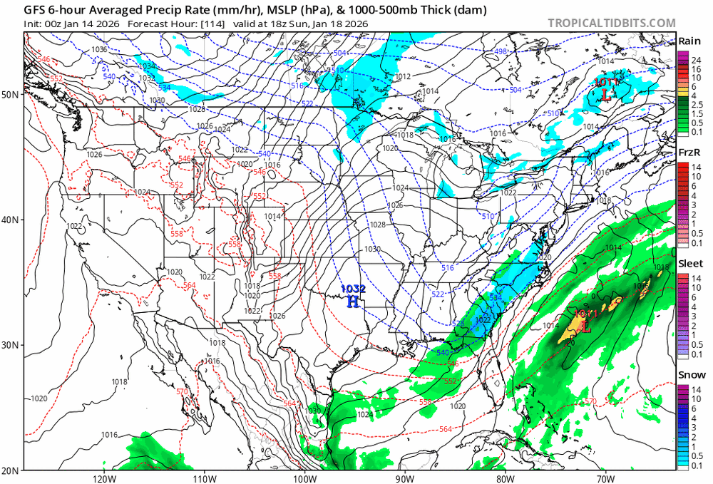
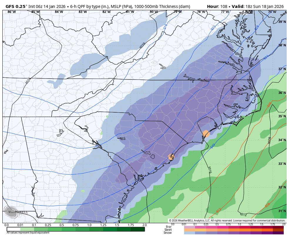
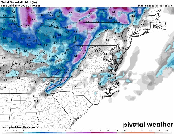
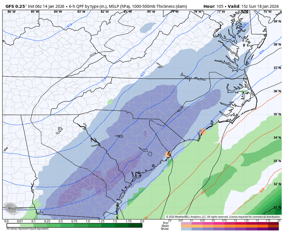
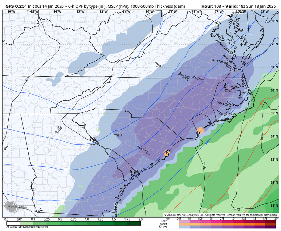
GFS is 2-4” from triad through triangle then 4-8” in the coastal plain with no mixing pretty much anywhere aka a pretty sweet storm as shown
-
GFS came nw again at 06z compared to 00z