All Activity
- Past hour
-
Honestly feels good to have the icon show it - it seems like it’s always the first model of the cycle to show a whiff/be bone dry.
-
We got some time unlike whatever small north trend happened on today’s VA storm
-
What is it going to take for us to get a strong CAD like the old days?
-
(002).thumb.png.6e3d9d46bca5fe41aab7a74871dd8af8.png)
E PA/NJ/DE Winter 2025-26 Obs/Discussion
ChescoWx replied to LVblizzard's topic in Philadelphia Region
The "trusty" ICON model highlight our next 2 winter "events" the first on Wednesday and the next on Friday night....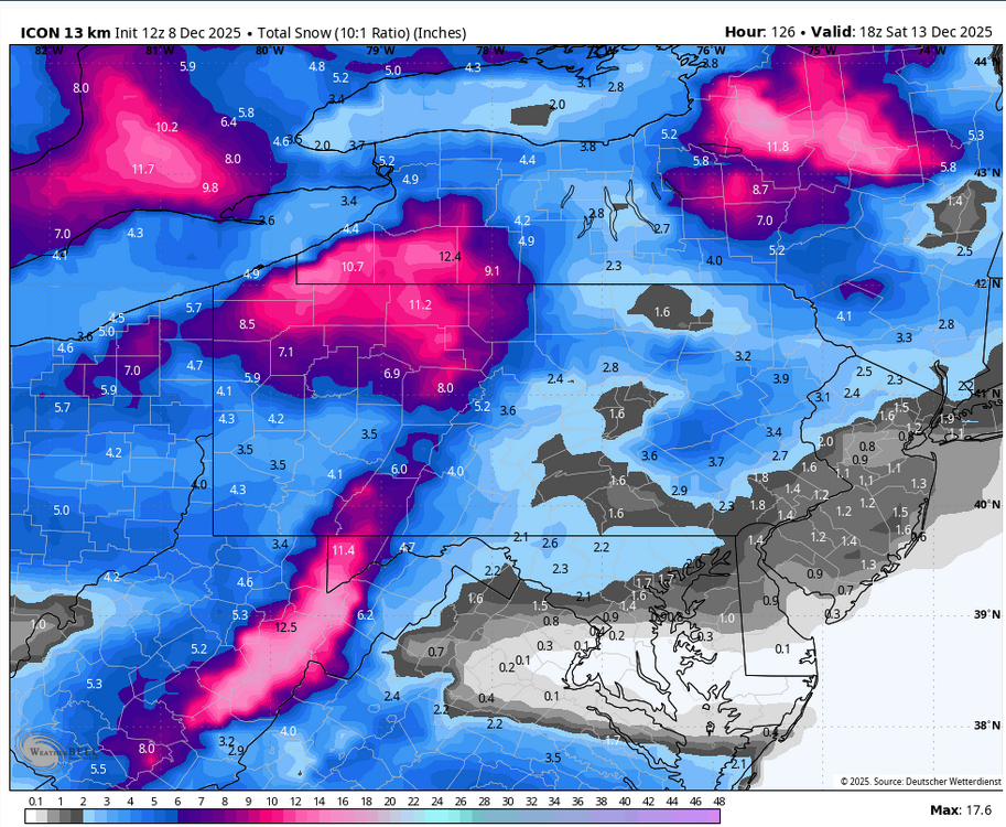
-
Yea looks like the heaviest rates are to the E/SE of the ROA valley. You all look to do a good bit better.
-

The Monday wintry event potential (12/8/25)
btownheel replied to GaWx's topic in Southeastern States
Snowing nicely in Gibsonville. . -
There is a big difference between annoying and annoying as F**K, you are getting above annoying as F**K.
-
Neighborhood roads caving
-

The Monday wintry event potential (12/8/25)
Buddy1987 replied to GaWx's topic in Southeastern States
Looking like the heaviest rates are going to be south of ROA for my direct area. Kind of a bummer there. -
Hope it keeps stepping
-
It's cold enough to snow here, but too cold to snow. Perfect vort pass for the Roanoke to Richmond crew.
-
Edited to say it looked closer to having it this time...confluence appeared to be weaker. If that trend continues at Happy Hour it may have it?
-
Congrats central and S VA folks! Enjoy it!
-
Baby step toward euro. Sharper vort and less confluence. Has some light precip west of the mountains.
-
Not even close
-
Gfs is a fart in the wind.
-
Snowing nicely here in Danville near 86 and 29 .
-
GFS looks tried to have it but still shredded it...Closer look than last time though
-

Winter 2025-26 Medium/Long Range Discussion
A-L-E-K replied to michsnowfreak's topic in Lakes/Ohio Valley
it's got that suppression stink, hopefully the snowier solutions gain favor here over the next couple days -
Well that’s all for this event folks. Precip orientation has now shifted NW to SE with this tail end, so that should effectively warm the air with Downsloping. Remember, no refunds allowed, please follow the exit signs accordingly as you get off the ride.
-

Richmond Metro/Hampton Roads Area Discussion
Midlo Snow Maker replied to RIC Airport's topic in Mid Atlantic
Elevation was key to early stickage in Powhatan. Higher elevation tops at windy hill and red lane hill where white, while lower areas around 288 and 711 had hardly anything, but this was an hour ago. -
I don't mind a warmup. My kids need to play outside (and me). 30s and rain is just miserable weather, especially with young kids who have tons of energy.
-

Winter 2025-26 Medium/Long Range Discussion
ChiTownSnow replied to michsnowfreak's topic in Lakes/Ohio Valley
AIFS has an interesting play as well on that dec 14thish system -
https://www.resortcams.com/webcams/blowing-rock/ The webcam out of Blowing Rock is simply amazing with the snow in the trees.
-
I agree, just making a joke. Lol


