All Activity
- Past hour
-

January 30th- Feb 1st ULL and coastal storm obs
sakau2007 replied to JoshM's topic in Southeastern States
snow is still coming down pretty good in Johnson City, TN, but with temps sitting at 31... it looks like roads are mostly still just wet. i presume that will change as we lose sunlight. -

Jan 30th-February 1st 2026 Arctic Blast/ULL Snow OBS Thread.
EastKnox replied to John1122's topic in Tennessee Valley
Medium flakes falling in East Knoxville. Temp 33 F, DP 27F -

Arctic Hounds Unleashed: Long Duration Late January Cold Snap
dendrite replied to WxWatcher007's topic in New England
33-34 was definitely cold here. 12/29 CON had their coldest max on record with -11. The afternoon high here was -15. CON did another below 0 high in Feb with -2. There were record low mins here too, but nothing that really stands out. -

Jan 30th-February 1st 2026 Arctic Blast/ULL Snow OBS Thread.
Carvers Gap replied to John1122's topic in Tennessee Valley
Exactly my experience, and part of the reason I really have struggled to buy-in with this. You and I both drove through the cutoff zone. It is abundantly apparent where it is...even now at this early stage. Now, if the 18z GFS and 12z Euro are right...more energy rotates back into our area overnight from slightly NE. I can't say I like seeing the cutoff already in place, but there may be more fireworks before we are totally cutoff from the lift. -
Solid. Solid!
-
Good luck to everyone and all the foothill folks. We are so overdue.
-
Everyone ready. We have been waiting for this opportunity for a long long long long time. Ladies and gentlemen. Let's get ready to rumble!!!!!
-

Jan 30th-February 1st 2026 Arctic Blast/ULL Snow OBS Thread.
GBOVolz replied to John1122's topic in Tennessee Valley
You know it’s been bad when we’re making posts about having a quarter inch of snow on the ground . -
Jan 30th-February 1st 2026 Arctic Blast/ULL Snow OBS Thread.
GBOVolz replied to John1122's topic in Tennessee Valley
Got a heavy dusting now. Probably close to a 1/4” . -

Jan 30th-February 1st 2026 Arctic Blast/ULL Snow OBS Thread.
John1122 replied to John1122's topic in Tennessee Valley
My 1/2 inch forecast has gone bust for MRX. -
Jan 30th-February 1st 2026 Arctic Blast/ULL Snow OBS Thread.
GBOVolz replied to John1122's topic in Tennessee Valley
lol.. . -

Richmond Metro/Hampton Roads Area Discussion
overcautionisbad replied to RIC Airport's topic in Mid Atlantic
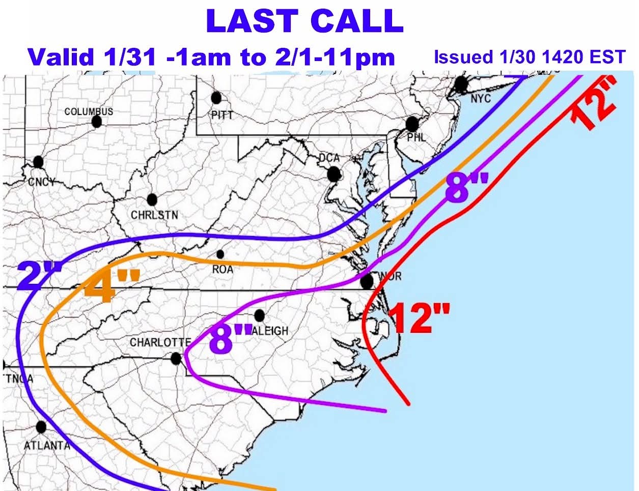
DT last call
-
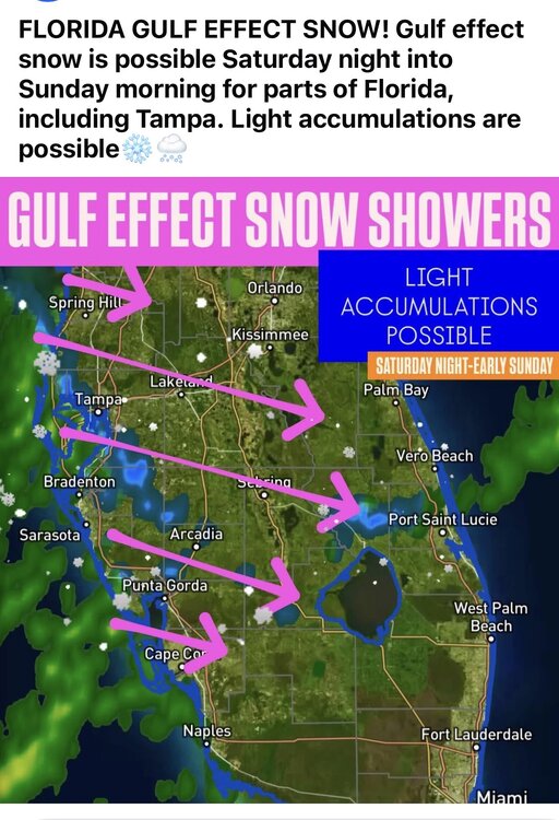
Meanwhile in South Florida...
-

Arctic Hounds Unleashed: Long Duration Late January Cold Snap
Roger Smith replied to WxWatcher007's topic in New England
Has there been much mention in this thread of the Feb 1934 cold records? Today's record low max at NYC is 16F set in 1934. December 1933 had been very cold but January 1934 up until this event had been near average. Then February produced record cold averages and extremes. The strongest of these arrived on Feb 8th with a 1050 mb high over Ontario. By morning of the 9th it was -15F near the coast and -30 to -50 F further inland. I believe both Saranac Lake NY and Bancroft Ontario (150 miles west of Ottawa) had lows near -52F. Lake Ontario froze over completely that winter. Toronto had an interval of 36 hours below zero F and a low of -21F on Feb 9th, NYC was -15F. So I wondered what data there might be for New England. A second record cold spell arrived in late February but it was not that extreme, about like today's values. -

Jan 30th-February 1st 2026 Arctic Blast/ULL Snow OBS Thread.
1234snow replied to John1122's topic in Tennessee Valley
This is what the 21z HRRR has for the next few hours. I think it may be off by a little bit! -
Arctic Hounds Unleashed: Long Duration Late January Cold Snap
dendrite replied to WxWatcher007's topic in New England
It was a pretty shallow cold shot. That kept max temps down because of lower mixing heights but the airmass itself isn’t exactly earth shattering. -

Jan 30th-February 1st 2026 Arctic Blast/ULL Snow OBS Thread.
Wurbus replied to John1122's topic in Tennessee Valley
Light snow started here about 10 minutes ago and down to 30.5 degrees. Only sticking on the deck and bare ground so far. -
 I’m in Dunwoody and hoping for 2-3 inches
 -

January 30th- Feb 1st ULL and coastal storm obs
WinstonSalemArlington replied to JoshM's topic in Southeastern States
Snow reported in Mount Airy and Danville -

Jan 30th-February 1st 2026 Arctic Blast/ULL Snow OBS Thread.
bearman replied to John1122's topic in Tennessee Valley
We are already getting white roofs. I guess the sun was filtered enough not to make much difference. -

Arctic Hounds Unleashed: Long Duration Late January Cold Snap
VivaManchVegas replied to WxWatcher007's topic in New England
Same here. It does not end. We get a few days here and there of 32 plus. Mid Feb a short break but it looks like another cold shot coming right in after that. -
January 30th- Feb 1st ULL and coastal storm obs
WinstonSalemArlington replied to JoshM's topic in Southeastern States
-

The “I bring the mojo” Jan 30-Feb 1 potential winter storm
Snowncanes replied to lilj4425's topic in Southeastern States
Put a piece of wood or cardboard down somewhere (if you really care about getting a perfect measurement) -

Jan 30th-February 1st 2026 Arctic Blast/ULL Snow OBS Thread.
Jed33 replied to John1122's topic in Tennessee Valley
Getting white around here now probably 1/4-1/3in on trees and grass. The temp has dropped to 28. -
2025-2026 Fall/Winter Mountain Thread
cold air aloft replied to Buckethead's topic in Southeastern States
Light flurries in Maggie.