All Activity
- Past hour
-
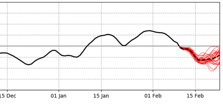
Period to watch if we could sneak a warm (50+) day in 2/17 - 2/20 period or will warmth be shunted south of PHL
-
(002).thumb.png.6e3d9d46bca5fe41aab7a74871dd8af8.png)
Central PA Winter 25/26 Discussion and Obs
ChescoWx replied to MAG5035's topic in Upstate New York/Pennsylvania
Here in the philly burbs of Chester County 3 stations set a new record for consecutive days below freezing at 17 days through yesterday. The old record was set way back in 1961.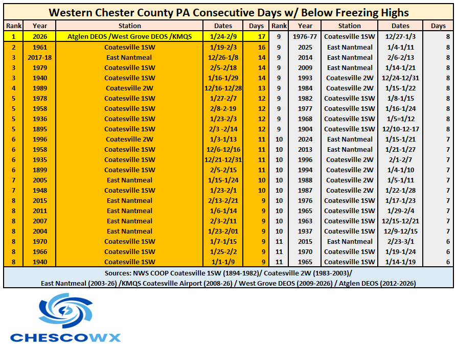
-
 Thank God I live in western Loudoun
 -
E PA/NJ/DE Winter 2025-26 Obs/Discussion
ChescoWx replied to LVblizzard's topic in Philadelphia Region
Here in the philly burbs of Chester County 3 stations set a new record for consecutive days below freezing at 17 days through yesterday. The old record was set way back in 1961.
-
Records: Highs: EWR: 63 (1990) NYC: 61 (2023) LGA: 60 (2024) JFK: 60 (2023) Lows: EWR: 8 (1968) - Unofficial record -9 (1899) NYC: -6 (1879) LGA: 4 (1979) JFK: 6 (1979) Historical: 1899 - The temperature at Monterey plunged to 29 degrees below zero, establishing record for the state of Virginia. (Sandra and TI Richard Sanders - 1987) 1899: The minimum temperature for the date was -8 °F and the high was + 4 degrees F. in Washington, DC. The + 4 degrees F. high was the lowest maximum ever recorded in Washington. That makes this day one of only five days in the official climate history of Washington (11-1-1870- present 2003) to have a maximum temperature less than 10 degrees F. The first time was on 12-30-1880 when the high was 9 °F and the second was 12-30-1917 when the high was 9 degrees F. A high temperature of 8 degrees has occurred twice also - the first time was this date (1-13-1912) and the second time was 1-19-1994. (Stanley Rossen email of December 31, 2002)(Ref. Wilson Wx. History) Coldest ever in Virginia it was -29°F Monterey in 1899 a record that stood until Jan. 22nd, 1985 when it was -30° below zero. This is still the VA all time record low temperature. The temperature in Milligan, Ohio plunged to -39° below zero in 1899, for a all time state record to the present (2010). (Extreme Weather p. 54, by Christopher C. Burt) 1921 - Gardner, Georgia, was devastated by a massive, estimated F4 tornado that caused an entire small town section to disappear. The tornado killed an estimated 31 people and injured 100. 1921: Gardner, Georgia, was devastated by a massive, estimated F4 tornado that caused an entire small town section to disappear. The tornado killed an estimated 31 people and injured 100. 1933: The temperature in Seneca, Oregon plunged to -54° below zero, for a new state record. It would be over 100° warmer the next day with a high temperature of 45°. (Extreme Weather p. 54, by Christopher C. Burt) (Ref. Wilson Wx. History) 1959 - St. Louis, Missouri, was hit by a massive F4 tornado that killed 21 and injured 345. Over 2000 buildings were damaged or destroyed, including the St. Louis Arena. 1973 - A major snowstorm struck the southeastern U.S. It produced as much as 18 inches in Georgia, and up to two feet of snow in South Carolina. (David Ludlum) 1978 - As much as eight inches of rain drenched southern California resulting in widespread flooding and mudslides. The heavy rainfall produced a wall of water which ripped through the mountain resort community of Hidden Springs drowning at least thirteen persons. The storm was one of the most destructive of record causing fifty million dollars damage. (David Ludlum) 1981 - A morning tornado at Bay Minette, AL, struck the local middle school severely damaging the gymnasium. 62 people were injured, 44 of whom were students. 1982 - Bismarck, ND, experienced its 45th consecutive day of subzero temperature readings which tied the previous record long string of subzero daily lows ending on the same date in 1937. (David Ludlum) 1983: On February 10, 1983 a huge snowstorms swept up the eastern seaboard, burying the Virginia Washington area in a swath of very heavy snow. During the late evening of February 10th a low over Georgia started giving a light snow to the Washington, DC area. The snow slowly picked up in intensity during the overnight hours and by morning the surface low was positioned just east of Wilmington, North Carolina. A tight pressure gradient between the storm and a high-pressure area to the north causing winds to increase to gust over 40 mph and snowfall rates of 3 inches per hour were common. Many observers particularly in the Maryland suburbs reported several episodes of lightning and thunder. Most of the southern and eastern suburbs recorded 15 to 20 inches of snow while 20 to 30 inches of snow fell in the northern and western suburbs. National Airport received 16.6 inches while 22.8 inches fell at both BWI and Dulles Airport. In Northwest Montgomery and Frederick Counties the storm was the greatest ever recorded easily exceeding the totals received during the famous Knickerbockers storm of January 1922. Germantown and Frederick both receive 30 inches of snow and western Loudoun County, Virginia, up to 38 inches. Braddock Heights, just west of Frederick, Maryland, received 34.9 inches. Areas to the east and a little south of Washington received snow pellets mixed with snow thus reducing the accumulations there. (p. 90 Washington Weather Book 2002 by Ambrose, Henry, Weiss) (Ref. Wilson Wx. - More Information About This Storm) Ref. (NWS Ranking for Storms between 1956 and 2011) This is the 10th Worst Snowstorm 1987 - A storm in the northeastern U.S. produced heavy snow in southeastern Maine. Grand Falls and Woodland received 15 inches, mainly during the early morning hours, while most of the rest of the state did not even see a flake of snow. (The National Weather Summary) (Storm Data) 1988 - Bitter cold arctic air gripped the north central U.S. International Falls MN was the cold spot in the nation with a low of 35 degrees below zero. Record warm readings were reported in southern California, with highs of 78 at San Francisco and 88 at Los Angeles. San Juan Capistrano CA was the hot spot in the nation with a high of 92 degrees. (The National Weather Summary) 1989 - For the first time all month winter relaxed its grip on the nation. The temperature at Brownsville TX warmed above 60 degrees for the first time in six days, ending their second longest such cold spell of record. (The National Weather Summary) 1990 - Thunderstorms developing ahead of a cold front continued to produce severe weather across the southeastern U.S. through the morning hours and into the late afternoon. There were a total of twenty-nine tornadoes in twenty-nine hours, and 245 reports of large hail or damaging winds. Pre-dawn thunderstorms produced high winds which injured at least seventy persons in Alabama and Georgia, and caused more than twelve million dollars property damage. A tornado at Austell GA prior to daybreak injured two persons and caused two million dollars damage. (The National Weather Summary) (Storm Data) 2010 - A second major snowstorm, dubbed Snoverkill and Snowmaggedon 2.0, further buries the Nation's Capital with 10.8 inches of new snow. Schools, businesses and even parts of the Federal government are shut down by blizzard conditions. The city now has a deeper snowpack, 28 inches, than the 20 inches in Anchorage, AK, or 27 inches in Marquette, MI. 2011 - The coldest day in Oklahoma history sees the temperature plunge to -31°F at Nowata, OK. A US National Weather Service station at Bartlesville recorded a reading of -28°F. Both locations break the previous low temperature mark of -27°F set in 1905 and tied in 1930. The Weather Doctor 2017: An atmospheric phenomena know as "moonbow" was seen in the Seattle area. 2017 - Denver saw their all-time warmest temperature in February with a reading of 79 degrees.
-

Central PA Winter 25/26 Discussion and Obs
Voyager replied to MAG5035's topic in Upstate New York/Pennsylvania
I hear ya, and yes, to each their own. While I can't totally relate to loving cold weather, it's cool that we all have our preferences. -
How can I generate similar maps? Is this a subscription based site? Thanks.
-

Is we back? February discussion thread
40/70 Benchmark replied to mahk_webstah's topic in New England
I think the majority understand it and are just sick of hearing it- -

Feb 10-11 Mid Week Minor Event - Ride the hot hand?
CoastalWx replied to HoarfrostHubb's topic in New England
HRRR juices Ray to SNH but went a little flaccid SoP. Sort of makes sense. -
Is we back? February discussion thread
40/70 Benchmark replied to mahk_webstah's topic in New England
I did have 2018 in my February composite largely due to the strat, so I could see shorted-lived arm interval. -
23 / 11 the ascent from the ice box continues mid / upper 30s today and Some areas to or low 40s on Wed (last time 1/22). Overall drier through the yet to be sorted out 2/15-2/16 storm system which looked mainly mix/wet. Moderation and warmer next week - still hovering between cold to the north and much warmer to the south and we'll see if one or two days between the 2/17 - 2/21 period gets to 50(s) - last was Jan 12-14th. Beyond there overall near normal to below.
-
This was exactly what I was thinking this morning when looking at this ... 5 weeks of predominantly +PNA ( with oscillation no less, a typically favorable behavior). Yet, jack shit zilch squat response in specifically that. I know folks either don't understand this, or are sick of hearing it ... but, the over-arcing -AO that took place nearly collocated in time produced a velocity anomaly. This is expressed in two ways ...well three. 1, the compression/intense planetary gradient immediately generates a high basal wind flow. 2, because of that ( lengthening U component in the Navier Strokes-it ) the wave function responds by speeding up the S/W wave speeds. 3, the patterns are "idiosyncratically unstable", a bit more complex.. Those are all indirect/non-lineary negative interference constraints .. Everything else on your list were the constructively favored. I fully believe this has porked organized cyclogen from materializing out of the occasional hyper-bomb fantasia of the modeling cinema per the course.
-
Is we back? February discussion thread
40/70 Benchmark replied to mahk_webstah's topic in New England
Same....especially in December. I thought December would be full of SWFEs. -
Feb 10-11 Mid Week Minor Event - Ride the hot hand?
CoastalWx replied to HoarfrostHubb's topic in New England
No idea what you mean. Lol -
Great point. Outside of a single, great event this season has had a lot of low impact fluff-jobs as Dick Albert used to say. Saturday was the ultimate stat-padder.
-
Going to be a mess with frozen ground-even at 33-34 degrees could be an issue on untreated roads
-
 Oh my! I was about to give up completely on this. Just checked the Euro for fun thinking it was gonna be showing a major rainstorm or nothing.
 -

Feb 10-11 Mid Week Minor Event - Ride the hot hand?
Ginx snewx replied to HoarfrostHubb's topic in New England
You mean absolutely nailed the pattern and the last 4 storms that kind of wild. -

Feb 10-11 Mid Week Minor Event - Ride the hot hand?
HoarfrostHubb replied to HoarfrostHubb's topic in New England
I know it was just a coating/dusting this morning, but what a disaster on the roads on my drive to work. State highway in Gardner iced up, as was Rte 2 -

Feb 10-11 Mid Week Minor Event - Ride the hot hand?
dryslot replied to HoarfrostHubb's topic in New England
I know they like to use them and the NBM, So if those are right, Yes. -
Temp hit 7.0 around 7:30 am yesterday morning, tied the record low for the day with 1989. Currently 19.4/14.4 at 8 am here with a partly cloudy sky (high cirrus). Even if NWS is off 8 degrees like yesterday, the 55 high forecasted will be mid/upper 40's, should see some melting.
-
I thought there would be more SWFE’s this year.
-

February 2026 Medium/ Long Range Discussion: 150K Salary Needed to Post
TSSN+ replied to Weather Will's topic in Mid Atlantic
If we get any snow this weekend even 1/2” he needs to voluntarily delete his account. -

Feb 10-11 Mid Week Minor Event - Ride the hot hand?
moneypitmike replied to HoarfrostHubb's topic in New England
Think they’re right? Id love s snow day. -
 And right after this sniveling post, the Euro came back. Will it be right? Probably not, but i don’t know that enough to make declarative statement about what I’m tracking. Go write a nasty PM to ECMWF about it.

.thumb.jpg.f0d4bc69c0baaceecd7d96541f839c25.jpg)


.thumb.png.4150b06c63a21f61052e47a612bf1818.png)

