All Activity
- Past hour
-

Possible coastal storm centered on Feb 1 2026.
Damage In Tolland replied to Typhoon Tip's topic in New England
50-75 miles dumps feet . It’s such a beast you don’t need a 40/70 track . It is going to snow -

The “I bring the mojo” Jan 30-Feb 1 potential winter storm
Buddy1987 replied to lilj4425's topic in Southeastern States
It’s almost like what the northeast would experience with a Norlun Trough.. pretty cool stuff. -

Possible coastal storm centered on Feb 1 2026.
The 4 Seasons replied to Typhoon Tip's topic in New England
You take that birthday wish back! -

Pittsburgh/Western PA WINTER ‘25/‘26
MikeB_01 replied to Burghblizz's topic in Upstate New York/Pennsylvania
Based on this and the analogs that I shared earlier, I don’t think it’s crazy to keep it on the table. I don’t think we will get 8+, but not a bad look to hope for a 2-3” event. Plus it will be so cold everything will pile up quick . -

January 2026 regional war/obs/disco thread
Torch Tiger replied to Baroclinic Zone's topic in New England
February thread? Not much to discuss until D10? -

Possible coastal storm centered on Feb 1 2026.
tiger_deF replied to Typhoon Tip's topic in New England
It's encouraging that the tracks leaning to the west aren't less deep than the ones east of the benchmark. While chances might have slipped a little bit last night into today, there's still a real possibility of a big one -
Wester
-
Hoping we can get that shifted 50 miles or so west. Being pretty far inland never had so many 40+ mph gusts in a 4-5 hr period with moderate snow falling. 7” plus some prior snow made 2-3 ft drifts.
-
AI GFS looks like a slight step back on the coastal. Still further west than AI Euro, and it also has that initial slug of moisture further North to start. As others have noted, that might be a way to salvage a small snowfall if the main event fails to develop.
-
lol, it might even be better
-
Finished with 19.6" with a mere 0.77" LE for ratio 25.5-to-1. Even without the freakish 6" of 75:1 superfluff the remainder was near 20:1. It's by far the biggest snowfall with 25+ ratio; next biggest was Feb. 11-12, 2017, when a 1-3 forecast verified as 8.0" feathers drifting on a steady light north wind - only 0.26" LE, 30-8-to-1. Nearest cocorahs (Farmington 4.2NNW, about 10 miles NW from here) reported 19.5".
-

The “I bring the mojo” Jan 30-Feb 1 potential winter storm
wncsnow replied to lilj4425's topic in Southeastern States
This meso low could mean business. -
The “I bring the mojo” Jan 30-Feb 1 potential winter storm
wncsnow replied to lilj4425's topic in Southeastern States
AIGFS crushes western Piedmont -

Pittsburgh/Western PA WINTER ‘25/‘26
Rd9108 replied to Burghblizz's topic in Upstate New York/Pennsylvania
Think you meant west?? -
Just got to 72...looking like a hold SO FAR
-

Possible coastal storm centered on Feb 1 2026.
Snowcrazed71 replied to Typhoon Tip's topic in New England
Lol... That doesn't look so bad at all.... Lots of members to the West, even on shore -
Possible coastal storm centered on Feb 1 2026.
Damage In Tolland replied to Typhoon Tip's topic in New England
Why? -
High of 22.
-

Possible coastal storm centered on Feb 1 2026.
ineedsnow replied to Typhoon Tip's topic in New England
I give up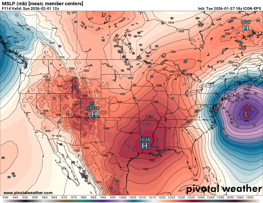
-
Think we should wait till 72-81 hours to call it. But you're probably right
-
What caught my eye: "It is worth noting that, while the EC-AIFS has largely performed well inside of 5 days much of the winter season, the EC- AIFS and ECMWF did suppress the track of the most recent winter storm too much ~4-5 days out before correcting northward inside of 72 hours out."
-
I guess you could make the argument that the 18z GFS is a very, very, very slight bit better than 12z at h5, but otherwise, it's a carbon copy so far.
-

Possible coastal storm centered on Feb 1 2026.
Wxbear25 replied to Typhoon Tip's topic in New England
Ok Franklin Delano Romanowski -

January 2026 Medium/Long Range Discussion
North Balti Zen replied to snowfan's topic in Mid Atlantic
just an "ahem" to everyone - as long as this particular poster is noting this, I remain interested... Thanks for the drop-in, Pete. -
The “I bring the mojo” Jan 30-Feb 1 potential winter storm
Buddy1987 replied to lilj4425's topic in Southeastern States
GFS looking very similar thus far at hr 48. Key is somewhere between hr 84-90 to see the trough axis and pivot point in my mind.


