All Activity
- Past hour
-
 Certainly looks like there will be some risk for strong-to-severe storms
 -

Central PA Summer 2026 Discussion/Obs Thread
canderson replied to Voyager's topic in Upstate New York/Pennsylvania
Car read 86 in Lemoyne a few minutes ago -
 Wed is a big severe threat . At least SNE
 -
They’re extremely shook. You love to see it
-

2026-2027 Super El Nino
40/70 Benchmark replied to Stormchaserchuck1's topic in Weather Forecasting and Discussion
How is 2015 a poor analog? 2015: 15JUL2015 region 1.2 2.7 region 3 1.9 region 3.4. 1.4 region 4. 1.1 2026: 15JUL2026 region 1.2 3.6 region 3. 2.3 region 3.4. 2.1 region 4. 1.1 1997: 16JUL1997 region 1.2 3.8 region 3. 1.9 region 3.4. 1.4 region 4. 0.4 2026 is even stronger everywhere else, but region 4 is identical. Technically, this is more east-based than 2015 because there is simply more heat back east, and region 4 is the same, but 1997 was def. more east-based. Neither of them are perfect, but I prefer 2015 because in 1997 region 4 wasn't even in El Niño territory....but again, I think it's irrelevant. Region 4 is leveling off, as it was in 2015 at this time if you look at the data...dropped down from 1.1 to .7 by July 29th. I think you are unnecessarily splitting hairs...we can all agree there is too much warmth east for this to act like a Modoki. It's basin-wide that will act like and east-based in the mean bc of all of the warmth back east, but there will be more volatility than a strictly east-based event. -
Doesn't really look like a washout to me this week. Looks to be more daytime heating driven scattered-to-numerous showers and thunderstorms. But Tuesday into Wednesday may have a solid line of very heavy rain and thunderstorms moving through at least part of the region.
-
Only "leaning" AN, so even if right, possibly muted at times.
-
2026-2027 Super El Nino
40/70 Benchmark replied to Stormchaserchuck1's topic in Weather Forecasting and Discussion
Yes, very plausible. -
100+ for Miles City Montana though next Saturday. It's that 'dry' heat though. Currently 105 with a dp of 42
-
2026-2027 Super El Nino
40/70 Benchmark replied to Stormchaserchuck1's topic in Weather Forecasting and Discussion
I think @raindancewxhad the right idea....it will fade to just either side of neutral for winter. -

Occasional Thoughts on Climate Change
donsutherland1 replied to donsutherland1's topic in Climate Change
His understanding of climate/weather is poor. He knows day-to-day weather, but cannot put the pieces together in the larger context, much less as it relates to climate. That, IMO, is a big reason that he is not working in the profession he studied. His poor social skills are the other big reason. A quick comparison is in order for illustrative purposes: The Dust Bowl: - Occurred in a cooler climate regime (globally, the 1930s were relatively cool compared to recent decades) - Was a regional phenomenon from drought coupled with bad land use practices that amplified the severity of the drought, drying the soil even more and amplifying the heating June 2026 European Heatwave: - Occurred in a much warmer global climate (June 2026 ranked as the second warmest June on record) - Occurred within the context of rapid warming in Europe (climate change-forced quasi resonant amplification is contributing) - Spain is undergoing aridification - The extreme heat is an outcome one would expect from a rapidly warming climate Confusing or conflating the two events as he does means confusing weather with climate. The Dust Bowl demonstrates how regional weather and land misuse can produce catastrophe, whereas the 2026 European heatwave demonstrates how ordinary atmospheric variability now operates within a warmer climate system that makes exceptional heat more intense, extensive and likely. -
Sorry, I relied upon stats shared by meteorologist Matthew Huddleston
-
 Maybe it’ll be like usual where the weather does the opposite of your worries?
 - Today
-
Multiple CAMs break out scattered showers (thunder?) in the area Sunday afternoon lasting into the evening.
-
-
.thumb.gif.f92b16c631a1d15d405ed77b33f0710d.gif) It won't?
It won't? -
Pretty interesting h5 pattern setting up for the US will produce weather extremes. I'll take our area for this one. WPC EFD- ...Weather/Hazards Highlights... Extreme heat will continue to make weather headlines across a large expanse of the country going into next week. Widespread upper 90s and low 100s are expected from Montana to the Dakotas, which is about 10-15 degrees above average. It will also be very hot and humid from Texas to the Gulf Coast states with highs ranging from 95 to 105 degrees on most days, with some areas of extreme HeatRisk given the longevity of the heat and expected heat indices exceeding 110 degrees at times. It will also be quite hot from the Desert Southwest and extending north across the Intermountain West with the upper ridge exerting its influence. Highs in the 110s to 120F in the hottest deserts of southern Arizona/southeastern California will only cool into the upper 80s to mid 90s at night. Farther north, temperatures near 100 degrees will be common over the Great Basin. Over the Northeast/Mid-Atlantic, upper troughing will favor near to below normal temperatures in the generally pleasant 70s/80s during the day and 50s/60s at night. An organized low pressure system crossing the Northeast and Mid- Atlantic region on Tuesday, in combination with an amplifying upper level shortwave trough, will fuel the development of numerous showers and storms from Virginia to New England. A risk of flash flooding is possible in the region Tuesday into Wednesday with a potential for 1 to 2+ inches of rainfall. There is also a threat of severe weather across portions of the Mid-Atlantic in the warm sector of the low pressure system. Damaging winds are the primary hazard with the strongest storms.
-
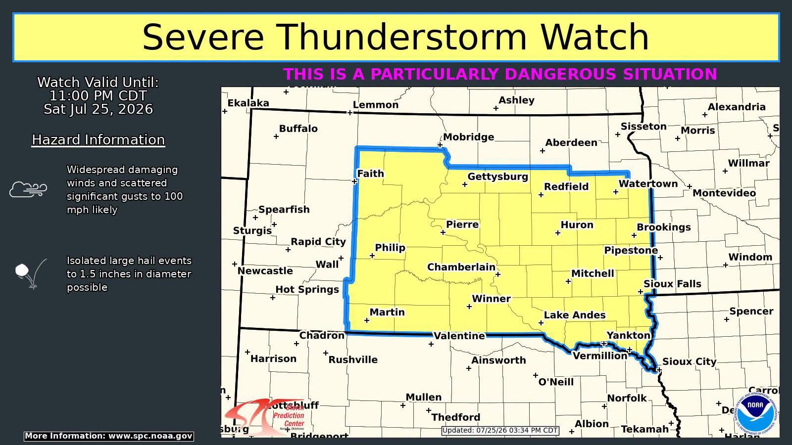
The rare PDS Severe Thunderstorm Watch up in SD.
-
 You don’t say
 -
We're in the Falls watershed near Laurel Creek (a couple of miles SW of the NC50/NC98 intersection) so we drain into Falls Lake. July to date: 9.1" +4.1" over the last few days = 13.2" We had 4.6" in June, so almost a foot and a half of rain for June/July. We're on a a community well, so our water restrictions are based on the drought intensity ratings. We've now dropped from D4 to D3 to D2 on successive weeks. The trend is your friend :-)
-
Brutal and their reservoirs are already at historic lows. Nino fall and winter can’t come soon enough for these people.
-
Chris put out this yesterday. I hate his confrontational juvenile behavior, which is totally unnecessary. Ignoring that and acknowledging that 1936 was made much worse due to very dry soils/drought, does he have a valid point about a possible double standard in the treatment of 1936 and 2026 European heatwaves? After all, they were both regional and 1936 covered a much larger area I believe: This is the 2nd part: The recent European heatwave was also regional. But for whatever reason, that is supposedly “incontrovertible proof” of catastrophic, rapid global climate change. I really want to know how any person can have this level of mental retardation. *Also, I’ve been reading some things regarding the magnitude of the Obs Time Bias possibly being exaggerated. I’ll probably post some of this later to get your thoughts.
-
 Who cares it will be over soon even if winter sucks it wont be hot
 -
 Were porked here. Euro is a flooded from Tuesday day through Sat
 -
ACATT reeling hopefully an unforgiving Ughust