All Activity
- Past hour
-
meanwhile up here in ville, 9" of snow, and 1.5" of rain MTD
-
Thursday night looks like another round
-

2026-2027 El Nino
snowman19 replied to Stormchaserchuck1's topic in Weather Forecasting and Discussion
My guess is that we will have a completely different stratosphere/SPV this coming winter given the anticipated +QBO/El Niño/+IOD -
felt like a january morning today..
-
I noted this active wx pattern in my Holiday forecasts for April 1, and Easter weekend. Rough part is that I still can get some sn/ice out of this, especially at night/early morning.
-
Nice day today with highs around 40. Looks like a mix coming for Wed-Thurs. Then a quick shot of cooler wx.
-
Two storms between 22 and 24” probably would justify an A or close to it, but it also felt like only a 5-6 week blitz and not much more. It was cold in December into January but not a whole lot to show for it which left a sour taste in my mouth. Same with March. Also as greedy as this sounds, being 10 miles away from something historic kind of left you wanting more too. But I certainly will take all of this over the absolute garbage we’ve had recently. Once the snow finally came around MLK, it stayed into the second week of March. I guess a B+.
-
March 24 1851: Minnesota experiences an early spring 'heat wave' with 60s and 70s common. For Tuesday, March 24, 2026 1912 - Residents of Kansas City began to dig out from a storm produced 25 inches of snow in 24 hours. The snowfall total was nearly twice that of any other storm of modern record in Kansas City before or since that time. A record 40 inches of snow fell during the month of March that year, and the total for the winter season of 67 inches was also a record. By late February of that year Kansas City had received just six inches of snow. Olathe KS received 37 inches of snow in the snowstorm, establishing a single storm record for the state of Kansas. (23rd-24th) (The Kansas City Weather Almanac) (The Weather Channel) 1987 - A winter-like storm in the central U.S. produced blizzard conditions from South Dakota to western Kansas. Snowfall totals ranged up to 24 inches at Neligh NE, with 19 inches at Winner SD. Winds gusting to 60 mph created twelve foot snow drifts in Nebraska stranding thousands on the highways. (Storm Data) (The National Weather Summary) 1988 - Thunderstorms developing along a cold front produced severe weather from Minnesota to northeastern Texas. The thunderstorms spawned ten tornadoes, including one which injured five persons near Raymondville MO. (The National Weather Summary) (Storm Data) 1989 - Low pressure off the coast of Virginia brought heavy rain to the Middle Atlantic Coast States, and heavy snow to the Northern Appalachians. Cape Hatteras NC was soaked with 5.20 inches of rain in 24 hours, and snowfall totals in Vermont ranged up to 12 inches. Winds gusted to 52 mph at New York City. (Storm Data) (The National Weather Summary) 1990 - The storm system which produced heavy snow in the Lower Missouri Valley the previous day, spread heavy snow across parts of the Upper Ohio Valley and the Middle Atlantic Coast Region. Snowfall totals of 2.2 inches at Philadelphia PA and 2.4 inches at Atlantic City NJ were records for the date. Up to six inches of snow blanketed southern Ohio. In the Middle Atlantic Coast Region, snow coated the blossoms of cherry trees which had bloomed in 80 degree weather the previous week. (Storm Data) (The National Weather Summary)
-

2026-2027 El Nino
A-L-E-K replied to Stormchaserchuck1's topic in Weather Forecasting and Discussion
time 2 torch -
(002).thumb.png.6e3d9d46bca5fe41aab7a74871dd8af8.png)
Central PA Spring 2026 Discussion/Obs Thread
ChescoWx replied to Voyager's topic in Upstate New York/Pennsylvania
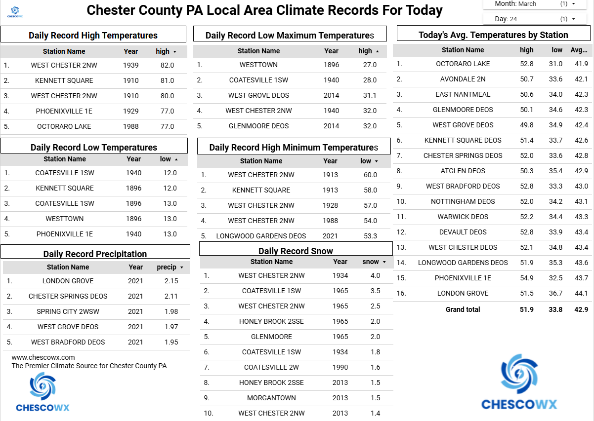
This morning was the 100th below freezing low of the season here in East Nantmeal. Here in EN we average 97 such days. This is the most below freezing days since 2018-19 when we had 104 days. With records here since 2004 the most were 120 days in 2013-14 and the least only 72 days in 2015-16. We will see below normal temperatures today before we moderate to near normal (low 50's) tomorrow. Thursday we should warm well into the 60's before rain arrives by Friday morning. Much colder this weekend with nighttime lows again below freezing.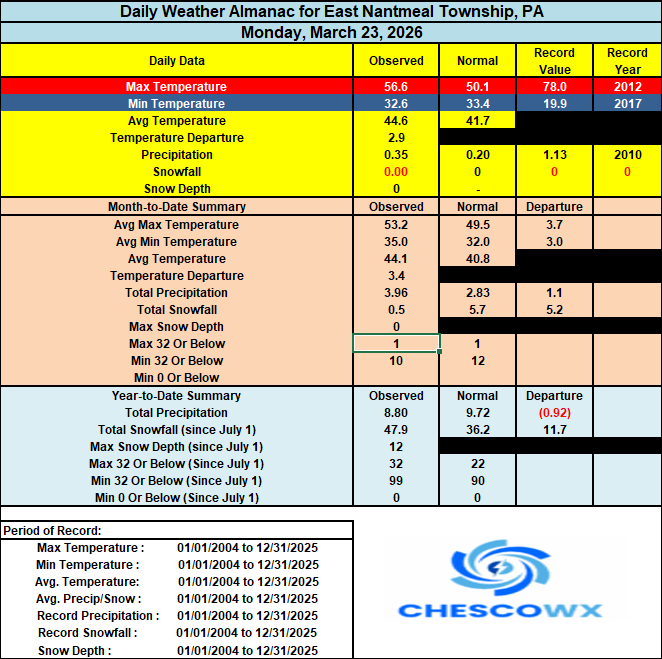

-
E PA/NJ/DE Spring 2026 Obs/Discussion
ChescoWx replied to PhiEaglesfan712's topic in Philadelphia Region
This morning was the 100th below freezing low of the season here in East Nantmeal. Here in EN we average 97 such days. This is the most below freezing days since 2018-19 when we had 104 days. With records here since 2004 the most were 120 days in 2013-14 and the least only 72 days in 2015-16. We will see below normal temperatures today before we moderate to near normal (low 50's) tomorrow. Thursday we should warm well into the 60's before rain arrives by Friday morning. Much colder this weekend with nighttime lows again below freezing.
- Today
-
Another 1" late yesterday afternoon into the overnight so we finished at 6" total.
-
That actually began on 3/31. At the time I had a side gig. That night I had to do an audit at a liquor store in methuen. Despite having company provided ID and a authorization letter from the alcohol company requesting their products be audited the owner of the liquor store was 100% convinced I was a government agent lol...I recall him saying something such as " only the government would send someone out in a blizzard"..lol....to make a long story short he kicked me out of his store lol..
-

2026-2027 El Nino
Terpeast replied to Stormchaserchuck1's topic in Weather Forecasting and Discussion
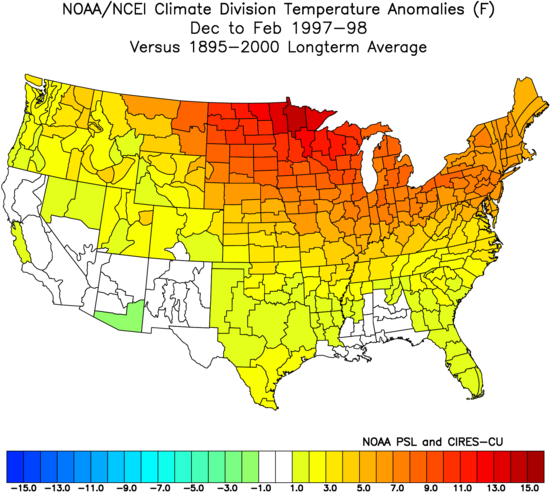
Thanks for sharing. I didn’t realize how well 23-24 matches up with 97-98. I thought it was a good 72-73 match, adjusted to today’s climate. Will be interesting to see how RONI plays out this year now that it is official. -
5.78 “ rain this month to date. Water pouring out of hillsides still this morning. Hopefully that’s it until Mayorch
-
Just further east down rt. 2 from @HoarfrostHubb but I'm giving the same grade and could be convinced of an A- given I wasn't here for the first three weeks of March to witness the melt. By the same token, I missed 3 out of 4 weeks of December when when we had good cold temperatures (and maybe a bit of snow??) as well. My criteria for a good winter is 'can I step out the door of my house and winter recreate.' The cold onset of winter allowed the weston ski track to make snow and provide good, consistent snow, I was able to ski out my door and at the great brook nordic center daily for 6+ weeks before I left the area at the end of February. And I got out on the local ice a few times as well before the big snows came. Up north the alpine skiing was good, the nordic skiing was good and I even got to skate on Lake Morey in VT which I've been wanting to do for some time now. I had hoped to do some ski touring up north on nice March days which isn't going to happen but I was able to explore Mt. Wachusett State park on my skis several times which was actually a lot more fun than I expected.
-
Iced up this morning; windshield was covered.
-
Oh. I don’t recall those. I figured you meant the April Fools storm
-
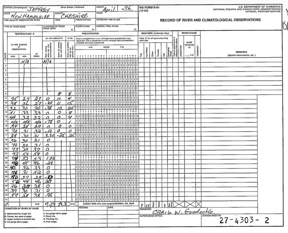
Is that the April record for Jaffrey?
-
Yup. 29.3” for the month
-

2026-2027 El Nino
bluewave replied to Stormchaserchuck1's topic in Weather Forecasting and Discussion
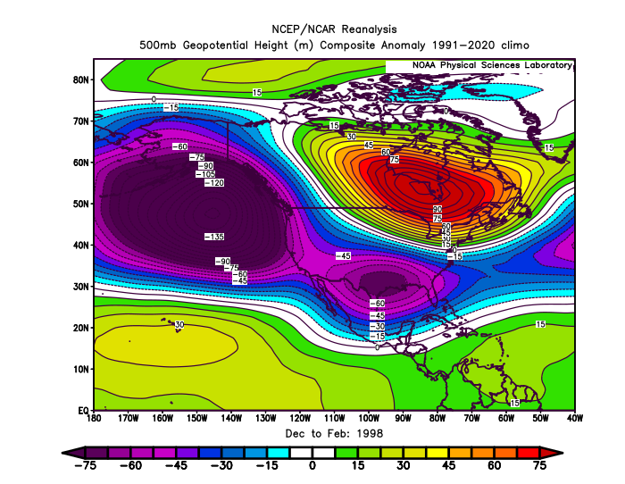
I don’t think RONI is a relevant metric for measuring El Niños since 2023-2024 had an even warmer North American atmospheric response than 1997-1998 did with a very similar 500 mb pattern.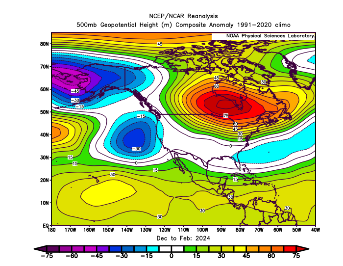

-
95-96 is at the top of my list ....
-
I feel like Jaffrey was pounded in both of those. Off to the original COOP forms…
-

2026-2027 El Nino
PhiEaglesfan712 replied to Stormchaserchuck1's topic in Weather Forecasting and Discussion
That one was weird, and really didn't behave as an el nino, due to a major volcano. Pinatubo actually caused a temporary decrease in global temperatures. If not for that, 1992 would have probably would have been another global warmest year on record (at the time), after a 3rd strong el nino in 10 years. Pinatubo caused the summer of 1992 to be one of the coldest on record CONUS, and longer term, the cold and snowy winters of 92-93, 93-94, and 95-96 in many places in the Eastern US. As for modoki el ninos, 2009-10 is probably the only strong el nino that's a modoki. -
The Eastah Nor’eastah of 96