All Activity
- Past hour
-

"Don’t do it" 2026 Blizzard obs, updates and pictures.
vortex95 replied to Ginx snewx's topic in New England
The below is a bit of a rant, but I know the snow weenies of this forum will appreciate detailed and proper meteorology when it comes to snowstorms! And I cannot emphasize this enough, when you know wx history so you can quote examples to support your position/argument, it makes a huge difference (see "one size does not fit all" statement below). "Goldilocks situation" -- first I have heard of this label concerning a snowstorm, at least for track. The Blizzard of '78 tracked farther NW, and look what the did, snowfall heavier both in absolute totals and areal coverage. https://www.ncei.noaa.gov/monitoring-content/snow-and-ice/rsi/nesis/19780205-19780207-5.78.jpg There are other cases, of course. There is no studies or literature I am aware of that say, "if a low pressure takes X track, that means the max amount of snow will be Y" or "X temps present, then Y snow." Actually, when you think about it meteorologically, these statements are ridiculous IMHO. Low pressure track is one of *many* factors for total snowfall, and can't be treated in a vacuum. The list is long, and I know the weenies here know the below, but worthy laying out anyways! 1) High pressure - Its position, NW, N, or NE? How strong/expansive? Is there even a high? (there are a few KU cases where *no* high existed). 2) UA jet structure/features - Is it just the PJ involved (northern stream), or the STJ (southern stream), or both? Is it a full phase of both jets (or s/w trofs)? Position of entrance/exit regions of the jets? When does this phase occur relative to the location of interest? 3) Antecedent air mass - How cold is it pre-storm? Low-level cold only or deep layer cold? Is there any cold at all pre-storm? (we know that can be huge - look at the Blizzard of '97!). 4) Size - How large is the storm, both sfc and aloft? Is it just a little "dent" at 500 (Feb 1983), or a massive 5 contour 500 cut-off (May 1977)? 5) RI - At what lat/lon does the RI take place, if any RI at all? RI is not required, neither is an intense sfc low - see the big snowstorm last month. 6) Speed/direction - Does the storm stall/slow/loop or move along? And slow movement for a blockbuster is not required. Look at the Bliz of '93. As typical w/ Gulf waves, it *flew* NE! And then you get the weird outliers, like March 8-9, 2013 (a CoastalWx fav). Low pressure 600 mi SE of ACK and yet 1-2 ft in parts of SNE. MQE gets 29.8" for a top 5 snowstorm (up to the time). So how does the work for a track correlation? The point is there is no "one size fits all" for snowstorms, and wx in general. Oh, we try to force things into such categories/classes, but nature doesn't give a hoot about what we try to do or think! And the article linked, in general, it has some glaring generalizations and glosses over important details, as to dilute things down for general public consumption? But it not just about things being diluted, some things are factually wrong or overstated/exaggerated. "The nor'easter quickly intensified to easily qualify as a “bomb cyclone" and featured thundersnow and lightning, two things rarely seen in snowstorms." First, "thundersnow and lightning" treated as two things? Well, you can't have one w/ the other. Saying "lightning" in this case is superfluous. If you have thunder, you *have* to have lightning, so just say "thundersnow." Second, thundersnow is not rare in snowstorms, or not as rare as claimed to be. Sure, at any *one* location it is rare, but when you include the entire areal coverage of the snow and the existence of the storm itself? "An unusual combination of winter and summer weather — thundersnow and lightning — flashed at times with this storm, thrilling meteorologists on air. That's because “you only see it in the most intense winter storms,” Where does it say the thundersnow only seen in the most intense winter storms? The famous Dec 1996 Cantore ORH video, that nor'easter was pretty avg for a winter storm for intensity. And based on what? Central pressure?, max winds?, total snowfall? You don't need an intense storm to get CSI and thus slantwise convection for thundersnow. The article mentions it if were any colder there would not been as much moisture in the air to feed that snowfall. Really? Anyone ever hear of the fluff factor and snow ratios? How about what happened in Jan-Feb 2015 in SNE, for that snowblitz, it was unusually *cold* for so much snow, and all-time records were set. So absolute total moisture availability is not always a deciding factor, neither are temps! "A little farther inland and its would have lost its ocean energy" Huh? Are we talking about tropical cyclones or baroclinic winter storms? And since when "ocean energy" required for intense blizzards and snowfalls? See the OH Valley Jan 1978 blizzard (957 mb) or November 1950 Appalachia monster. I could go on and on, but you get the idea! -
We got our revenge. It finally came.
- Today
-
We were so due for a season of cold in SE Canada.
-
Eps is nice
-
March 1990 had a great ice storm around here.
-
"Don’t do it" 2026 Blizzard obs, updates and pictures.
vortex95 replied to Ginx snewx's topic in New England
Really tired of these kind of statements from various media outlets and organizations (not upset at you MJO812 ), as if it is AK vs. the rest of U.S. for cold/snow, and anything in the CONUS for cold/snow that "outdoes" AK means it is significant. These kind of statements are more for content and engagement bait that drives the social media algorithm than anything else. Anchorages avg winter snowfall is 76.4" and so far this season, they have 65.6" as shown above. However, what they conveniently leave out on the infographic is that avg season-to-date snowfall for Anchorage is 61.4". So nothing unusual going on in Anchorage for snowfall this snow season. And Anchorage for a location in AK for snow is relatively "low" for the state as a whole, so not a good comparison location. Bu the general public doesn't know that. They think AK is all cold/snow to the extreme. See what's going on here? Make more out of what it really is, or turning the ordinary into the extraordinary for wx (all too often done these days by the MSM). It's the same for temps, and this created hype has already happened this winter. Well, we all know that when it CONUS is very cold, AK is often very mild, so temps warmer in AK in the winter than say in the Deep South are not uncommon. Why don't they compare Fairbanks for snowfall? That's b/c they have had 89" so far this winter. Well, that won't work for hype will it? Must be nice to cherry-pick locations to "force" significance. And there have been a significant number of winter seasons where locations in southern New England have outdone the larger cities in AK, so again, how is this a big deal in the large pix? -

Outta gas and Outta Time: Early March Winter Storm finale
mitchnick replied to Ji's topic in Mid Atlantic
.thumb.png.2b06d0ee7c29e84340cf40d1d1029dc3.png)
-

Outta gas and Outta Time: Early March Winter Storm finale
stormtracker replied to Ji's topic in Mid Atlantic
Euro better than 18z. BUT thats not saying much. Still not like the CMC or GFS -

"Don’t do it" 2026 Blizzard obs, updates and pictures.
tunafish replied to Ginx snewx's topic in New England
I wasn't even talking about his theory, I just think he is a gigantic turd. But now that we're talking about it... am I supposed to believe that all those observers conspired together to inflate their totals, via selective drift measurements, and that almost all of them reporting damn close to double what dipstick is saying? And the other guy in here thinks it's people were trying make the storm live up to the hype after the 'rug pull', just so they dont feel like they missed out on a generational storm? Wut? Do I think those measurements are 100% accurate, definitely not, but I'm talking within 15-25% of reality. You could convince me of the higher end, but not broadly. But dozens of people reporting 100% more than "what really fell" is ridiculous to me. Also highly doubt the NWS tried earnestly to convince him he had a higher total. Impressive display of narcissistic personality disorder, really. I think this is a guy who has a history of overreaction when it comes to jackpots and him missing out. He was having epic meltdowns leading up to this event. I dont think he can handle missing the earlier event this season and the jack on this. If I can't have it nobody can'd. -

Central PA Winter 25/26 Discussion and Obs
Itstrainingtime replied to MAG5035's topic in Upstate New York/Pennsylvania
GFS now essentially has moved completely south of the M/D line. -

Outta gas and Outta Time: Early March Winter Storm finale
CAPE replied to Ji's topic in Mid Atlantic
Yeah I'm out. Gotta be up in 5 hours. -

E PA/NJ/DE Winter 2025-26 Obs/Discussion
MJO812 replied to LVblizzard's topic in Philadelphia Region
0z AI north for next week 18z vs 0z

-
I there even one? Just another useless troll.
-
0z AI north for next week 18z vs 0z

-
should be a min number of posts before you can dole those out.
-
The 30-0 run against Illinois was probably the best UConn men’s basketball I’ve ever seen.
-

Outta gas and Outta Time: Early March Winter Storm finale
NorthArlington101 replied to Ji's topic in Mid Atlantic
EURO AI good. Dunno if I’ll make it to the normal one. Stormtracker is on his own
-
Outta gas and Outta Time: Early March Winter Storm finale
CAPE replied to Ji's topic in Mid Atlantic
Euro has it- 12z looked pretty damn good. 18z weaker and a bit too far south. -

Outta gas and Outta Time: Early March Winter Storm finale
jayyy replied to Ji's topic in Mid Atlantic
CMC / GFS seeing something the euro isn’t? Ooooor How far out is this thing? -
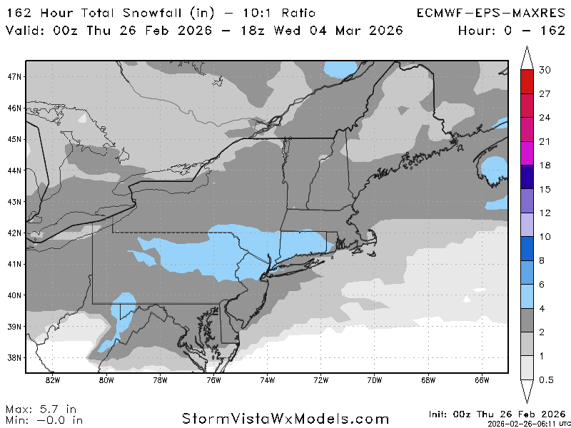
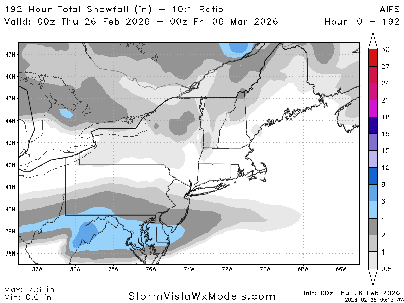
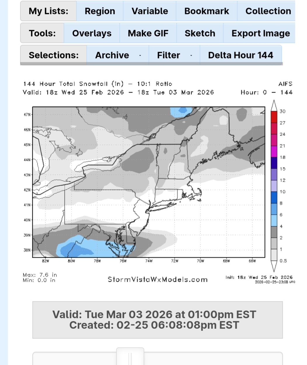
Models are pretty dry moving forward for the Northeast.
-
Outta gas and Outta Time: Early March Winter Storm finale
CAPE replied to Ji's topic in Mid Atlantic
0z GEFS a bit drier but fine. -
Outta gas and Outta Time: Early March Winter Storm finale
stormtracker replied to Ji's topic in Mid Atlantic
I'd give them their gold back for this -
Outta gas and Outta Time: Early March Winter Storm finale
stormtracker replied to Ji's topic in Mid Atlantic
Yeah, that's why you gotta stay close when I do pbp. Looking at SV maps is like looking at a child's coloring book -
Outta gas and Outta Time: Early March Winter Storm finale
CAPE replied to Ji's topic in Mid Atlantic
Its a thread the needle deal for sure, but as advertised the timing of that digging NS vorticity is such that there is surface HP in a favorable position, and just enough energy sliding underneath for potentially a moderate storm. Not buying the idea of 10", but 3-6 seems achievable. -

Pittsburgh/Western PA WINTER ‘25/‘26
Rd9108 replied to Burghblizz's topic in Upstate New York/Pennsylvania
CMC similar. Models are pretty locked in this far out.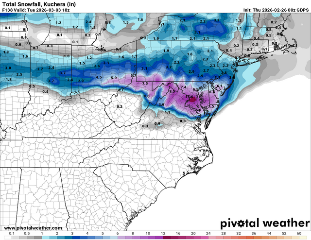


.png.0dbcdb4f535b182d6ae8dbf309b4f8ea.png)


.thumb.png.4150b06c63a21f61052e47a612bf1818.png)
