All Activity
- Past hour
-
.thumb.png.4150b06c63a21f61052e47a612bf1818.png)
July 2025 Obs/Disco ... possible historic month for heat
HIPPYVALLEY replied to Typhoon Tip's topic in New England
My eyes were burning, walking the dog this morning. -
July 2025 Obs/Disco ... possible historic month for heat
HIPPYVALLEY replied to Typhoon Tip's topic in New England
I just got two cords delivered yesterday. -
.17" of rain yesterday from the evening storm.
-

July 2025 Obs/Disco ... possible historic month for heat
rimetree replied to Typhoon Tip's topic in New England
Breathe it in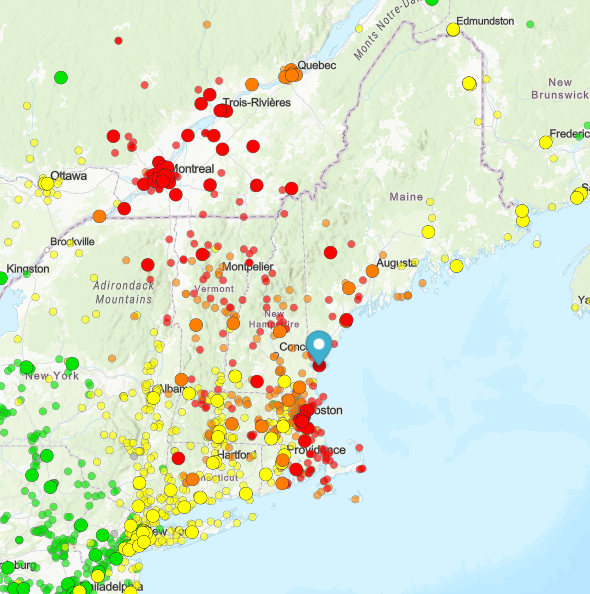
-
 August DCA _ NYC _ BOS ___ ORD _ ATL _ IAH ___ DEN _ PHX _ SEA 1.0 1.0 0.5 1.0 1.5 2.0 0.5 1.5 0.5
 -
July 2025 Obs/Disco ... possible historic month for heat
rimetree replied to Typhoon Tip's topic in New England
81/58...pretty much ideal. Hoping we can translate this to first week in Aug when down on the Cape. A little humidity won't hurt but don't want everything covered in dew. Doesn't look wet at this range so fingers crossed. -
My entire childhood it seemed every storm went north of me and hit Glen Burnie. They still do. That place is a magnet for storms. I'd be interested to see a map of thunderstorm frequency over the past 100 years. It would be interesting to see if some areas do better then others. Besides the obvious areas like Stephen City lol
-

July 2025 Obs/Disco ... possible historic month for heat
DavisStraight replied to Typhoon Tip's topic in New England
I could smell it walking the dog this morning. -
What heat wave? It was “hot” for 2 days this week. Lol this guy. He’s ruining your forum boys with his hysterics
-
I didn’t post anything about climate change. Posting observed temperatures and highlighting records from the recent heat wave is relevant weather related discussion. This is a weather board, no?
-
Just saw this topic and it saddens me greatly. I looked on him as a close neighbor friend from the triad area though we never met. He was level headed in his comments and put downs when needed. Prayers for your family and as well said by many others he will be GREATLY missed!
-

July 2025 Obs/Disco ... possible historic month for heat
HoarfrostHubb replied to Typhoon Tip's topic in New England
Just walking in our neighborhood it was visible right at ground level. -

July 2025 Obs/Disco ... possible historic month for heat
Damage In Tolland replied to Typhoon Tip's topic in New England
Driving around you can see it sitting right at ground level -
Climate Change https://r.tapatalk.com/shareLink?share_fid=13197&share_sfid=18&url=https%3A%2F%2Fwww%2Eamericanwx%2Ecom%2Fbb%2F&share_type=sf&link_source=app Looks like the appropriate forum for your interests. Those interested in that topic can follow you over there, no?
-

July 2025 Obs/Disco ... possible historic month for heat
powderfreak replied to Typhoon Tip's topic in New England
I take that back. Got out of the woods and can definitely see the haze. -

July 2025 Obs/Disco ... possible historic month for heat
Go Kart Mozart replied to Typhoon Tip's topic in New England
We need a 50% tariff on Canadian smoke. -

July 2025 Obs/Disco ... possible historic month for heat
Torch Tiger replied to Typhoon Tip's topic in New England
I see it. there it is. the cold shot -
July 2025 Obs/Disco ... possible historic month for heat
Torch Tiger replied to Typhoon Tip's topic in New England
Today Widespread haze. Areas of smoke. Sunny, with a high near 85. Northeast wind 5 to 7 mph becoming light and variable. Tonight Mostly cloudy, with a low around 60. South wind 3 to 6 mph. Sunday A chance of showers and thunderstorms before 1pm, then showers likely and possibly a thunderstorm between 1pm and 3pm, then a chance of showers and thunderstorms after 3pm. Cloudy, with a high near 76. Southwest wind 6 to 8 mph. Chance of precipitation is 60%. New rainfall amounts between a tenth and quarter of an inch, except higher amounts possible in thunderstorms. Sunday Night A chance of showers and thunderstorms, mainly before 7pm. Mostly cloudy, with a low around 66. South wind around 6 mph becoming calm in the evening. Chance of precipitation is 30%. New precipitation amounts of less than a tenth of an inch, except higher amounts possible in thunderstorms. Monday Sunny and hot, with a high near 92. Calm wind becoming north around 5 mph in the afternoon. Monday Night Mostly clear, with a low around 70. Light southwest wind. Tuesday Sunny and hot, with a high near 97. West wind 3 to 6 mph. Tuesday Night Mostly clear, with a low around 70. West wind 3 to 5 mph. Wednesday Mostly sunny and hot, with a high near 90. Light and variable wind becoming west around 6 mph in the morning. Wednesday Night A chance of showers after 2am. Partly cloudy, with a low around 66. Light and variable wind. Chance of precipitation is 30%. Thursday A chance of showers. Partly sunny, with a high near 82. Northwest wind 3 to 6 mph. Chance of precipitation is 30%. Thursday Night A chance of showers. Mostly cloudy, with a low around 60. Northwest wind 3 to 5 mph. Chance of precipitation is 30%. Friday Mostly sunny, with a high near 79. North wind around 6 mph. -

July 2025 Discussion-OBS - seasonable summer variability
SACRUS replied to wdrag's topic in New York City Metro
82 / 66 DT dropped a bit from the morning -

July 2025 Obs/Disco ... possible historic month for heat
kdxken replied to Typhoon Tip's topic in New England
People testing their wood stoves before the incoming cold shot. -

July 2025 Discussion-OBS - seasonable summer variability
FPizz replied to wdrag's topic in New York City Metro
96 yesterday -
July 2025 Obs/Disco ... possible historic month for heat
HoarfrostHubb replied to Typhoon Tip's topic in New England
Yup. We can smell it here. Very hazy. Blue tint -
The drought monitor shows normal but that's because it has rained plenty in areas all around me. I can't tell you how many times I see a t-storm out my south-facing window as they roll thru Rockville/Gaithersburg, etc. Some of those places have been hit 5-6 times since the last time I saw a drop. I've let the lawn go and am just trying to keep my flower garden alive. Leaves are even falling already. And no, it will not rain here this evening or anytime soon
-
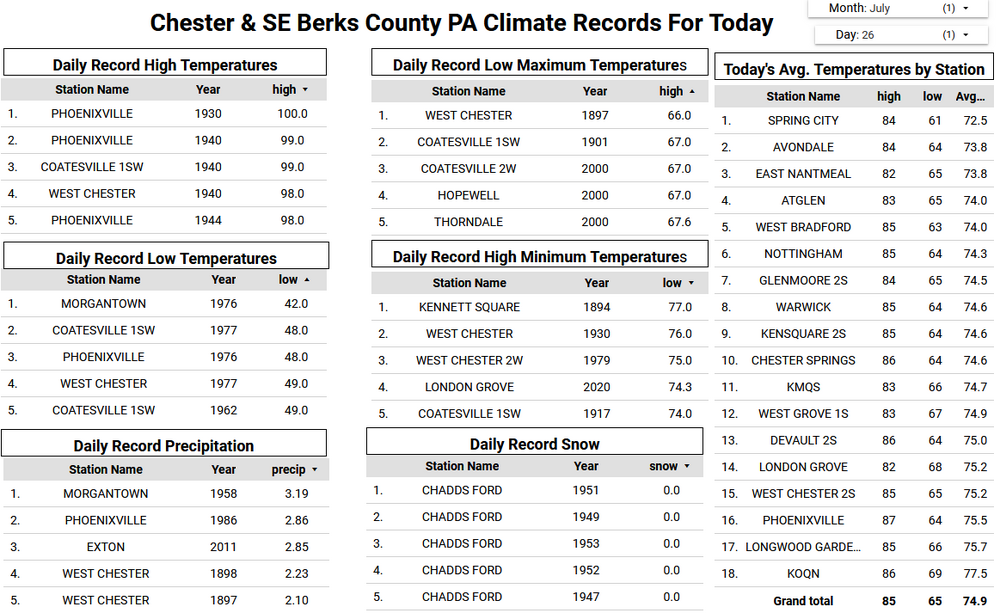
Today will be several days cooler with high temperatures mostly in the mid to upper 80's. So far this year Chester County has experienced only one heat wave (at least 3 consecutive 90+ days) back on June 23rd through June 26th. We have what may be our last chance of a 2025 summer heatwave early this week as Monday through Wednesday may see temperatures at or near 90 degrees. We then turn much cooler with a pattern change to well below normal temperatures as we close out July and move into August. The best chances of rain look to be tonight and later Sunday.

-

E PA/NJ/DE Summer 2025 Obs/Discussion
ChescoWx replied to Hurricane Agnes's topic in Philadelphia Region
Today will be several days cooler with high temperatures mostly in the mid to upper 80's. So far this year Chester County has experienced only one heat wave (at least 3 consecutive 90+ days) back on June 23rd through June 26th. We have what may be our last chance of a 2025 summer heatwave early this week as Monday through Wednesday may see temperatures at or near 90 degrees. We then turn much cooler with a pattern change to well below normal temperatures as we close out July and move into August. The best chances of rain look to be tonight and later Sunday.


